
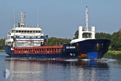
RIX UNION
General Cargo
Current Trip
Current Position
| Longitude | 3.78615° |
|---|---|
| Latitude | 51.15588° |
| Status | Under way using engine |
| Speed | 5 Knots |
| Course | 198° |
| Area | North Sea |
| Station | T-AIS |
| Position Received | Now |
Info
Information
The current position of RIX UNION is in North Sea with coordinates 51.15588° / 3.78615° as reported on 2024-04-25 13:35 by AIS to our vessel tracker app. The vessel's current speed is 5 Knots and is currently inside the port of GENT.
The vessel RIX UNION (IMO: 9256559, MMSI: 209992000) is a General Cargo that was built in 2001 ( 23 years old ). It's sailing under the flag of [CY] Cyprus.
In this page you can find informations about the vessels current position, last detected port calls, and current voyage information. If the vessels is not in coverage by AIS you will find the latest position.
The current position of RIX UNION is detected by our AIS receivers and we are not responsible for the reliability of the data. The last position was recorded while the vessel was in Coverage by the Ais receivers of our vessel tracking app.
The current draught of RIX UNION as reported by AIS is 3.9 meters
Weather
| Temperature | 10.8°C / 51.44°F |
|---|---|
| Wind Speed | 15 knots |
| Direction | 230° SW |
| Pressure | 1003.6 hPa |
| Humidity | 59.2 % |
| Cloud Coverage | 100 % |
Featured Company
Last Port Calls
| Port | Arrival | Departure | Time In Port |
|---|---|---|---|
| 2024-04-25 13:28 | |||
| 2024-04-21 11:34 | 2024-04-21 12:12 | 37 m | |
| 2024-04-09 14:23 | 2024-04-16 13:54 | 6 d | |
| 2024-03-31 21:37 | 2024-04-02 11:02 | 1 d | |
| 2024-03-26 18:41 | 2024-03-28 05:33 | 1 d | |
| 2024-03-26 04:05 | 2024-03-26 17:03 | 12 h | |
| 2024-03-11 12:19 | 2024-03-13 22:31 | 2 d | |
| 2024-03-06 01:59 | 2024-03-07 01:32 | 23 h | |
| 2024-03-02 11:33 | 2024-03-02 13:35 | 2 h | |
| 2024-02-26 19:34 | 2024-02-29 16:23 | 2 d |
Last Trips
| Origin | Departure | Destination | Arrival | Distance | |
|---|---|---|---|---|---|
| 2024-04-21 14:12 | 2024-04-25 15:28 | 175.91 nm | |||
| 2024-04-16 14:54 | 2024-04-21 13:34 | 1031.90 nm | |||
| 2024-04-02 13:02 | 2024-04-09 15:23 | 551.90 nm | |||
| 2024-03-28 06:33 | 2024-03-31 23:37 | 809.34 nm | |||
| 2024-03-26 18:03 | 2024-03-26 19:41 | 19.16 nm | |||
| 2024-03-13 22:31 | 2024-03-26 05:05 | 990.57 nm | |||
| 2024-03-07 01:32 | 2024-03-11 12:19 | 818.60 nm | |||
| 2024-03-02 14:35 | 2024-03-06 01:59 | 813.14 nm | |||
| 2024-02-29 17:23 | 2024-03-02 12:33 | 407.68 nm | |||
| 2024-02-26 00:59 | 2024-02-26 20:34 | 126.02 nm |
Events
| Time | Event | Details | Position / Dest | Info |
|---|---|---|---|---|
| 2024-04-25 13:28 | PORT ARRIVAL |
|
51.16638 / 3.79261
[BE] GENT
|
Speed: 8.1 kn Course: 200.8° |
| 2024-04-25 12:10 | START Moving | 0.46 nm, North West of TERNEUZEN |
51.32635 / 3.81887
BEGNE
|
Speed: 4.5 kn Course: 151° |
| 2024-04-25 11:27 | STOP Moving | 0.57 nm, North West of TERNEUZEN |
51.32798 / 3.81762
BEGNE
|
Speed: 0.3 kn Course: 154° |
| 2024-04-25 11:16 | START Moving | 0.83 nm, North West of TERNEUZEN |
51.33173 / 3.81438
BEGNE
|
Speed: 3.1 kn Course: 154° |
| 2024-04-25 10:39 | STOP Moving | 1.21 nm, North West of TERNEUZEN |
51.33757 / 3.81036
BEGNE
|
Speed: 0.3 kn Course: 173° |
| 2024-04-25 03:58 | START Moving | 15.4 nm, North West of NEELTJE JANS |
51.79939 / 3.39513
BEGNE
|
Speed: 3.6 kn Course: 209° |
| 2024-04-25 03:54 | Status Changed | Under way using engine At anchor |
51.80118 / 3.39749
BEGNE
|
Speed: 0.6 kn Course: 252° |
| 2024-04-25 03:06 | Status Changed | At anchor Default |
51.80104 / 3.39917
BEGNE
|
Speed: 0.6 kn Course: 248° |
| 2024-04-25 03:00 | Status Changed | Default At anchor |
51.80108 / 3.39916
BEGNE
|
Speed: 0.6 kn Course: 248° |
| 2024-04-25 02:51 | Status Changed | At anchor Default |
51.80104 / 3.39929
BEGNE
|
Speed: 0.1 kn Course: 249° |