
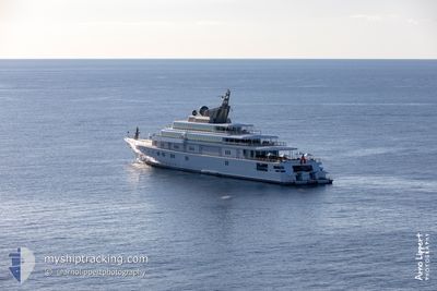
RISING SUN
Yacht
Current Trip
| Time Travelled | 1 day |
|---|---|
| Remaining Time | --- |
| Distance Travelled | 51.93 nm |
| Remaining Distance | --- |
| AVG Speed | 18.1 Knots |
| MAX Speed | 19.2 Knots |
| AVG Wind | 15.6 knots |
| MAX Wind | 17.4 knots |
| MIN Temp | 25.8°C / 78.44°F |
| MAX Temp | 26.7°C / 80.06°F |
| Draught | 5 m |
| Position Received | 1 d ago |
Current Position
| Longitude | -64.09573° |
|---|---|
| Latitude | 18.50533° |
| Status | Under way using engine |
| Speed | 18.2 Knots |
| Course | 61.1° |
| Area | Caribbean Sea |
| Station | T-AIS |
| Position Received | 1 d ago |
Info
Information
The current position of RISING SUN is in Caribbean Sea with coordinates 18.50533° / -64.09573° as reported on 2024-04-15 00:36 by AIS to our vessel tracker app. The vessel's current speed is 18.2 Knots and is heading at the port of ST THOMAS. The estimated time of arrival as calculated by MyShipTracking vessel tracking app is 2024-04-22 11:00 LT
The vessel RISING SUN (IMO: 8982307, MMSI: 319011000) is a Yacht that was built in 2004 ( 20 years old ). It's sailing under the flag of [KY] Cayman Is.
In this page you can find informations about the vessels current position, last detected port calls, and current voyage information. If the vessels is not in coverage by AIS you will find the latest position.
The current position of RISING SUN is detected by our AIS receivers and we are not responsible for the reliability of the data. The last position was recorded while the vessel was in Coverage by the Ais receivers of our vessel tracking app.
The current draught of RISING SUN as reported by AIS is 5 meters
Weather
| Temperature | 25.9°C / 78.62°F |
|---|---|
| Wind Speed | 17 knots |
| Direction | 85° E |
| Pressure | 1014.7 hPa |
| Humidity | 83.8 % |
| Cloud Coverage | --- |
Featured Company
Last Port Calls
| Port | Arrival | Departure | Time In Port |
|---|---|---|---|
| 2024-04-11 22:52 | 2024-04-14 21:43 | 2 d | |
| 2024-03-29 22:14 | 2024-04-05 15:31 | 6 d | |
| 2024-02-10 12:51 | 2024-02-16 01:44 | 5 d |
Most Visited Ports (Last year)
| Port | Arrivals | |
|---|---|---|
| 4 | ||
| 2 | ||
| 2 | ||
| 1 | ||
| 1 | ||
| 1 |
Last Trips
| Origin | Departure | Destination | Arrival | Distance | |
|---|---|---|---|---|---|
| 2024-04-05 11:31 | 2024-04-11 18:52 | 48.66 nm | |||
| 2024-02-15 21:44 | 2024-03-29 18:14 | 328.18 nm | |||
| 2024-01-20 18:19 | 2024-02-10 08:51 | 133.45 nm |
Events
| Time | Event | Details | Position / Dest | Info |
|---|---|---|---|---|
| 2024-04-15 00:36 | OUT of Coverage |
18.50533 / -64.09573
Caribbean Sea
GI GIB>VI STT
|
Speed: 18.2 kn Course: 61.1° |
|
| 2024-04-15 00:23 | Destination Changed | GI GIB>VI STT VI STT>VI STT |
18.47428 / -64.15705
GI GIB>VI STT
|
Speed: 19 kn Course: 62.9° |
| 2024-04-15 00:23 | ETA Changed | 2024/04/22 11:00 2024/04/05 23:30 |
18.47428 / -64.15705
GI GIB>VI STT
|
Speed: 19 kn Course: 62.9° |
| 2024-04-14 22:43 | Change Sea Area | British Virgin Islands part of the Caribbean Sea Puerto Rican part of the Caribbean Sea |
18.27607 / -64.65137
Caribbean Sea
|
Speed: 18.4 kn Course: 91.6° |
| 2024-04-14 21:43 | PORT DEPARTURE |
|
18.31985 / -64.92642
VI STT>VI STT
|
Speed: 6.2 kn Course: 160° |
| 2024-04-14 21:37 | START Moving |
18.33001 / -64.92833
[VI] ST THOMAS
|
Speed: 3.4 kn Course: 178° |
|
| 2024-04-14 21:18 | Status Changed | Under way using engine Moored |
18.33446 / -64.92086
[VI] ST THOMAS
|
Speed: 0.2 kn Course: 70° |
| 2024-04-12 00:50 | ETA Changed | 2024/04/05 23:30 2024/04/05 19:19 |
18.33473 / -64.92095
[VI] ST THOMAS
|
Speed: Course: 69° |
| 2024-04-11 23:20 | Status Changed | Moored Under way using engine |
18.33471 / -64.92094
[VI] ST THOMAS
|
Speed: Course: 70° |
| 2024-04-11 23:13 | STOP Moving |
18.33460 / -64.92105
[VI] ST THOMAS
|
Speed: 0.3 kn Course: 67° |