
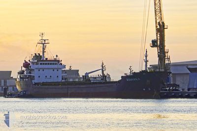
RIMONA
Bulk Carrier
Current Trip
| Time Travelled | 11 h, 31 mins |
|---|---|
| Remaining Time | 17 mins |
| Distance Travelled | 102.71 nm |
| Remaining Distance | 8.85 nm |
| AVG Speed | 9.9 Knots |
| MAX Speed | 10.3 Knots |
| AVG Wind | 15.7 knots |
| MAX Wind | 19.4 knots |
| MIN Temp | 19.5°C / 67.1°F |
| MAX Temp | 21.8°C / 71.24°F |
| Draught | 4.3 m |
| Position Received | 44 m ago |
Current Position
| Longitude | 31.75467° |
|---|---|
| Latitude | 31.63633° |
| Status | At anchor |
| Speed | 2.4 Knots |
| Course | 255° |
| Area | Mediterranean Sea - Eastern Basin |
| Station | T-AIS |
| Position Received | 44 m ago |
Info
Information
The current position of RIMONA is in Mediterranean Sea - Eastern Basin with coordinates 31.63633° / 31.75467° as reported on 2024-04-25 20:33 by AIS to our vessel tracker app. The vessel's current speed is 2.4 Knots and is heading at the port of DAMIETTA. The estimated time of arrival as calculated by MyShipTracking vessel tracking app is 2024-04-25 21:35 LT
The vessel RIMONA (IMO: 9468750, MMSI: 256821000) is a Bulk Carrier that was built in 2007 ( 17 years old ). It's sailing under the flag of [MT] Malta.
In this page you can find informations about the vessels current position, last detected port calls, and current voyage information. If the vessels is not in coverage by AIS you will find the latest position.
The current position of RIMONA is detected by our AIS receivers and we are not responsible for the reliability of the data. The last position was recorded while the vessel was in Coverage by the Ais receivers of our vessel tracking app.
The current draught of RIMONA as reported by AIS is 4.3 meters
Weather
| Temperature | 19.8°C / 67.64°F |
|---|---|
| Wind Speed | 20 knots |
| Direction | 317° NW |
| Pressure | 1009.3 hPa |
| Humidity | 78.4 % |
| Cloud Coverage | 100 % |
Featured Company
Last Port Calls
| Port | Arrival | Departure | Time In Port |
|---|---|---|---|
| 2024-04-22 15:52 | 2024-04-25 09:47 | 2 d | |
| 2024-04-22 11:48 | 2024-04-22 15:39 | 3 h | |
| 2024-04-18 01:20 | 2024-04-21 08:05 | 3 d | |
| 2024-04-11 06:50 | 2024-04-12 12:36 | 1 d | |
| 2024-04-05 12:54 | 2024-04-10 11:35 | 4 d | |
| 2024-04-02 07:29 | 2024-04-04 12:59 | 2 d | |
| 2024-03-21 15:07 | 2024-03-21 15:46 | 39 m | |
| 2024-03-17 13:37 | 2024-03-20 13:42 | 3 d | |
| 2024-02-21 15:40 | 2024-02-26 10:23 | 4 d | |
| 2024-02-17 20:55 | 2024-02-20 05:43 | 2 d |
Most Visited Ports (Last year)
| Port | Arrivals | |
|---|---|---|
| 3 | ||
| 3 | ||
| 3 | ||
| 2 | ||
| 2 | ||
| 2 |
Last Trips
| Origin | Departure | Destination | Arrival | Distance | |
|---|---|---|---|---|---|
| 2024-04-22 17:39 | 2024-04-22 17:52 | 1.95 nm | |||
| 2024-04-21 10:05 | 2024-04-22 13:48 | 151.15 nm | |||
| 2024-04-12 14:36 | 2024-04-18 03:20 | 1216.29 nm | |||
| 2024-04-10 13:35 | 2024-04-11 08:50 | 59.70 nm | |||
| 2024-04-04 14:59 | 2024-04-05 14:54 | 225.63 nm | |||
| 2024-03-21 16:46 | 2024-04-02 09:29 | 1740.40 nm | |||
| 2024-03-20 13:42 | 2024-03-21 16:07 | 215.84 nm | |||
| 2024-02-26 13:23 | 2024-03-17 13:37 | 2268.22 nm | |||
| 2024-02-20 07:43 | 2024-02-21 18:40 | 222.71 nm | |||
| 2024-02-11 22:39 | 2024-02-17 22:55 | 992.47 nm |
Events
| Time | Event | Details | Position / Dest | Info |
|---|---|---|---|---|
| 2024-04-25 20:45 | STOP Moving | 9.97 nm, North of DAMIETTA |
31.63383 / 31.75567
EG DAM
|
Speed: Course: 311° |
| 2024-04-25 20:39 | Status Changed | Default At anchor |
31.63333 / 31.75333
EG DAM
|
Speed: 2.4 kn Course: 255° |
| 2024-04-25 20:32 | Status Changed | At anchor Under way using engine |
31.63667 / 31.75500
EG DAM
|
Speed: 2.1 kn Course: 238° |
| 2024-04-25 20:22 | Status Changed | Under way using engine Default |
31.64633 / 31.76133
EG DAM
|
Speed: 4.4 kn Course: 170° |
| 2024-04-25 20:18 | Status Changed | Default Under way using engine |
31.65417 / 31.76033
EG DAM
|
Speed: 8 kn Course: 160° |
| 2024-04-25 20:12 | Status Changed | Under way using engine Default |
31.66400 / 31.75717
EG DAM
|
Speed: 4.5 kn Course: 140° |
| 2024-04-25 20:06 | IN Coverage |
31.66217 / 31.75800
Mediterranean Sea - Eastern Basin
EG DAM
|
Speed: 8 kn Course: 160° |
|
| 2024-04-25 19:01 | Status Changed | Default Under way using engine |
31.74967 / 31.59867
EG DAM
|
Speed: 9.3 kn Course: 90° |
| 2024-04-25 18:59 | OUT of Coverage |
31.74967 / 31.59417
Mediterranean Sea - Eastern Basin
EG DAM
|
Speed: 9.3 kn Course: 90° |
|
| 2024-04-25 18:34 | Status Changed | Under way using engine Default |
31.74950 / 31.51700
EG DAM
|
Speed: 9.6 kn Course: 89° |