
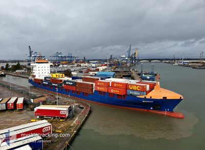
RANGER
Container Ship
Current Trip
| Time Travelled | 1 day |
|---|---|
| Remaining Time | 1 h, 17 mins |
| Distance Travelled | 614.15 nm |
| Remaining Distance | 34.50 nm |
| AVG Speed | 16.5 Knots |
| MAX Speed | 18.7 Knots |
| AVG Wind | 8.9 knots |
| MAX Wind | 15 knots |
| MIN Temp | 7.2°C / 44.96°F |
| MAX Temp | 10.6°C / 51.08°F |
| Draught | 7.1 m |
| Position Received | 32 m ago |
Current Position
| Longitude | 3.27984° |
|---|---|
| Latitude | 51.89721° |
| Status | Under way using engine |
| Speed | 18.4 Knots |
| Course | 70.7° |
| Area | North Sea |
| Station | T-AIS |
| Position Received | 32 m ago |
Info
Information
The current position of RANGER is in North Sea with coordinates 51.89721° / 3.27984° as reported on 2024-04-25 03:04 by AIS to our vessel tracker app. The vessel's current speed is 18.4 Knots and is heading at the port of ROTTERDAM. The estimated time of arrival as calculated by MyShipTracking vessel tracking app is 2024-04-25 04:53 LT
The vessel RANGER (IMO: 9322542, MMSI: 209696000) is a Container Ship that was built in 2005 ( 19 years old ). It's sailing under the flag of [CY] Cyprus.
In this page you can find informations about the vessels current position, last detected port calls, and current voyage information. If the vessels is not in coverage by AIS you will find the latest position.
The current position of RANGER is detected by our AIS receivers and we are not responsible for the reliability of the data. The last position was recorded while the vessel was in Coverage by the Ais receivers of our vessel tracking app.
The current draught of RANGER as reported by AIS is 7.1 meters
Weather
| Temperature | 7.3°C / 45.14°F |
|---|---|
| Wind Speed | 11 knots |
| Direction | 304° NW |
| Pressure | 1007.7 hPa |
| Humidity | 60.8 % |
| Cloud Coverage | 100 % |
Featured Company
Last Port Calls
| Port | Arrival | Departure | Time In Port |
|---|---|---|---|
| 2024-04-22 09:50 | 2024-04-23 14:22 | 1 d | |
| 2024-04-20 04:15 | 2024-04-20 17:09 | 12 h | |
| 2024-04-19 23:52 | 2024-04-20 03:10 | 3 h | |
| 2024-04-18 23:50 | 2024-04-19 22:03 | 22 h | |
| 2024-04-18 02:44 | 2024-04-18 22:20 | 19 h | |
| 2024-04-18 02:31 | |||
| 2024-04-14 17:29 | 2024-04-16 10:27 | 1 d | |
| 2024-04-12 21:28 | 2024-04-13 01:34 | 4 h | |
| 2024-04-12 08:11 | 2024-04-12 21:24 | 13 h | |
| 2024-04-11 12:45 | 2024-04-12 06:37 | 17 h |
Most Visited Ports (Last year)
| Port | Arrivals | |
|---|---|---|
| 35 | ||
| 24 | ||
| 18 | ||
| 14 | ||
| 11 | ||
| 8 |
Last Trips
| Origin | Departure | Destination | Arrival | Distance | |
|---|---|---|---|---|---|
| 2024-04-20 19:09 | 2024-04-22 10:50 | 627.24 nm | |||
| 2024-04-20 05:10 | 2024-04-20 06:15 | 15.61 nm | |||
| 2024-04-20 00:03 | 2024-04-20 01:52 | 16.39 nm | |||
| 2024-04-19 00:20 | 2024-04-19 01:50 | 15.90 nm | |||
| 2024-04-16 11:27 | 2024-04-18 04:44 | 652.81 nm | |||
| 2024-04-16 11:27 | 2024-04-18 04:31 | 652.47 nm | |||
| 2024-04-13 03:34 | 2024-04-14 18:29 | 629.82 nm | |||
| 2024-04-12 23:24 | 2024-04-12 23:28 | 0.64 nm | |||
| 2024-04-12 08:37 | 2024-04-12 10:11 | 16.08 nm | |||
| 2024-04-09 21:55 | 2024-04-11 14:45 | 651.59 nm |
Events
| Time | Event | Details | Position / Dest | Info |
|---|---|---|---|---|
| 2024-04-25 03:15 | Status Changed | Default Under way using engine |
51.91396 / 3.36259
NLRTM
|
Speed: 18.4 kn Course: 70.7° |
| 2024-04-25 01:50 | Change Sea Area | Dutch part of the North Sea Belgian part of the North Sea |
51.78745 / 2.70191
North Sea
NLRTM
|
Speed: 18.1 kn Course: 71.1° |
| 2024-04-25 01:08 | Draught Changed | 7.1 7 |
51.64894 / 2.46048
NLRTM
|
Speed: 18 kn Course: 38.2° |
| 2024-04-25 01:08 | ETA Changed | 2024/04/25 04:10 2024/04/25 04:00 |
51.64894 / 2.46048
NLRTM
|
Speed: 18 kn Course: 38.2° |
| 2024-04-25 00:56 | Change Sea Area | Belgian part of the North Sea French part of the North Sea |
51.60215 / 2.40005
North Sea
NLRTM
|
Speed: 17.7 kn Course: 38.9° |
| 2024-04-25 00:56 | Status Changed | Under way using engine Default |
51.60215 / 2.40005
NLRTM
|
Speed: 17.6 kn Course: 38° |
| 2024-04-25 00:39 | IN Coverage |
51.60215 / 2.40005
North Sea
NLRTM
|
Speed: 17.7 kn Course: 38.9° |
|
| 2024-04-24 22:53 | Status Changed | Default Under way using engine |
51.13392 / 1.83318
NLRTM
|
Speed: 17.4 kn Course: 50.2° |
| 2024-04-24 22:48 | OUT of Coverage |
51.11850 / 1.80528
North Sea
NLRTM
|
Speed: 17.4 kn Course: 50.2° |
|
| 2024-04-24 22:42 | Status Changed | Under way using engine Default |
51.10028 / 1.77047
NLRTM
|
Speed: 17.5 kn Course: 50° |