
PROFESSOR B
General Cargo
Current Trip
| Time Travelled | --- |
|---|---|
| Remaining Time | --- |
| Distance Travelled | --- |
| Remaining Distance | --- |
| AVG Speed | --- |
| MAX Speed | --- |
| AVG Wind | --- |
| MAX Wind | --- |
| MIN Temp | --- |
| MAX Temp | --- |
| Draught | 8.2 m |
| Position Received | 2 h, 35 m ago |
Current Position
| Longitude | 32.32739° |
|---|---|
| Latitude | 31.35883° |
| Status | Under way using engine |
| Speed | 2.1 Knots |
| Course | 12° |
| Area | Mediterranean Sea - Eastern Basin |
| Station | T-AIS |
| Position Received | 2 h, 35 m ago |
Info
Information
The current position of PROFESSOR B is in Mediterranean Sea - Eastern Basin with coordinates 31.35883° / 32.32739° as reported on 2024-04-25 15:21 by AIS to our vessel tracker app. The vessel's current speed is 2.1 Knots
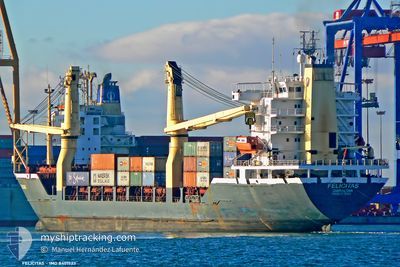
The vessel PROFESSOR B (IMO: 8401523, MMSI: 620040000) is a General Cargo that was built in 1984 ( 40 years old ). It's sailing under the flag of [KM] Comoros.
In this page you can find informations about the vessels current position, last detected port calls, and current voyage information. If the vessels is not in coverage by AIS you will find the latest position.
The current position of PROFESSOR B is detected by our AIS receivers and we are not responsible for the reliability of the data. The last position was recorded while the vessel was in Coverage by the Ais receivers of our vessel tracking app.
The current draught of PROFESSOR B as reported by AIS is 8.2 meters
Weather
| Temperature | 20.6°C / 69.08°F |
|---|---|
| Wind Speed | 22 knots |
| Direction | 319° NW |
| Pressure | 1006.6 hPa |
| Humidity | 84.4 % |
| Cloud Coverage | 98 % |
Featured Company
Last Port Calls
| Port | Arrival | Departure | Time In Port |
|---|---|---|---|
| 2024-03-28 23:06 | |||
| 2024-03-07 08:41 | 2024-03-11 10:20 | 4 d | |
| 2024-03-01 15:16 | |||
| 2024-02-08 17:56 | 2024-02-13 22:53 | 5 d | |
| 2024-02-05 19:05 | 2024-02-08 02:35 | 2 d | |
| 2024-02-03 13:01 | 2024-02-03 19:12 | 6 h |
Most Visited Ports (Last year)
| Port | Arrivals | |
|---|---|---|
| 5 | ||
| 4 | ||
| 3 | ||
| 3 | ||
| 2 | ||
| 1 |
Last Trips
| Origin | Departure | Destination | Arrival | Distance | |
|---|---|---|---|---|---|
| 2024-03-11 12:20 | 2024-03-29 02:06 | 699.86 nm | |||
| 2024-03-01 17:16 | 2024-03-07 10:41 | 943.32 nm | |||
| 2024-02-08 04:35 | 2024-02-08 19:56 | 130.93 nm | |||
| 2024-02-03 21:12 | 2024-02-05 21:05 | 7.86 nm | |||
| 2024-01-27 13:29 | 2024-02-03 15:01 | 1052.40 nm |
Events
| Time | Event | Details | Position / Dest | Info |
|---|---|---|---|---|
| 2024-04-25 15:48 | STOP Moving | 6.48 nm, North of PORT SAID |
31.35900 / 32.32410
PORT SAID
|
Speed: 0.1 kn Course: 328° |
| 2024-04-25 15:28 | Status Changed | Default Under way using engine |
31.36076 / 32.32388
PORT SAID
|
Speed: 2.1 kn Course: 12° |
| 2024-04-25 15:21 | OUT of Coverage |
31.35883 / 32.32739
Mediterranean Sea - Eastern Basin
PORT SAID
|
Speed: 2.1 kn Course: 72.4° |
|
| 2024-04-25 15:18 | Status Changed | Under way using engine Default |
31.35909 / 32.32562
PORT SAID
|
Speed: 2.8 kn Course: 58° |
| 2024-04-25 14:54 | Status Changed | Default Under way using engine |
31.38121 / 32.29462
PORT SAID
|
Speed: 8.9 kn Course: 149.6° |
| 2024-04-25 14:47 | Status Changed | Under way using engine Default |
31.39695 / 32.28395
PORT SAID
|
Speed: 8.8 kn Course: 150° |
| 2024-04-25 14:28 | Status Changed | Default Under way using engine |
31.43614 / 32.25858
PORT SAID
|
Speed: 8.4 kn Course: 161.3° |
| 2024-04-25 14:16 | Status Changed | Under way using engine Default |
31.46361 / 32.24545
PORT SAID
|
Speed: 8.5 kn Course: 153° |
| 2024-04-25 14:04 | IN Coverage |
31.46060 / 32.24684
Mediterranean Sea - Eastern Basin
PORT SAID
|
Speed: 8.5 kn Course: 157.3° |
|
| 2024-04-25 08:50 | OUT of Coverage |
32.13726 / 31.40556
Mediterranean Sea - Eastern Basin
PORT SAID
|
Speed: 11.9 kn Course: 128.7° |