
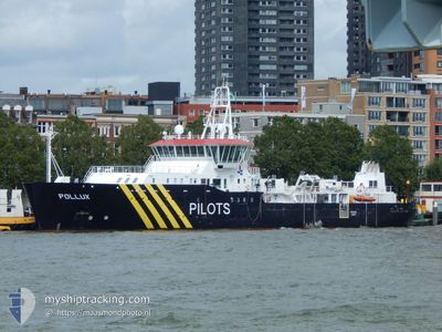
POLLUX (PILOTVESSEL)
Pilot Ship
Current Trip
VLISSINGEN
| Time Travelled | 1 day |
|---|---|
| Remaining Time | --- |
| Distance Travelled | 209.98 nm |
| Remaining Distance | --- |
| AVG Speed | 8.6 Knots |
| MAX Speed | 15.4 Knots |
| AVG Wind | 21.3 knots |
| MAX Wind | 30 knots |
| MIN Temp | 7.3°C / 45.14°F |
| MAX Temp | 10.3°C / 50.54°F |
| Draught | 5 m |
| Position Received | Now |
Current Position
| Longitude | 3.24367° |
|---|---|
| Latitude | 51.75283° |
| Status | Under way using engine |
| Speed | 1.7 Knots |
| Course | 8° |
| Area | North Sea |
| Station | T-AIS |
| Position Received | Now |
Info
Information
The current position of POLLUX (PILOTVESSEL) is in North Sea with coordinates 51.75283° / 3.24367° as reported on 2024-04-20 06:29 by AIS to our vessel tracker app. The vessel's current speed is 1.7 Knots
The vessel POLLUX (PILOTVESSEL) (IMO: 9496953, MMSI: 244790810) is a Pilot Ship that was built in 2013 ( 11 years old ). It's sailing under the flag of [NL] Netherlands.
In this page you can find informations about the vessels current position, last detected port calls, and current voyage information. If the vessels is not in coverage by AIS you will find the latest position.
The current position of POLLUX (PILOTVESSEL) is detected by our AIS receivers and we are not responsible for the reliability of the data. The last position was recorded while the vessel was in Coverage by the Ais receivers of our vessel tracking app.
The current draught of POLLUX (PILOTVESSEL) as reported by AIS is 5 meters
Weather
| Temperature | 8°C / 46.4°F |
|---|---|
| Wind Speed | 24 knots |
| Direction | 354° N |
| Pressure | 1022.2 hPa |
| Humidity | 62.2 % |
| Cloud Coverage | 100 % |
Featured Company
Last Port Calls
| Port | Arrival | Departure | Time In Port |
|---|---|---|---|
| 2024-04-08 19:51 | 2024-04-18 07:53 | 9 d | |
| 2024-03-28 12:57 | 2024-04-04 07:59 | 6 d | |
| 2024-03-14 12:49 | 2024-03-21 09:00 | 6 d | |
| 2024-02-29 11:42 | 2024-03-07 09:43 | 6 d | |
| 2024-02-15 13:03 | 2024-02-22 09:14 | 6 d | |
| 2024-02-01 12:11 | 2024-02-08 09:18 | 6 d |
Most Visited Ports (Last year)
| Port | Arrivals | |
|---|---|---|
| 86 | ||
| 20 | ||
| 2 | ||
| 1 |
Last Trips
| Origin | Departure | Destination | Arrival | Distance | |
|---|---|---|---|---|---|
| 2024-04-04 09:59 | 2024-04-08 21:51 | 366.72 nm | |||
| 2024-03-21 10:00 | 2024-03-28 13:57 | 654.61 nm | |||
| 2024-03-07 10:43 | 2024-03-14 13:49 | 568.88 nm | |||
| 2024-02-22 10:14 | 2024-02-29 12:42 | 625.58 nm | |||
| 2024-02-08 10:18 | 2024-02-15 14:03 | 633.39 nm | |||
| 2024-01-25 10:13 | 2024-02-01 13:11 | 556.64 nm |
Events
| Time | Event | Details | Position / Dest | Info |
|---|---|---|---|---|
| 2024-04-20 05:15 | STOP Moving | 18.43 nm, North West of OOSTWATERING |
51.72100 / 3.23183
VLISSINGEN
|
Speed: 0.3 kn Course: 31° |
| 2024-04-20 02:12 | START Moving | 1.16 nm, North of BRESKENS |
51.41750 / 3.57017
VLISSINGEN
|
Speed: 3.3 kn Course: 68° |
| 2024-04-20 02:06 | Status Changed | Under way using engine At anchor |
51.41633 / 3.56967
VLISSINGEN
|
Speed: 0.8 kn Course: 88° |
| 2024-04-19 20:36 | STOP Moving | 1.05 nm, North of BRESKENS |
51.41550 / 3.57233
VLISSINGEN
|
Speed: 0.1 kn Course: 301° |
| 2024-04-19 20:27 | Status Changed | At anchor Under way using engine |
51.41500 / 3.57183
VLISSINGEN
|
Speed: 1.6 kn Course: 0° |
| 2024-04-19 18:44 | START Moving | 15.52 nm, North West of OOSTWATERING |
51.67167 / 3.27683
VLISSINGEN
|
Speed: 3.2 kn Course: 79° |
| 2024-04-19 17:59 | STOP Moving | 15.39 nm, North West of OOSTWATERING |
51.67017 / 3.27967
VLISSINGEN
|
Speed: 0.3 kn Course: 1° |
| 2024-04-19 17:41 | START Moving | 15.66 nm, North West of OOSTWATERING |
51.67383 / 3.27450
VLISSINGEN
|
Speed: 3.1 kn Course: 342° |
| 2024-04-19 17:12 | STOP Moving | 15.25 nm, North West of OOSTWATERING |
51.66933 / 3.28317
VLISSINGEN
|
Speed: 0.3 kn Course: 1° |
| 2024-04-19 16:33 | START Moving | 17.43 nm, North West of JACOBAHAVEN |
51.72033 / 3.26250
VLISSINGEN
|
Speed: 3.2 kn Course: 254° |