
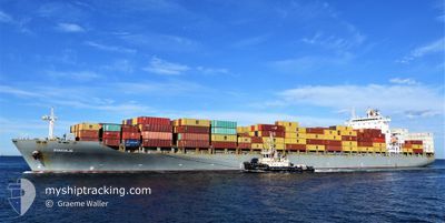
MSC DURBAN IV
Container Ship
Current Trip
| Time Travelled | 4 days |
|---|---|
| Remaining Time | --- |
| Distance Travelled | 1374.69 nm |
| Remaining Distance | --- |
| AVG Speed | 13.9 Knots |
| MAX Speed | 16.7 Knots |
| AVG Wind | 9.4 knots |
| MAX Wind | 22.5 knots |
| MIN Temp | 13.7°C / 56.66°F |
| MAX Temp | 29.3°C / 84.74°F |
| Draught | 9.2 m |
| Position Received | 1 d ago |
Current Position
| Longitude | 117.80132° |
|---|---|
| Latitude | 23.34576° |
| Status | Under way using engine |
| Speed | 15.5 Knots |
| Course | 214.1° |
| Area | South China Sea |
| Station | T-AIS |
| Position Received | 1 d ago |
Info
Information
The current position of MSC DURBAN IV is in South China Sea with coordinates 23.34576° / 117.80132° as reported on 2024-04-23 19:21 by AIS to our vessel tracker app. The vessel's current speed is 15.5 Knots and is heading at the port of VUNG TAU. The estimated time of arrival as calculated by MyShipTracking vessel tracking app is 2024-04-26 05:00 LT
The vessel MSC DURBAN IV (IMO: 9294824, MMSI: 636015181) is a Container Ship that was built in 2006 ( 18 years old ). It's sailing under the flag of [LR] Liberia.
In this page you can find informations about the vessels current position, last detected port calls, and current voyage information. If the vessels is not in coverage by AIS you will find the latest position.
The current position of MSC DURBAN IV is detected by our AIS receivers and we are not responsible for the reliability of the data. The last position was recorded while the vessel was in Coverage by the Ais receivers of our vessel tracking app.
The current draught of MSC DURBAN IV as reported by AIS is 9.2 meters
Weather
| Temperature | 29.3°C / 84.74°F |
|---|---|
| Wind Speed | 13 knots |
| Direction | 173° S |
| Pressure | 1009.3 hPa |
| Humidity | 80.6 % |
| Cloud Coverage | 32 % |
Featured Company
Last Port Calls
| Port | Arrival | Departure | Time In Port |
|---|---|---|---|
| 2024-04-20 12:39 | 2024-04-21 01:35 | 12 h | |
| 2024-04-17 12:54 | 2024-04-18 06:34 | 17 h | |
| 2024-04-17 03:27 | 2024-04-17 12:11 | 8 h | |
| 2024-04-15 22:15 | 2024-04-16 10:37 | 12 h | |
| 2024-04-15 09:06 | 2024-04-15 20:39 | 11 h | |
| 2024-04-11 19:16 | 2024-04-12 14:21 | 19 h | |
| 2024-04-09 06:08 | 2024-04-09 09:56 | 3 h | |
| 2024-04-04 13:27 | 2024-04-04 21:54 | 8 h | |
| 2024-03-30 04:16 | 2024-03-31 05:40 | 1 d | |
| 2024-03-23 23:56 | 2024-03-24 23:32 | 23 h |
Last Trips
| Origin | Departure | Destination | Arrival | Distance | |
|---|---|---|---|---|---|
| 2024-04-18 15:34 | 2024-04-20 21:39 | 506.44 nm | |||
| 2024-04-17 21:11 | 2024-04-17 21:54 | 7.78 nm | |||
| 2024-04-16 19:37 | 2024-04-17 12:27 | 205.81 nm | |||
| 2024-04-16 05:39 | 2024-04-16 07:15 | 14.54 nm | |||
| 2024-04-12 23:21 | 2024-04-15 18:06 | 695.87 nm | |||
| 2024-04-09 17:56 | 2024-04-12 04:16 | 493.58 nm | |||
| 2024-04-05 05:54 | 2024-04-09 14:08 | 671.74 nm | |||
| 2024-03-31 13:40 | 2024-04-04 21:27 | 517.92 nm | |||
| 2024-03-25 07:32 | 2024-03-30 12:16 | 1337.86 nm | |||
| 2024-03-23 19:07 | 2024-03-24 07:56 | 15.96 nm |
Events
| Time | Event | Details | Position / Dest | Info |
|---|---|---|---|---|
| 2024-04-23 19:28 | Status Changed | Default Under way using engine |
23.31874 / 117.78239
VNVUT
|
Speed: 15.5 kn Course: 214.1° |
| 2024-04-23 19:21 | OUT of Coverage |
23.34576 / 117.80132
South China Sea
VNVUT
|
Speed: 15.5 kn Course: 214.1° |
|
| 2024-04-23 15:55 | Change Sea Area | Chinese part of the South China Sea South Korean part of the Japan Sea |
23.96414 / 118.49497
South China Sea
VNVUT
|
Speed: 14.8 kn Course: 216° |
| 2024-04-23 15:54 | Status Changed | Under way using engine Default |
23.96894 / 118.49917
VNVUT
|
Speed: 15.1 kn Course: 223° |
| 2024-04-23 15:44 | IN Coverage |
23.96414 / 118.49497
South China Sea
VNVUT
|
Speed: 14.8 kn Course: 216° |
|
| 2024-04-21 03:40 | Status Changed | Default Under way using engine |
34.71060 / 128.91138
VNVUT
|
Speed: 11.4 kn Course: 183.4° |
| 2024-04-21 03:34 | OUT of Coverage |
34.72931 / 128.91280
Japan Sea
VNVUT
|
Speed: 11.4 kn Course: 183.4° |
|
| 2024-04-21 02:44 | Draught Changed | 9.2 9.7 |
34.87936 / 128.89334
VNVUT
|
Speed: 11.1 kn Course: 156.8° |
| 2024-04-21 02:44 | Destination Changed | VNVUT KRPUS |
34.87936 / 128.89334
VNVUT
|
Speed: 11.1 kn Course: 156.8° |
| 2024-04-21 02:44 | ETA Changed | 2024/04/26 05:00 2024/04/20 12:00 |
34.87936 / 128.89334
VNVUT
|
Speed: 11.1 kn Course: 156.8° |