
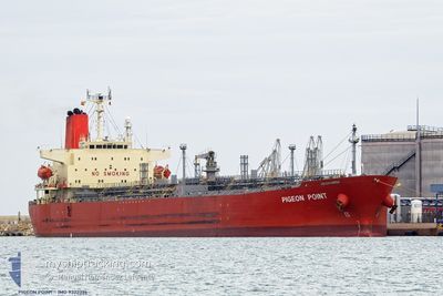
PIGEON POINT
Chemical Tanker
Current Trip
| Time Travelled | 2 days |
|---|---|
| Remaining Time | --- |
| Distance Travelled | 138.22 nm |
| Remaining Distance | --- |
| AVG Speed | 8.7 Knots |
| MAX Speed | 14.3 Knots |
| AVG Wind | 19.6 knots |
| MAX Wind | 29 knots |
| MIN Temp | 7.3°C / 45.14°F |
| MAX Temp | 10.1°C / 50.18°F |
| Draught | 8.7 m |
| Position Received | 1 m ago |
Current Position
| Longitude | 2.69382° |
|---|---|
| Latitude | 51.44725° |
| Status | At anchor |
| Speed | 0.1 Knots |
| Course | 324° |
| Area | North Sea |
| Station | T-AIS |
| Position Received | 1 m ago |
Info
Information
The current position of PIGEON POINT is in North Sea with coordinates 51.44725° / 2.69382° as reported on 2024-04-20 10:20 by AIS to our vessel tracker app. The vessel's current speed is 0.1 Knots
The vessel PIGEON POINT (IMO: 9322396, MMSI: 235077605) is a Chemical Tanker that was built in 2005 ( 19 years old ). It's sailing under the flag of [GB] United Kingdom.
In this page you can find informations about the vessels current position, last detected port calls, and current voyage information. If the vessels is not in coverage by AIS you will find the latest position.
The current position of PIGEON POINT is detected by our AIS receivers and we are not responsible for the reliability of the data. The last position was recorded while the vessel was in Coverage by the Ais receivers of our vessel tracking app.
The current draught of PIGEON POINT as reported by AIS is 8.7 meters
Weather
| Temperature | 7.6°C / 45.68°F |
|---|---|
| Wind Speed | 20 knots |
| Direction | 353° N |
| Pressure | 1025.7 hPa |
| Humidity | 63.3 % |
| Cloud Coverage | 99 % |
Featured Company
Last Port Calls
| Port | Arrival | Departure | Time In Port |
|---|---|---|---|
| 2024-04-16 19:08 | 2024-04-18 07:41 | 1 d | |
| 2024-04-06 10:18 | 2024-04-07 16:10 | 1 d | |
| 2024-03-21 12:41 | 2024-03-23 06:55 | 1 d | |
| 2024-03-03 08:19 | 2024-03-05 05:06 | 1 d | |
| 2024-02-29 21:31 | 2024-03-02 21:29 | 1 d | |
| 2024-02-09 03:16 | 2024-02-10 11:52 | 1 d |
Most Visited Ports (Last year)
| Port | Arrivals | |
|---|---|---|
| 4 | ||
| 2 | ||
| 2 | ||
| 2 | ||
| 2 | ||
| 1 |
Last Trips
| Origin | Departure | Destination | Arrival | Distance | |
|---|---|---|---|---|---|
| 2024-04-07 18:10 | 2024-04-16 21:08 | 1047.08 nm | |||
| 2024-03-23 02:55 | 2024-04-06 12:18 | 3782.75 nm | |||
| 2024-03-05 06:06 | 2024-03-21 08:41 | 4657.52 nm | |||
| 2024-03-02 22:29 | 2024-03-03 09:19 | 128.29 nm | |||
| 2024-02-10 07:52 | 2024-02-29 22:31 | 4719.54 nm | |||
| 2024-01-25 22:36 | 2024-02-08 23:16 | 4007.97 nm |
Events
| Time | Event | Details | Position / Dest | Info |
|---|---|---|---|---|
| 2024-04-19 07:32 | STOP Moving | 16.33 nm, North West of OOSTENDE |
51.45000 / 2.69735
BE GNE
|
Speed: 0.2 kn Course: 285° |
| 2024-04-19 06:02 | START Moving | 14.83 nm, North West of OOSTENDE |
51.39727 / 2.65887
BE GNE
|
Speed: 3.1 kn Course: 25° |
| 2024-04-18 19:41 | STOP Moving | 16.26 nm, North West of OOSTENDE |
51.40060 / 2.61213
BE GNE
|
Speed: Course: 224° |
| 2024-04-18 19:20 | Status Changed | At anchor Under way using engine |
51.39787 / 2.60838
BE GNE
|
Speed: 1.3 kn Course: 336° |
| 2024-04-18 16:50 | Change Sea Area | Belgian part of the North Sea French part of the North Sea |
51.32982 / 2.37373
North Sea
BE GNE
|
Speed: 11.9 kn Course: 65° |
| 2024-04-18 15:47 | Change Sea Area | French part of the North Sea United Kingdom part of the North Sea |
51.35187 / 2.05163
North Sea
BE GNE
|
Speed: 13.1 kn Course: 123° |
| 2024-04-18 14:05 | ETA Changed | 2024/04/18 20:00 2024/04/18 19:00 |
51.64677 / 2.28762
BE GNE
|
Speed: 13.5 kn Course: 221° |
| 2024-04-18 13:56 | Detected in Sea | United Kingdom part of the North Sea |
51.67173 / 2.32270
North Sea
BE GNE
|
Speed: 13.4 kn Course: 221° |
| 2024-04-18 12:53 | Change Sea Area | Belgian part of the North Sea Dutch part of the North Sea |
51.84475 / 2.56885
North Sea
BE GNE
|
Speed: 12.9 kn Course: 221° |
| 2024-04-18 11:18 | ETA Changed | 2024/04/18 19:00 2024/04/18 17:00 |
52.03098 / 2.98243
BE GNE
|
Speed: 12.7 kn Course: 264° |