
PATRICK C
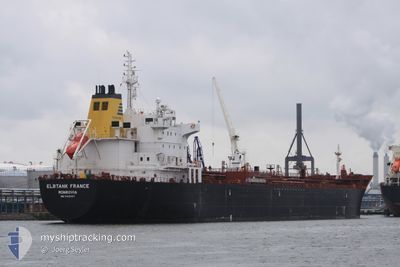
Oil/Chemical Tanker
Current Trip
| Time Travelled | 1 day |
|---|---|
| Remaining Time | --- |
| Distance Travelled | 147.08 nm |
| Remaining Distance | --- |
| AVG Speed | 8 Knots |
| MAX Speed | 15 Knots |
| AVG Wind | 6.8 knots |
| MAX Wind | 13.7 knots |
| MIN Temp | 15°C / 59°F |
| MAX Temp | 22°C / 71.6°F |
| Draught | 8 m |
| Position Received | 1 h, 6 m ago |
Current Position
| Longitude | 29.41520° |
|---|---|
| Latitude | 41.35445° |
| Status | Under way using engine |
| Speed | 12.2 Knots |
| Course | 55.9° |
| Area | Black Sea |
| Station | T-AIS |
| Position Received | 1 h, 6 m ago |
Info
Information
The current position of PATRICK C is in Black Sea with coordinates 41.35445° / 29.41520° as reported on 2024-04-25 15:32 by AIS to our vessel tracker app. The vessel's current speed is 12.2 Knots and is heading at the port of BATUMI. The estimated time of arrival as calculated by MyShipTracking vessel tracking app is 2024-04-27 06:00 LT
The vessel PATRICK C (IMO: 9425497, MMSI: 636016315) is a Oil/Chemical Tanker that was built in 2009 ( 15 years old ). It's sailing under the flag of [LR] Liberia.
In this page you can find informations about the vessels current position, last detected port calls, and current voyage information. If the vessels is not in coverage by AIS you will find the latest position.
The current position of PATRICK C is detected by our AIS receivers and we are not responsible for the reliability of the data. The last position was recorded while the vessel was in Coverage by the Ais receivers of our vessel tracking app.
The current draught of PATRICK C as reported by AIS is 8 meters
Weather
| Temperature | 15.6°C / 60.08°F |
|---|---|
| Wind Speed | 8 knots |
| Direction | 113° ESE |
| Pressure | 1003.8 hPa |
| Humidity | 83.2 % |
| Cloud Coverage | 63 % |
Featured Company
Most Visited Ports (Last year)
| Port | Arrivals | |
|---|---|---|
| 4 | ||
| 3 | ||
| 3 | ||
| 2 | ||
| 2 | ||
| 2 |
Events
| Time | Event | Details | Position / Dest | Info |
|---|---|---|---|---|
| 2024-04-25 15:40 | Status Changed | Default Under way using engine |
41.36808 / 29.44634
GEBUS
|
Speed: 12.2 kn Course: 55.9° |
| 2024-04-25 15:32 | OUT of Coverage |
41.35445 / 29.41520
Black Sea
GEBUS
|
Speed: 12.2 kn Course: 55.9° |
|
| 2024-04-25 14:51 | START Moving | 6.89 nm, North East of RUMELI FENERI |
41.28067 / 29.25060
GEBUS
|
Speed: 12.9 kn Course: 59.8° |
| 2024-04-25 14:50 | STOP Moving | 6.79 nm, North East of RUMELI FENERI |
41.27878 / 29.24949
GEBUS
|
Speed: Course: 59° |
| 2024-04-25 14:26 | Change Sea Area | Turkish part of the Black Sea Turkish part of the Sea of Marmara |
41.23282 / 29.15206
Black Sea
GEBUS
|
Speed: 13 kn Course: 40.3° |
| 2024-04-25 10:11 | Destination Changed | GEBUS TR IST |
40.77495 / 28.62664
GEBUS
|
Speed: 0.7 kn Course: 224° |
| 2024-04-25 10:11 | ETA Changed | 2024/04/27 06:00 2024/04/24 01:00 |
40.77495 / 28.62664
GEBUS
|
Speed: 0.7 kn Course: 224° |
| 2024-04-25 03:39 | Draught Changed | 8 6.7 |
40.80130 / 28.69042
TR IST
|
Speed: 6.4 kn Course: 229.6° |
| 2024-04-25 02:38 | START Moving | 3.02 nm, West of YESILKOY |
40.94212 / 28.76159
TR IST
|
Speed: 3.3 kn Course: 191° |
| 2024-04-25 02:29 | Status Changed | Under way using engine At anchor |
40.94503 / 28.76485
TR IST
|
Speed: 0.3 kn Course: 272° |