
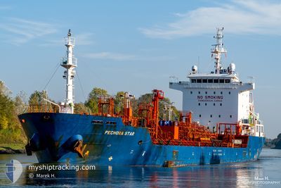
PECHORA STAR
Oil/Chemical Tanker
Current Trip
| Time Travelled | 3 days |
|---|---|
| Remaining Time | --- |
| Distance Travelled | 744.15 nm |
| Remaining Distance | 5.64 nm |
| AVG Speed | 9.1 Knots |
| MAX Speed | 11.5 Knots |
| AVG Wind | 20.7 knots |
| MAX Wind | 34.2 knots |
| MIN Temp | 7°C / 44.6°F |
| MAX Temp | 11.7°C / 53.06°F |
| Draught | 7.9 m |
| Position Received | 1 m ago |
Current Position
| Longitude | -1.27945° |
|---|---|
| Latitude | 46.07729° |
| Status | Under way using engine |
| Speed | 2.4 Knots |
| Course | 34° |
| Area | Bay of Biscay |
| Station | T-AIS |
| Position Received | 1 m ago |
Info
Information
The current position of PECHORA STAR is in Bay of Biscay with coordinates 46.07729° / -1.27945° as reported on 2024-04-18 11:46 by AIS to our vessel tracker app. The vessel's current speed is 2.4 Knots and is heading at the port of LA PALLICE. The estimated time of arrival as calculated by MyShipTracking vessel tracking app is 2024-04-18 07:00 LT
The vessel PECHORA STAR (IMO: 9488322, MMSI: 215760000) is a Oil/Chemical Tanker that was built in 2011 ( 13 years old ). It's sailing under the flag of [MT] Malta.
In this page you can find informations about the vessels current position, last detected port calls, and current voyage information. If the vessels is not in coverage by AIS you will find the latest position.
The current position of PECHORA STAR is detected by our AIS receivers and we are not responsible for the reliability of the data. The last position was recorded while the vessel was in Coverage by the Ais receivers of our vessel tracking app.
The current draught of PECHORA STAR as reported by AIS is 7.9 meters
Weather
| Temperature | 11°C / 51.8°F |
|---|---|
| Wind Speed | 12 knots |
| Direction | 16° NNE |
| Pressure | 1022.9 hPa |
| Humidity | 61.5 % |
| Cloud Coverage | 43 % |
Featured Company
Last Port Calls
| Port | Arrival | Departure | Time In Port |
|---|---|---|---|
| 2024-04-12 21:24 | 2024-04-15 04:02 | 2 d | |
| 2024-04-09 01:39 | 2024-04-10 04:50 | 1 d | |
| 2024-04-05 17:17 | 2024-04-07 00:42 | 1 d | |
| 2024-03-30 08:01 | 2024-03-31 03:07 | 19 h | |
| 2024-03-27 20:12 | 2024-03-29 07:45 | 1 d | |
| 2024-03-16 09:13 | 2024-03-17 15:12 | 1 d | |
| 2024-03-11 05:21 | 2024-03-13 12:28 | 2 d | |
| 2024-03-05 19:09 | 2024-03-07 19:39 | 2 d | |
| 2024-03-05 01:57 | 2024-03-05 02:38 | 40 m | |
| 2024-03-03 12:45 | 2024-03-05 01:05 | 1 d |
Last Trips
| Origin | Departure | Destination | Arrival | Distance | |
|---|---|---|---|---|---|
| 2024-04-10 06:50 | 2024-04-12 23:24 | 559.75 nm | |||
| 2024-04-07 02:42 | 2024-04-09 03:39 | 459.47 nm | |||
| 2024-03-31 04:07 | 2024-04-05 19:17 | 680.44 nm | |||
| 2024-03-29 07:45 | 2024-03-30 08:01 | 237.01 nm | |||
| 2024-03-17 16:12 | 2024-03-27 20:12 | 879.43 nm | |||
| 2024-03-13 13:28 | 2024-03-16 10:13 | 693.62 nm | |||
| 2024-03-07 20:39 | 2024-03-11 06:21 | 121.20 nm | |||
| 2024-03-05 03:38 | 2024-03-05 20:09 | 176.51 nm | |||
| 2024-03-05 02:05 | 2024-03-05 02:57 | 4.30 nm | |||
| 2024-03-02 04:36 | 2024-03-03 13:45 | 306.47 nm |
Events
| Time | Event | Details | Position / Dest | Info |
|---|---|---|---|---|
| 2024-04-18 11:41 | Status Changed | Under way using engine At anchor |
46.07545 / -1.28045
NL AMS>FR LPE
|
Speed: 0.2 kn Course: 353° |
| 2024-04-18 07:33 | STOP Moving | 5.31 nm, South of LA PALLICE |
46.07429 / -1.28086
NL AMS>FR LPE
|
Speed: 0.3 kn Course: 4° |
| 2024-04-18 07:30 | Status Changed | At anchor Under way using engine |
46.07447 / -1.28147
NL AMS>FR LPE
|
Speed: 0.7 kn Course: 23° |
| 2024-04-18 04:24 | Status Changed | Under way using engine Default |
46.23155 / -1.93065
NL AMS>FR LPE
|
Speed: 10 kn Course: 124° |
| 2024-04-18 04:06 | IN Coverage |
46.22779 / -1.92286
Bay of Biscay
NL AMS>FR LPE
|
Speed: 10.9 kn Course: 124.2° |
|
| 2024-04-18 03:06 | Status Changed | Default Under way using engine |
46.36666 / -2.20500
NL AMS>FR LPE
|
Speed: 10.7 kn Course: 124° |
| 2024-04-18 02:57 | OUT of Coverage |
46.38362 / -2.23844
Bay of Biscay
NL AMS>FR LPE
|
Speed: 10.7 kn Course: 124° |
|
| 2024-04-17 23:20 | ETA Changed | 2024/04/18 07:00 2024/04/18 04:00 |
46.77999 / -2.97677
NL AMS>FR LPE
|
Speed: 10.6 kn Course: 116.6° |
| 2024-04-17 22:58 | Status Changed | Under way using engine Default |
46.80919 / -3.06212
NL AMS>FR LPE
|
Speed: 10 kn Course: 131° |
| 2024-04-17 22:58 | IN Coverage |
46.80877 / -3.06083
Bay of Biscay
NL AMS>FR LPE
|
Speed: 10.6 kn Course: 114.7° |