
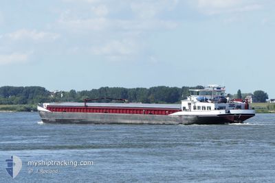
PANTA RHEI
Cargo
Current Trip
| Time Travelled | 13 h, 41 mins |
|---|---|
| Remaining Time | --- |
| Distance Travelled | 134.43 nm |
| Remaining Distance | --- |
| AVG Speed | 10.8 Knots |
| MAX Speed | 14 Knots |
| AVG Wind | 8.3 knots |
| MAX Wind | 16 knots |
| MIN Temp | 6.1°C / 42.98°F |
| MAX Temp | 12.1°C / 53.78°F |
| Draught | 0 m |
| Position Received | Now |
Current Position
| Longitude | 5.94130° |
|---|---|
| Latitude | 51.86923° |
| Status | Under way using engine |
| Speed | 10.4 Knots |
| Course | 322.2° |
| Area | North Sea |
| Station | T-AIS |
| Position Received | Now |
Info
Information
The current position of PANTA RHEI is in North Sea with coordinates 51.86923° / 5.94130° as reported on 2024-04-19 01:40 by AIS to our vessel tracker app. The vessel's current speed is 10.4 Knots and is heading at the port of ROESELARE. The estimated time of arrival as calculated by MyShipTracking vessel tracking app is 2024-04-20 07:47 LT
The vessel PANTA RHEI (MMSI: 244750541) is a Cargo It's sailing under the flag of [NL] Netherlands.
In this page you can find informations about the vessels current position, last detected port calls, and current voyage information. If the vessels is not in coverage by AIS you will find the latest position.
The current position of PANTA RHEI is detected by our AIS receivers and we are not responsible for the reliability of the data. The last position was recorded while the vessel was in Coverage by the Ais receivers of our vessel tracking app.
Weather
| Temperature | 6.5°C / 43.7°F |
|---|---|
| Wind Speed | 16 knots |
| Direction | 234° SW |
| Pressure | 1012.9 hPa |
| Humidity | 92.5 % |
| Cloud Coverage | 100 % |
Featured Company
Last Port Calls
| Port | Arrival | Departure | Time In Port |
|---|---|---|---|
| 2024-04-17 11:44 | 2024-04-18 12:00 | 1 d | |
| 2024-04-15 03:45 | 2024-04-16 14:08 | 1 d | |
| 2024-04-15 00:35 | 2024-04-15 01:00 | 25 m | |
| 2024-04-12 19:54 | 2024-04-15 00:31 | 2 d | |
| 2024-04-12 17:15 | 2024-04-12 17:33 | 17 m | |
| 2024-04-12 07:59 | 2024-04-12 08:06 | 7 m | |
| 2024-04-12 01:33 | 2024-04-12 02:54 | 1 h | |
| 2024-04-11 13:49 | 2024-04-11 21:19 | 7 h | |
| 2024-04-10 17:24 | 2024-04-10 18:51 | 1 h | |
| 2024-04-09 19:29 | 2024-04-09 19:53 | 24 m |
Last Trips
| Origin | Departure | Destination | Arrival | Distance | |
|---|---|---|---|---|---|
| 2024-04-16 16:08 | 2024-04-17 13:44 | 58.74 nm | |||
| 2024-04-15 03:00 | 2024-04-15 05:45 | 14.36 nm | |||
| 2024-04-15 02:31 | 2024-04-15 02:35 | 0.33 nm | |||
| 2024-04-12 19:33 | 2024-04-12 21:54 | 11.65 nm | |||
| 2024-04-12 10:06 | 2024-04-12 19:15 | 49.80 nm | |||
| 2024-04-12 04:54 | 2024-04-12 09:59 | 27.12 nm | |||
| 2024-04-11 23:19 | 2024-04-12 03:33 | 18.65 nm | |||
| 2024-04-10 20:51 | 2024-04-11 15:49 | 125.50 nm | |||
| 2024-04-09 21:53 | 2024-04-10 19:24 | 15.93 nm | |||
| 2024-04-09 19:31 | 2024-04-09 21:29 | 9.71 nm |
Events
| Time | Event | Details | Position / Dest | Info |
|---|---|---|---|---|
| 2024-04-19 00:14 | IN Coverage |
51.81551 / 6.27783
North Sea
ROESELARE
|
Speed: 10.8 kn Course: 305.3° |
|
| 2024-04-18 22:13 | OUT of Coverage |
51.59429 / 6.59850
North Sea
ROESELARE
|
Speed: 11.2 kn Course: 353.6° |
|
| 2024-04-18 13:37 | Destination Changed | ROESELARE AUTOBAHNBRUCKE ST S |
50.58441 / 7.21970
ROESELARE
|
Speed: 10.8 kn Course: 311.6° |
| 2024-04-18 13:37 | ETA Changed | 2024/04/20 07:47 2024/04/16 22:09 |
50.58441 / 7.21970
ROESELARE
|
Speed: 10.8 kn Course: 311.6° |
| 2024-04-18 12:53 | IN Coverage |
50.48270 / 7.33710
North Sea
|
Speed: 10.8 kn Course: 324.8° |
|
| 2024-04-18 12:00 | PORT DEPARTURE |
|
50.48270 / 7.33710
AUTOBAHNBRUCKE ST S
|
Speed: Course: -1° |
| 2024-04-17 11:45 | STOP Moving |
50.41667 / 7.56333
[DE] BENDORF
|
Speed: Course: -1° |
|
| 2024-04-17 11:44 | PORT ARRIVAL |
|
50.41667 / 7.56333
[DE] BENDORF
|
Speed: 3 kn Course: -1° |
| 2024-04-17 10:15 | Status Changed | Default Under way using engine |
50.42500 / 7.45167
AUTOBAHNBRUCKE ST S
|
Speed: 5.2 kn Course: 131.1° |
| 2024-04-17 09:33 | OUT of Coverage |
50.45260 / 7.37792
North Sea
|
Speed: 5.2 kn Course: 131.1° |