
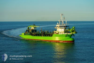
PALLIETER
Trailing Suction Hopper Dredger
Current Trip
SANTANDER
| Time Travelled | 9 days |
|---|---|
| Remaining Time | --- |
| Distance Travelled | 0.67 nm |
| Remaining Distance | --- |
| AVG Speed | 8.9 Knots |
| MAX Speed | 8.9 Knots |
| AVG Wind | 3.4 knots |
| MAX Wind | 3.6 knots |
| MIN Temp | 12.1°C / 53.78°F |
| MAX Temp | 12.2°C / 53.96°F |
| Draught | 4.3 m |
| Position Received | 9 d ago |
Current Position
| Longitude | -3.75381° |
|---|---|
| Latitude | 43.46784° |
| Status | Moored |
| Speed | 9.5 Knots |
| Course | 55.5° |
| Area | Bay of Biscay |
| Station | T-AIS |
| Position Received | 9 d ago |
Info
Information
The current position of PALLIETER is in Bay of Biscay with coordinates 43.46784° / -3.75381° as reported on 2024-04-10 09:39 by AIS to our vessel tracker app. The vessel's current speed is 9.5 Knots
The vessel PALLIETER (IMO: 9279123, MMSI: 205393000) is a Trailing Suction Hopper Dredger that was built in 2004 ( 20 years old ). It's sailing under the flag of [BE] Belgium.
In this page you can find informations about the vessels current position, last detected port calls, and current voyage information. If the vessels is not in coverage by AIS you will find the latest position.
The current position of PALLIETER is detected by our AIS receivers and we are not responsible for the reliability of the data. The last position was recorded while the vessel was in Coverage by the Ais receivers of our vessel tracking app.
The current draught of PALLIETER as reported by AIS is 4.3 meters
Weather
| Temperature | 12.3°C / 54.14°F |
|---|---|
| Wind Speed | 10 knots |
| Direction | 303° WNW |
| Pressure | 1024.4 hPa |
| Humidity | 69.5 % |
| Cloud Coverage | 100 % |
Featured Company
Last Port Calls
| Port | Arrival | Departure | Time In Port |
|---|---|---|---|
| 2024-04-08 11:53 | 2024-04-10 09:28 | 1 d | |
| 2024-04-04 13:07 | 2024-04-04 13:18 | 10 m | |
| 2024-02-01 08:04 | 2024-04-04 12:42 | ||
| 2024-02-01 07:33 | 2024-02-01 07:43 | 9 m |
Last Trips
| Origin | Departure | Destination | Arrival | Distance | |
|---|---|---|---|---|---|
| 2024-04-04 15:18 | 2024-04-08 13:53 | 39.15 nm | |||
| 2024-04-04 14:42 | 2024-04-04 15:07 | 1.73 nm | |||
| 2024-02-01 08:43 | 2024-02-01 09:04 | 1.82 nm | |||
| 2024-01-28 00:24 | 2024-02-01 08:33 | 751.05 nm |
Events
| Time | Event | Details | Position / Dest | Info |
|---|---|---|---|---|
| 2024-04-16 18:47 | STOP Moving | 2.09 nm, North East of SANTANDER |
43.48157 / -3.76985
SANTANDER
|
Speed: 0.3 kn Course: 325° |
| 2024-04-16 11:04 | STOP Moving | 2.1 nm, North East of SANTANDER |
43.48163 / -3.76958
SANTANDER
|
Speed: 0.3 kn Course: 309° |
| 2024-04-14 10:33 | STOP Moving | 2.08 nm, North East of SANTANDER |
43.48217 / -3.77103
SANTANDER
|
Speed: 0.1 kn Course: 59° |
| 2024-04-10 20:31 | STOP Moving | 2.1 nm, North East of SANTANDER |
43.48208 / -3.77050
SANTANDER
|
Speed: 0.2 kn Course: 1° |
| 2024-04-10 12:27 | STOP Moving | 2.09 nm, North East of SANTANDER |
43.48209 / -3.77067
SANTANDER
|
Speed: 0.3 kn Course: 26° |
| 2024-04-10 09:52 | Status Changed | Default Moored |
43.48157 / -3.77079
SANTANDER
|
Speed: 9.5 kn Course: 55.5° |
| 2024-04-10 09:39 | OUT of Coverage |
43.46784 / -3.75381
Bay of Biscay
|
Speed: 9.5 kn Course: 55.5° |
|
| 2024-04-10 09:28 | PORT DEPARTURE |
|
43.45884 / -3.78675
SANTANDER
|
Speed: 8.5 kn Course: 83° |
| 2024-04-10 09:26 | Status Changed | Moored Default |
43.45794 / -3.79315
[ES] SANTANDER
|
Speed: 8.2 kn Course: 78° |
| 2024-04-10 09:19 | START Moving |
43.44931 / -3.81059
[ES] SANTANDER
|
Speed: 8 kn Course: 31° |