
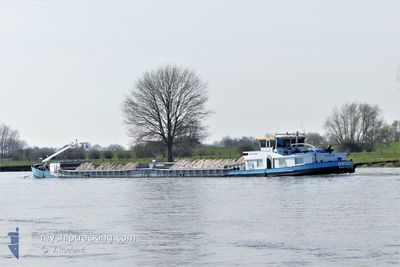
ORION
Cargo
Current Trip
SNITS
| Time Travelled | 11 h, 21 mins |
|---|---|
| Remaining Time | --- |
| Distance Travelled | 40.90 nm |
| Remaining Distance | --- |
| AVG Speed | 6.6 Knots |
| MAX Speed | 7.8 Knots |
| AVG Wind | 5.4 knots |
| MAX Wind | 8 knots |
| MIN Temp | 3.3°C / 37.94°F |
| MAX Temp | 5.1°C / 41.18°F |
| Draught | 2.7 m |
| Position Received | 2 m ago |
Current Position
| Longitude | --- |
|---|---|
| Latitude | --- |
| Status | Under way using engine |
| Speed | 6.3 Knots |
| Course | 62.7° |
| Area | North Sea |
| Station | T-AIS |
| Position Received | 2 m ago |
Info
Information
The current position of ORION is in North Sea with coordinates 52.27224° / 5.52802° as reported on 2024-12-13 05:59 by AIS to our vessel tracker app. The vessel's current speed is 6.3 Knots
The vessel ORION (MMSI: 244770601) is a Cargo It's sailing under the flag of [NL] Netherlands.
In this page you can find informations about the vessels current position, last detected port calls, and current voyage information. If the vessels is not in coverage by AIS you will find the latest position.
The current position of ORION is detected by our AIS receivers and we are not responsible for the reliability of the data. The last position was recorded while the vessel was in Coverage by the Ais receivers of our vessel tracking app.
The current draught of ORION as reported by AIS is 2.7 meters
Weather
| Temperature | 2.1°C / 35.78°F |
|---|---|
| Wind Speed | 5 knots |
| Direction | 98° E |
| Pressure | 1028.8 hPa |
| Humidity | 88.3 % |
| Cloud Coverage | 93 % |
Featured Company
Last Port Calls
| Port | Arrival | Departure | Time In Port |
|---|---|---|---|
| 2024-12-12 19:12 | 2024-12-12 19:41 | 29 m | |
| 2024-12-12 16:50 | 2024-12-12 17:35 | 45 m | |
| 2024-12-12 09:05 | 2024-12-12 12:20 | 3 h | |
| 2024-12-11 20:38 | 2024-12-12 08:10 | 11 h | |
| 2024-12-10 23:53 | 2024-12-11 11:19 | 11 h | |
| 2024-12-09 21:29 | 2024-12-10 13:51 | 16 h | |
| 2024-12-08 15:47 | 2024-12-09 13:54 | 22 h | |
| 2024-12-06 15:41 | 2024-12-08 09:12 | 1 d | |
| 2024-12-05 19:51 | 2024-12-06 11:48 | 15 h | |
| 2024-12-04 23:55 | 2024-12-05 12:17 | 12 h |
Last Trips
| Origin | Departure | Destination | Arrival | Distance | |
|---|---|---|---|---|---|
| 2024-12-12 17:35 | 2024-12-12 19:12 | 6.97 nm | |||
| 2024-12-12 12:20 | 2024-12-12 16:50 | 28.38 nm | |||
| 2024-12-12 08:10 | 2024-12-12 09:05 | 6.45 nm | |||
| 2024-12-11 11:19 | 2024-12-11 20:38 | 63.98 nm | |||
| 2024-12-10 13:51 | 2024-12-10 23:53 | 62.72 nm | |||
| 2024-12-09 13:54 | 2024-12-09 21:29 | 51.81 nm | |||
| 2024-12-08 09:12 | 2024-12-08 15:47 | 51.41 nm | |||
| 2024-12-06 11:48 | 2024-12-06 15:41 | 11.37 nm | |||
| 2024-12-05 12:17 | 2024-12-05 19:51 | 52.08 nm | |||
| 2024-12-03 12:13 | 2024-12-04 23:55 | 174.16 nm |
Events
| Time | Event | Details | Position / Dest | Info |
|---|---|---|---|---|
| 2024-12-13 05:39 | START Moving | 0.47 nm, North East of NIJKERK |
52.26245 / 5.47451
SNITS
|
Speed: 3.4 kn Course: 73.5° |
| 2024-12-13 05:25 | Status Changed | Under way using engine Moored |
52.26145 / 5.46804
SNITS
|
Speed: 0.3 kn Course: 511° |
| 2024-12-13 01:31 | Status Changed | Moored Under way using engine |
52.26142 / 5.46774
SNITS
|
Speed: Course: 511° |
| 2024-12-13 01:11 | STOP Moving | 0.27 nm, North of NIJKERK |
52.26134 / 5.46777
SNITS
|
Speed: 0.3 kn Course: 511° |
| 2024-12-12 21:45 | START Moving | 0.15 nm, South West of SCHELLINGWOUDE |
52.37963 / 4.96131
SNITS
|
Speed: 3.3 kn Course: 114° |
| 2024-12-12 21:14 | STOP Moving | 0.35 nm, West of SCHELLINGWOUDE |
52.38018 / 4.95510
SNITS
|
Speed: 0.3 kn Course: 511° |
| 2024-12-12 18:41 | PORT DEPARTURE |
|
52.12370 / 5.05940
SNITS
|
Speed: 7 kn Course: 313.6° |
| 2024-12-12 18:12 | PORT ARRIVAL |
|
52.07261 / 5.08663
[NL] UTRECHT
|
Speed: 7.1 kn Course: 331° |
| 2024-12-12 17:15 | IN Coverage |
52.00011 / 5.20748
North Sea
|
Speed: 6.9 kn Course: 295.2° |
|
| 2024-12-12 15:50 | OUT of Coverage |
51.96626 / 5.32615
North Sea
[NL] WIJK BIJ DUURSTEDE
|
Speed: 0.2 kn Course: 295.3° |