
OPTIMAR
General Cargo
Current Trip
| Time Travelled | 18 h, 6 mins |
|---|---|
| Remaining Time | 23 h, 13 mins |
| Distance Travelled | 183.65 nm |
| Remaining Distance | 226.55 nm |
| AVG Speed | 10.1 Knots |
| MAX Speed | 11.1 Knots |
| AVG Wind | 24.5 knots |
| MAX Wind | 27 knots |
| MIN Temp | -2.2°C / 28.04°F |
| MAX Temp | -0.4°C / 31.28°F |
| Draught | 4.8 m |
| Position Received | 1 m ago |
Current Position
| Longitude | 19.00141° |
|---|---|
| Latitude | 60.30097° |
| Status | Under way using engine |
| Speed | 10.1 Knots |
| Course | 179.6° |
| Area | Gulf of Bothnia |
| Station | T-AIS |
| Position Received | 1 m ago |
Info
Information
The current position of OPTIMAR is in Gulf of Bothnia with coordinates 60.30097° / 19.00141° as reported on 2024-04-20 10:01 by AIS to our vessel tracker app. The vessel's current speed is 10.1 Knots and is heading at the port of OSKARSHAMN. The estimated time of arrival as calculated by MyShipTracking vessel tracking app is 2024-04-21 09:15 LT
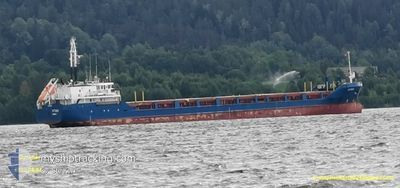
The vessel OPTIMAR (IMO: 9199402, MMSI: 209730000) is a General Cargo that was built in 2000 ( 24 years old ). It's sailing under the flag of [CY] Cyprus.
In this page you can find informations about the vessels current position, last detected port calls, and current voyage information. If the vessels is not in coverage by AIS you will find the latest position.
The current position of OPTIMAR is detected by our AIS receivers and we are not responsible for the reliability of the data. The last position was recorded while the vessel was in Coverage by the Ais receivers of our vessel tracking app.
The current draught of OPTIMAR as reported by AIS is 4.8 meters
Weather
| Temperature | -0.4°C / 31.28°F |
|---|---|
| Wind Speed | 26 knots |
| Direction | 359° N |
| Pressure | 1011 hPa |
| Humidity | 70.2 % |
| Cloud Coverage | 100 % |
Featured Company
Last Port Calls
| Port | Arrival | Departure | Time In Port |
|---|---|---|---|
| 2024-04-17 12:28 | 2024-04-19 15:56 | 2 d | |
| 2024-04-12 05:16 | 2024-04-12 20:30 | 15 h | |
| 2024-04-06 20:24 | 2024-04-08 22:09 | 2 d | |
| 2024-04-05 04:21 | 2024-04-06 06:33 | 1 d | |
| 2024-04-02 03:24 | 2024-04-02 18:13 | 14 h | |
| 2024-04-01 05:29 | 2024-04-01 18:09 | 12 h | |
| 2024-03-29 05:21 | 2024-03-30 03:34 | 22 h | |
| 2024-03-27 05:33 | 2024-03-27 19:05 | 13 h | |
| 2024-03-24 14:24 | 2024-03-25 12:33 | 22 h | |
| 2024-03-20 07:41 | 2024-03-22 20:12 | 2 d |
Last Trips
| Origin | Departure | Destination | Arrival | Distance | |
|---|---|---|---|---|---|
| 2024-04-12 23:30 | 2024-04-17 14:28 | 436.57 nm | |||
| 2024-04-09 01:09 | 2024-04-12 08:16 | 598.53 nm | |||
| 2024-04-06 08:33 | 2024-04-06 23:24 | 124.04 nm | |||
| 2024-04-02 21:13 | 2024-04-05 06:21 | 426.32 nm | |||
| 2024-04-01 21:09 | 2024-04-02 06:24 | 76.88 nm | |||
| 2024-03-30 05:34 | 2024-04-01 08:29 | 404.90 nm | |||
| 2024-03-27 21:05 | 2024-03-29 07:21 | 371.95 nm | |||
| 2024-03-25 13:33 | 2024-03-27 07:33 | 467.95 nm | |||
| 2024-03-22 22:12 | 2024-03-24 15:24 | 441.64 nm | |||
| 2024-03-19 09:40 | 2024-03-20 09:41 | 265.25 nm |
Events
| Time | Event | Details | Position / Dest | Info |
|---|---|---|---|---|
| 2024-04-20 09:42 | Draught Changed | 4.8 4.7 |
60.35153 / 18.99386
SEOSK
|
Speed: 9.8 kn Course: 175.6° |
| 2024-04-20 09:42 | Destination Changed | SEOSK SEHUS |
60.35153 / 18.99386
SEOSK
|
Speed: 9.8 kn Course: 175.6° |
| 2024-04-20 09:42 | ETA Changed | 2024/04/21 08:00 2024/04/14 10:00 |
60.35153 / 18.99386
SEOSK
|
Speed: 9.8 kn Course: 175.6° |
| 2024-04-20 09:12 | Status Changed | Under way using engine Default |
60.43421 / 18.98363
SEHUS
|
Speed: 10.5 kn Course: 175° |
| 2024-04-20 09:04 | Status Changed | Default Under way using engine |
60.45508 / 18.98167
SEHUS
|
Speed: 9.7 kn Course: 179.6° |
| 2024-04-20 08:51 | Status Changed | Under way using engine Default |
60.49111 / 18.97608
SEHUS
|
Speed: 9.7 kn Course: 181° |
| 2024-04-20 08:40 | IN Coverage |
60.48698 / 18.97671
Gulf of Bothnia
|
Speed: 9.1 kn Course: 172.3° |
|
| 2024-04-19 19:48 | Status Changed | Default Under way using engine |
62.71101 / 19.03577
SEHUS
|
Speed: 10.6 kn Course: 187.3° |
| 2024-04-19 19:41 | Status Changed | Under way using engine Default |
62.73169 / 19.03953
SEHUS
|
Speed: 10.5 kn Course: 186° |
| 2024-04-19 19:41 | OUT of Coverage |
62.73169 / 19.03953
Gulf of Bothnia
|
Speed: 10.6 kn Course: 187.3° |