
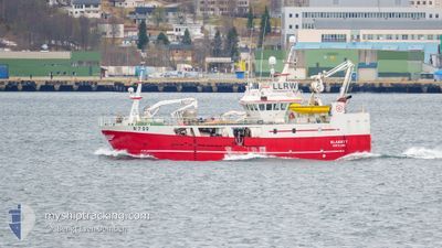
OLAGUTT
Fishing Vessel
Current Trip
TLF 90294801
| Time Travelled | 3 days |
|---|---|
| Remaining Time | --- |
| Distance Travelled | 42.32 nm |
| Remaining Distance | --- |
| AVG Speed | 7.9 Knots |
| MAX Speed | 10 Knots |
| AVG Wind | 6.7 knots |
| MAX Wind | 9.8 knots |
| MIN Temp | 0.3°C / 32.54°F |
| MAX Temp | 3.2°C / 37.76°F |
| Draught | 0 m |
| Position Received | 1 m ago |
Current Position
| Longitude | 15.52033° |
|---|---|
| Latitude | 68.64219° |
| Status | Engaged in Fishing |
| Speed | |
| Course | 268° |
| Area | Norwegian Sea |
| Station | T-AIS |
| Position Received | 1 m ago |
Info
Information
The current position of OLAGUTT is in Norwegian Sea with coordinates 68.64219° / 15.52033° as reported on 2024-04-25 19:19 by AIS to our vessel tracker app. The vessel's current speed is 0 Knots
The vessel OLAGUTT (IMO: 9025883, MMSI: 257576600) is a Fishing Vessel that was built in 2001 ( 23 years old ). It's sailing under the flag of [NO] Norway.
In this page you can find informations about the vessels current position, last detected port calls, and current voyage information. If the vessels is not in coverage by AIS you will find the latest position.
The current position of OLAGUTT is detected by our AIS receivers and we are not responsible for the reliability of the data. The last position was recorded while the vessel was in Coverage by the Ais receivers of our vessel tracking app.
Weather
| Temperature | 2°C / 35.6°F |
|---|---|
| Wind Speed | 2 knots |
| Direction | 115° ESE |
| Pressure | 1011.7 hPa |
| Humidity | 65.9 % |
| Cloud Coverage | 10 % |
Featured Company
Last Port Calls
| Port | Arrival | Departure | Time In Port |
|---|---|---|---|
| 2024-04-22 04:26 | 2024-04-22 08:52 | 4 h | |
| 2024-04-19 06:32 | 2024-04-19 14:17 | 7 h | |
| 2024-04-16 17:32 | 2024-04-17 02:32 | 8 h | |
| 2024-04-15 04:42 | 2024-04-15 06:43 | 2 h | |
| 2024-04-13 08:48 | 2024-04-13 11:25 | 2 h | |
| 2024-04-12 17:00 | 2024-04-13 03:08 | 10 h | |
| 2024-04-11 11:24 | 2024-04-12 02:17 | 14 h | |
| 2024-04-08 05:13 | 2024-04-08 08:07 | 2 h | |
| 2024-04-05 08:22 | 2024-04-05 11:04 | 2 h | |
| 2024-04-04 15:45 | 2024-04-04 16:39 | 54 m |
Last Trips
| Origin | Departure | Destination | Arrival | Distance | |
|---|---|---|---|---|---|
| 2024-04-19 16:17 | 2024-04-22 06:26 | 432.45 nm | |||
| 2024-04-17 04:32 | 2024-04-19 08:32 | 114.98 nm | |||
| 2024-04-15 08:43 | 2024-04-16 19:32 | 226.79 nm | |||
| 2024-04-13 13:25 | 2024-04-15 06:42 | 105.48 nm | |||
| 2024-04-13 05:08 | 2024-04-13 10:48 | 25.13 nm | |||
| 2024-04-12 04:17 | 2024-04-12 19:00 | 59.29 nm | |||
| 2024-04-08 10:07 | 2024-04-11 13:24 | 346.37 nm | |||
| 2024-04-05 13:04 | 2024-04-08 07:13 | 410.82 nm | |||
| 2024-04-04 18:39 | 2024-04-05 10:22 | 116.73 nm | |||
| 2024-03-16 07:27 | 2024-04-04 17:45 | 709.61 nm |
Events
| Time | Event | Details | Position / Dest | Info |
|---|---|---|---|---|
| 2024-04-22 14:49 | STOP Moving | 3.92 nm, South East of SORTLAND |
68.64217 / 15.52050
TLF 90294801
|
Speed: Course: 269° |
| 2024-04-22 13:48 | START Moving | 3.95 nm, South East of SORTLAND |
68.63997 / 15.51339
TLF 90294801
|
Speed: 5.7 kn Course: 226.4° |
| 2024-04-22 13:34 | STOP Moving | 3.91 nm, South East of SORTLAND |
68.64217 / 15.51995
TLF 90294801
|
Speed: Course: 267° |
| 2024-04-22 08:52 | PORT DEPARTURE |
|
68.91742 / 15.03347
TLF 90294801
|
Speed: 8.6 kn Course: 281° |
| 2024-04-22 08:46 | START Moving |
68.91285 / 15.06936
[NO] MYRE
|
Speed: 5.5 kn Course: 299° |
|
| 2024-04-22 04:36 | STOP Moving |
68.91223 / 15.07700
[NO] MYRE
|
Speed: 0.1 kn Course: 295° |
|
| 2024-04-22 04:26 | PORT ARRIVAL |
|
68.91414 / 15.05172
[NO] MYRE
|
Speed: 8 kn Course: 58.9° |
| 2024-04-22 03:55 | START Moving | 1.72 nm, South of MYRE |
68.88365 / 15.06923
TLF 90294801
|
Speed: 6.2 kn Course: 310.1° |
| 2024-04-22 01:58 | STOP Moving | 1.89 nm, South of MYRE |
68.88088 / 15.07095
TLF 90294801
|
Speed: Course: 25° |
| 2024-04-20 17:03 | START Moving | 21.26 nm, North West of HAVOYSUND |
71.19713 / 23.77407
TLF 90294801
|
Speed: 3.3 kn Course: 229° |