
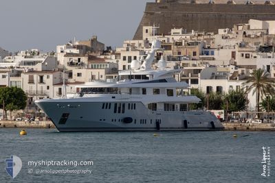
ODESSA II
Yacht
Current Trip
| Trip Time | 16 days |
|---|---|
| Trip Distance | 1765.66 nm |
| AVG Speed | 14.3 Knots |
| MAX Speed | 17.7 Knots |
| Draught | 3.6 m |
| AVG Wind | 11.6 knots |
| MAX Wind | 26 knots |
| MIN Temp | 10.6°C / 51.08°F |
| MAX Temp | 19.5°C / 67.1°F |
| Position Received | 6 h, 52 m ago |
Current Position
| Longitude | 14.44148° |
|---|---|
| Latitude | 45.32530° |
| Status | Moored |
| Speed | |
| Course | 30° |
| Area | Adriatic Sea |
| Station | T-AIS |
| Position Received | 6 h, 52 m ago |
Info
Information
The current position of ODESSA II is in Adriatic Sea with coordinates 45.32530° / 14.44148° as reported on 2024-04-25 05:09 by AIS to our vessel tracker app. The vessel's current speed is 0 Knots and is currently inside the port of RIJEKA.
The vessel ODESSA II (IMO: 9645671, MMSI: 538070951) is a Yacht that was built in 2013 ( 11 years old ). It's sailing under the flag of [MH] Marshall Is.
In this page you can find informations about the vessels current position, last detected port calls, and current voyage information. If the vessels is not in coverage by AIS you will find the latest position.
The current position of ODESSA II is detected by our AIS receivers and we are not responsible for the reliability of the data. The last position was recorded while the vessel was in Coverage by the Ais receivers of our vessel tracking app.
The current draught of ODESSA II as reported by AIS is 3.6 meters
Weather
| Temperature | 5.2°C / 41.36°F |
|---|---|
| Wind Speed | 8 knots |
| Direction | 40° NE |
| Pressure | 1008.9 hPa |
| Humidity | 89.7 % |
| Cloud Coverage | 99 % |
Featured Company
Last Port Calls
| Port | Arrival | Departure | Time In Port |
|---|---|---|---|
| 2024-04-21 17:23 | |||
| 2024-04-05 05:47 | 2024-04-05 15:55 | 10 h | |
| 2024-03-21 17:07 | 2024-03-25 14:54 | 3 d | |
| 2024-03-11 10:55 | 2024-03-13 11:53 | 2 d | |
| 2024-02-29 13:46 | 2024-03-11 03:10 | 10 d | |
| 2024-02-15 21:57 | 2024-02-29 12:17 | 13 d | |
| 2024-02-05 16:27 | 2024-02-09 11:48 | 3 d | |
| 2024-02-04 22:13 |
Last Trips
| Origin | Departure | Destination | Arrival | Distance | |
|---|---|---|---|---|---|
| 2024-04-05 17:55 | 2024-04-21 19:23 | 1765.66 nm | |||
| 2024-03-25 10:54 | 2024-04-05 07:47 | 3197.91 nm | |||
| 2024-03-10 23:10 | 2024-03-11 06:55 | 100.65 nm | |||
| 2024-02-29 08:17 | 2024-02-29 09:46 | 14.72 nm | |||
| 2024-02-09 07:48 | 2024-02-15 17:57 | 206.48 nm | |||
| 2024-02-04 18:13 | 2024-02-05 12:27 | 97.18 nm |
Events
| Time | Event | Details | Position / Dest | Info |
|---|---|---|---|---|
| 2024-04-25 05:09 | OUT of Coverage |
45.32530 / 14.44148
Adriatic Sea
[HR] RIJEKA
|
Speed: Course: 29.5° |
|
| 2024-04-25 05:09 | IN Coverage |
45.32530 / 14.44148
Adriatic Sea
[HR] RIJEKA
|
Speed: Course: 29.5° |
|
| 2024-04-21 17:40 | OUT of Coverage |
45.32515 / 14.44100
Adriatic Sea
[HR] RIJEKA
|
Speed: 0.3 kn Course: 68.7° |
|
| 2024-04-21 17:40 | STOP Moving |
45.32515 / 14.44100
[HR] RIJEKA
|
Speed: 0.3 kn Course: 62° |
|
| 2024-04-21 17:23 | PORT ARRIVAL |
|
45.32788 / 14.42170
[HR] RIJEKA
|
Speed: 5.8 kn Course: 71.3° |
| 2024-04-21 16:42 | Destination Changed | HRRJK ITVCE |
45.21322 / 14.32345
HRRJK
|
Speed: 14.3 kn Course: 29.8° |
| 2024-04-21 16:42 | ETA Changed | 2024/04/22 00:00 2024/04/13 16:30 |
45.21322 / 14.32345
HRRJK
|
Speed: 14.3 kn Course: 29.8° |
| 2024-04-21 15:54 | IN Coverage |
45.03593 / 14.24158
Adriatic Sea
|
Speed: 14.7 kn Course: 6.1° |
|
| 2024-04-21 11:46 | OUT of Coverage |
44.95260 / 13.25045
Adriatic Sea
|
Speed: 17.6 kn Course: 140.2° |
|
| 2024-04-21 10:36 | Detected in Sea | Croatian part of the Adriatic Sea |
45.20302 / 13.04592
Adriatic Sea
|
Speed: 14.3 kn Course: 160.4° |