
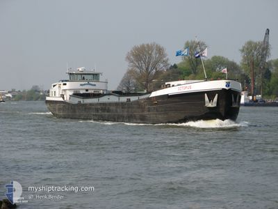
OCTOPUS
Cargo
Current Trip
| Trip Time | 8 days |
|---|---|
| Trip Distance | 17.39 nm |
| AVG Speed | 6.3 Knots |
| MAX Speed | 8.7 Knots |
| Draught | 0.2 m |
| AVG Wind | 6.7 knots |
| MAX Wind | 8.9 knots |
| MIN Temp | 4°C / 39.2°F |
| MAX Temp | 12.7°C / 54.86°F |
| Position Received | Now |
Current Position
| Longitude | 4.71528° |
|---|---|
| Latitude | 51.82797° |
| Status | Under way using engine |
| Speed | |
| Course | --- |
| Area | North Sea |
| Station | T-AIS |
| Position Received | Now |
Info
Information
The current position of OCTOPUS is in North Sea with coordinates 51.82797° / 4.71528° as reported on 2024-04-18 23:39 by AIS to our vessel tracker app. The vessel's current speed is 0 Knots and is currently inside the port of PAPENDRECHT.
The vessel OCTOPUS (MMSI: 244740078) is a Cargo It's sailing under the flag of [NL] Netherlands.
In this page you can find informations about the vessels current position, last detected port calls, and current voyage information. If the vessels is not in coverage by AIS you will find the latest position.
The current position of OCTOPUS is detected by our AIS receivers and we are not responsible for the reliability of the data. The last position was recorded while the vessel was in Coverage by the Ais receivers of our vessel tracking app.
The current draught of OCTOPUS as reported by AIS is 0.2 meters
Weather
| Temperature | 7.2°C / 44.96°F |
|---|---|
| Wind Speed | 15 knots |
| Direction | 234° SW |
| Pressure | 1015.5 hPa |
| Humidity | 88.8 % |
| Cloud Coverage | 100 % |
Featured Company
Last Port Calls
| Port | Arrival | Departure | Time In Port |
|---|---|---|---|
| 2024-04-18 09:57 | |||
| 2024-04-09 23:35 | 2024-04-10 09:56 | 10 h | |
| 2024-04-09 15:26 | 2024-04-09 15:55 | 29 m | |
| 2024-04-05 12:04 | 2024-04-05 12:20 | 16 m | |
| 2024-04-04 16:29 | 2024-04-05 10:51 | 18 h | |
| 2024-04-04 13:14 | 2024-04-04 13:59 | 44 m | |
| 2024-04-03 23:01 | 2024-04-04 04:19 | 5 h | |
| 2024-03-28 23:46 | 2024-03-29 13:31 | 13 h | |
| 2024-03-27 03:08 | 2024-03-27 11:55 | 8 h | |
| 2024-03-25 21:14 | 2024-03-25 21:19 | 4 m |
Last Trips
| Origin | Departure | Destination | Arrival | Distance | |
|---|---|---|---|---|---|
| 2024-04-10 11:56 | 2024-04-18 11:57 | 17.39 nm | |||
| 2024-04-09 17:55 | 2024-04-10 01:35 | 63.99 nm | |||
| 2024-04-05 14:20 | 2024-04-09 17:26 | 104.14 nm | |||
| 2024-04-05 12:51 | 2024-04-05 14:04 | 6.96 nm | |||
| 2024-04-04 15:59 | 2024-04-04 18:29 | 8.89 nm | |||
| 2024-04-04 06:19 | 2024-04-04 15:14 | 63.72 nm | |||
| 2024-03-29 14:31 | 2024-04-04 01:01 | 160.84 nm | |||
| 2024-03-27 12:55 | 2024-03-29 00:46 | 116.13 nm | |||
| 2024-03-25 22:19 | 2024-03-27 04:08 | 95.51 nm | |||
| 2024-03-25 11:32 | 2024-03-25 22:14 | 73.86 nm |
Events
| Time | Event | Details | Position / Dest | Info |
|---|---|---|---|---|
| 2024-04-18 09:57 | STOP Moving |
51.82770 / 4.71292
[NL] PAPENDRECHT
|
Speed: 0.2 kn Course: 511° |
|
| 2024-04-18 09:57 | PORT ARRIVAL |
|
51.82768 / 4.71289
[NL] PAPENDRECHT
|
Speed: 0.9 kn Course: 511° |
| 2024-04-18 08:35 | START Moving | 0.28 nm, North West of KRIMPEN |
51.91147 / 4.57051
WESEL
|
Speed: 4.6 kn Course: 230.7° |
| 2024-04-18 06:26 | STOP Moving | 0.32 nm, North West of KRIMPEN |
51.91313 / 4.57217
WESEL
|
Speed: Course: 511° |
| 2024-04-18 05:53 | START Moving | 0.02 nm, North West of OUDERKERK AAN DEN IJ |
51.93650 / 4.63326
WESEL
|
Speed: 4.9 kn Course: 257.4° |
| 2024-04-16 12:08 | IN Coverage |
51.93746 / 4.63612
North Sea
|
Speed: Course: 0° |
|
| 2024-04-15 16:42 | OUT of Coverage |
51.93744 / 4.63598
North Sea
|
Speed: Course: 0° |
|
| 2024-04-10 10:58 | STOP Moving | 0.11 nm, North East of OUDERKERK AAN DEN IJ |
51.93740 / 4.63595
WESEL
|
Speed: 0.3 kn Course: 511° |
| 2024-04-10 10:45 | START Moving | 1.04 nm, North of OUDERKERK AAN DEN IJ |
51.95257 / 4.64244
WESEL
|
Speed: 5.2 kn Course: 246.4° |
| 2024-04-10 10:32 | STOP Moving | 1.09 nm, North East of OUDERKERK AAN DEN IJ |
51.95286 / 4.64537
WESEL
|
Speed: 0.2 kn Course: 511° |