
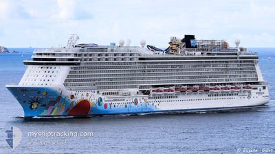
NORWEGIAN BREAKAWAY
Passengers Ship
Current Trip
LAST UPDATE TIME
| Time Travelled | 12 h, 42 mins |
|---|---|
| Remaining Time | --- |
| Distance Travelled | 251.47 nm |
| Remaining Distance | --- |
| AVG Speed | 20.5 Knots |
| MAX Speed | 21 Knots |
| AVG Wind | 10.7 knots |
| MAX Wind | 13 knots |
| MIN Temp | 26.2°C / 79.16°F |
| MAX Temp | 26.8°C / 80.24°F |
| Draught | 8.6 m |
| Position Received | 1 d ago |
Current Position
| Longitude | -71.75893° |
|---|---|
| Latitude | 20.65116° |
| Status | Under way using engine |
| Speed | 18.6 Knots |
| Course | 124° |
| Area | North Atlantic Ocean |
| Station | T-AIS |
| Position Received | 1 d ago |
Info
Information
The current position of NORWEGIAN BREAKAWAY is in North Atlantic Ocean with coordinates 20.65116° / -71.75893° as reported on 2024-04-23 04:56 by AIS to our vessel tracker app. The vessel's current speed is 18.6 Knots
The vessel NORWEGIAN BREAKAWAY (IMO: 9606912, MMSI: 311050800) is a Passengers Ship that was built in 2013 ( 11 years old ). It's sailing under the flag of [BS] Bahamas.
In this page you can find informations about the vessels current position, last detected port calls, and current voyage information. If the vessels is not in coverage by AIS you will find the latest position.
The current position of NORWEGIAN BREAKAWAY is detected by our AIS receivers and we are not responsible for the reliability of the data. The last position was recorded while the vessel was in Coverage by the Ais receivers of our vessel tracking app.
The current draught of NORWEGIAN BREAKAWAY as reported by AIS is 8.6 meters
Weather
| Temperature | 26.5°C / 79.7°F |
|---|---|
| Wind Speed | 10 knots |
| Direction | 84° E |
| Pressure | 1014.1 hPa |
| Humidity | 81.4 % |
| Cloud Coverage | 100 % |
Featured Company
Last Port Calls
| Port | Arrival | Departure | Time In Port |
|---|---|---|---|
| 2024-04-23 10:44 | 2024-04-23 20:17 | 9 h | |
| 2024-04-21 07:56 | 2024-04-21 21:59 | 14 h | |
| 2024-04-18 09:13 | 2024-04-18 18:22 | 9 h | |
| 2024-04-17 16:06 | 2024-04-17 23:58 | 7 h | |
| 2024-04-16 10:23 | 2024-04-16 20:21 | 9 h | |
| 2024-04-14 12:36 | 2024-04-14 21:48 | 9 h | |
| 2024-04-14 07:57 | 2024-04-14 12:29 | 4 h | |
| 2024-04-11 11:49 | 2024-04-11 23:19 | 11 h | |
| 2024-04-09 11:14 | 2024-04-09 20:35 | 9 h | |
| 2024-04-07 08:55 | 2024-04-07 20:03 | 11 h |
Most Visited Ports (Last year)
| Port | Arrivals | |
|---|---|---|
| 20 | ||
| 20 | ||
| 19 | ||
| 19 | ||
| 18 | ||
| 18 |
Last Trips
| Origin | Departure | Destination | Arrival | Distance | |
|---|---|---|---|---|---|
| 2024-04-21 17:59 | 2024-04-23 06:44 | 690.66 nm | |||
| 2024-04-18 14:22 | 2024-04-21 03:56 | 996.83 nm | |||
| 2024-04-17 19:58 | 2024-04-18 05:13 | 100.74 nm | |||
| 2024-04-16 16:21 | 2024-04-17 12:06 | 374.22 nm | |||
| 2024-04-14 17:48 | 2024-04-16 06:23 | 692.97 nm | |||
| 2024-04-14 08:29 | 2024-04-14 08:36 | 2.62 nm | |||
| 2024-04-11 18:19 | 2024-04-14 03:57 | 769.65 nm | |||
| 2024-04-09 16:35 | 2024-04-11 06:49 | 523.21 nm | |||
| 2024-04-07 15:03 | 2024-04-09 07:14 | 758.35 nm | |||
| 2024-04-05 14:59 | 2024-04-07 03:55 | 735.32 nm |
Events
| Time | Event | Details | Position / Dest | Info |
|---|---|---|---|---|
| 2024-04-23 20:17 | PORT DEPARTURE |
|
19.81543 / -70.68861
LAST UPDATE TIME
|
Speed: 3.5 kn Course: 26° |
| 2024-04-23 10:44 | STOP Moving |
19.80355 / -70.69955
[DO] PUERTO PLATA
|
Speed: Course: 16° |
|
| 2024-04-23 10:44 | PORT ARRIVAL |
|
19.80355 / -70.69955
[DO] PUERTO PLATA
|
Speed: 2.5 kn Course: 39° |
| 2024-04-23 05:04 | Status Changed | Default Under way using engine |
20.62702 / -71.72250
LAST UPDATE TIME
|
Speed: 18.6 kn Course: 124° |
| 2024-04-23 04:56 | OUT of Coverage |
20.65116 / -71.75893
North Atlantic Ocean
|
Speed: 18.6 kn Course: 124° |
|
| 2024-04-23 03:42 | Change Sea Area | Turks and Caicos part of the North Atlantic Ocean Bahamas part of the North Atlantic Ocean |
20.88807 / -72.08124
North Atlantic Ocean
|
Speed: 18.9 kn Course: 133.8° |
| 2024-04-23 03:42 | Status Changed | Under way using engine Default |
20.88807 / -72.08124
LAST UPDATE TIME
|
Speed: 18.9 kn Course: 134° |
| 2024-04-23 03:31 | IN Coverage |
20.88807 / -72.08124
North Atlantic Ocean
|
Speed: 18.9 kn Course: 133.8° |
|
| 2024-04-22 20:33 | Status Changed | Default Under way using engine |
22.54271 / -73.72935
LAST UPDATE TIME
|
Speed: 18.9 kn Course: 183.9° |
| 2024-04-22 20:28 | OUT of Coverage |
22.56623 / -73.73199
North Atlantic Ocean
LAST UPDATE TIME
|
Speed: 18.9 kn Course: 183.9° |