
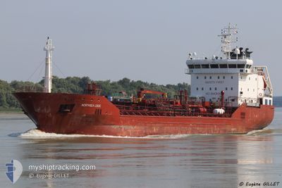
LARA S
Oil/Chemical Tanker
Current Trip
MDGIU
| Time Travelled | 6 days |
|---|---|
| Remaining Time | --- |
| Distance Travelled | 44.12 nm |
| Remaining Distance | --- |
| AVG Speed | 7.8 Knots |
| MAX Speed | 11.4 Knots |
| AVG Wind | 7.8 knots |
| MAX Wind | 14 knots |
| MIN Temp | 7.9°C / 46.22°F |
| MAX Temp | 29.9°C / 85.82°F |
| Draught | 6.3 m |
| Position Received | 15 d ago |
Current Position
| Longitude | 29.30407° |
|---|---|
| Latitude | 41.47800° |
| Status | Under way using engine |
| Speed | 10 Knots |
| Course | 8.6° |
| Area | Black Sea |
| Station | T-AIS |
| Position Received | 15 d ago |
Info
Information
The current position of LARA S is in Black Sea with coordinates 41.47800° / 29.30407° as reported on 2024-04-04 13:05 by AIS to our vessel tracker app. The vessel's current speed is 10 Knots
The vessel LARA S (IMO: 9334301, MMSI: 249689000) is a Oil/Chemical Tanker that was built in 2007 ( 17 years old ). It's sailing under the flag of [MT] Malta.
In this page you can find informations about the vessels current position, last detected port calls, and current voyage information. If the vessels is not in coverage by AIS you will find the latest position.
The current position of LARA S is detected by our AIS receivers and we are not responsible for the reliability of the data. The last position was recorded while the vessel was in Coverage by the Ais receivers of our vessel tracking app.
The current draught of LARA S as reported by AIS is 6.3 meters
Weather
| Temperature | 7.3°C / 45.14°F |
|---|---|
| Wind Speed | 5 knots |
| Direction | 103° ESE |
| Pressure | 1012.7 hPa |
| Humidity | 76.8 % |
| Cloud Coverage | 70 % |
Featured Company
Last Port Calls
| Port | Arrival | Departure | Time In Port |
|---|---|---|---|
| 2024-04-12 05:39 | 2024-04-13 05:02 | 23 h | |
| 2024-03-29 18:12 | 2024-03-31 09:13 | 1 d | |
| 2024-03-27 04:52 | |||
| 2024-03-20 16:08 | 2024-03-22 03:13 | 1 d | |
| 2024-03-18 05:01 | 2024-03-19 15:19 | 1 d | |
| 2024-02-25 13:57 | 2024-02-26 15:15 | 1 d | |
| 2024-02-16 12:54 | 2024-02-20 17:17 | 4 d | |
| 2024-02-09 17:13 | 2024-02-10 17:12 | 23 h | |
| 2024-02-06 05:35 | 2024-02-08 16:48 | 2 d | |
| 2024-02-03 19:47 | 2024-02-04 08:06 | 12 h |
Last Trips
| Origin | Departure | Destination | Arrival | Distance | |
|---|---|---|---|---|---|
| 2024-03-31 12:13 | 2024-04-12 08:39 | 796.65 nm | |||
| 2024-03-27 06:52 | 2024-03-29 20:12 | 586.30 nm | |||
| 2024-03-19 18:19 | 2024-03-20 19:08 | 144.19 nm | |||
| 2024-02-26 17:15 | 2024-03-18 08:01 | 1945.26 nm | |||
| 2024-02-20 19:17 | 2024-02-25 15:57 | 698.27 nm | |||
| 2024-02-10 20:12 | 2024-02-16 14:54 | 927.47 nm | |||
| 2024-02-08 19:48 | 2024-02-09 20:13 | 19.31 nm | |||
| 2024-02-04 11:06 | 2024-02-06 08:35 | 333.29 nm | |||
| 2024-01-30 03:40 | 2024-02-03 22:47 | 810.82 nm |
Events
| Time | Event | Details | Position / Dest | Info |
|---|---|---|---|---|
| 2024-04-17 12:12 | STOP Moving | 8.77 nm, North of TULCEA |
45.31797 / 28.86893
MDGIU
|
Speed: 0.2 kn Course: 268° |
| 2024-04-17 09:42 | START Moving | 4.14 nm, North West of TULCEA |
45.22473 / 28.72138
MDGIU
|
Speed: 7.8 kn Course: 78° |
| 2024-04-13 05:02 | PORT DEPARTURE |
|
45.46596 / 28.22530
MDGIU
|
Speed: 3.7 kn Course: 99° |
| 2024-04-13 04:58 | START Moving |
45.46720 / 28.21720
[MD] GIURGIULESTI
|
Speed: 3.7 kn Course: 99° |
|
| 2024-04-12 05:39 | STOP Moving |
45.46847 / 28.21195
[MD] GIURGIULESTI
|
Speed: Course: 278° |
|
| 2024-04-12 05:39 | PORT ARRIVAL |
|
45.46847 / 28.21195
[MD] GIURGIULESTI
|
Speed: 0.9 kn Course: 283° |
| 2024-04-12 04:58 | START Moving | 1.11 nm, North West of RENI |
45.45035 / 28.27010
MDGIU
|
Speed: 3.9 kn Course: 314° |
| 2024-04-10 18:03 | STOP Moving | 0.96 nm, North West of RENI |
45.44817 / 28.27187
MDGIU
|
Speed: 0.3 kn Course: 333° |
| 2024-04-10 05:22 | START Moving | 8.41 nm, North East of TULCEA |
45.30563 / 28.88748
MDGIU
|
Speed: 4.7 kn Course: 315° |