
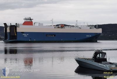
NORDIC RAY
Vehicles Carrier
Current Trip
| Time Travelled | 23 h, 15 mins |
|---|---|
| Remaining Time | 9 h, 33 mins |
| Distance Travelled | 426.51 nm |
| Remaining Distance | 180.11 nm |
| AVG Speed | 17.9 Knots |
| MAX Speed | 19.7 Knots |
| AVG Wind | 9.7 knots |
| MAX Wind | 17.8 knots |
| MIN Temp | 5.6°C / 42.08°F |
| MAX Temp | 8.4°C / 47.12°F |
| Draught | 7.6 m |
| Position Received | Now |
Current Position
| Longitude | 7.93182° |
|---|---|
| Latitude | 57.32753° |
| Status | Under way using engine |
| Speed | 18.8 Knots |
| Course | 30.6° |
| Area | North Sea |
| Station | T-AIS |
| Position Received | Now |
Info
Information
The current position of NORDIC RAY is in North Sea with coordinates 57.32753° / 7.93182° as reported on 2024-04-18 19:54 by AIS to our vessel tracker app. The vessel's current speed is 18.8 Knots and is heading at the port of DRAMMEN. The estimated time of arrival as calculated by MyShipTracking vessel tracking app is 2024-04-19 05:28 LT
The vessel NORDIC RAY (IMO: 9386225, MMSI: 309586000) is a Vehicles Carrier that was built in 2007 ( 17 years old ). It's sailing under the flag of [BS] Bahamas.
In this page you can find informations about the vessels current position, last detected port calls, and current voyage information. If the vessels is not in coverage by AIS you will find the latest position.
The current position of NORDIC RAY is detected by our AIS receivers and we are not responsible for the reliability of the data. The last position was recorded while the vessel was in Coverage by the Ais receivers of our vessel tracking app.
The current draught of NORDIC RAY as reported by AIS is 7.6 meters
Weather
| Temperature | 5.6°C / 42.08°F |
|---|---|
| Wind Speed | 6 knots |
| Direction | 174° S |
| Pressure | 1010.7 hPa |
| Humidity | 62.8 % |
| Cloud Coverage | 100 % |
Featured Company
Last Port Calls
| Port | Arrival | Departure | Time In Port |
|---|---|---|---|
| 2024-04-16 11:21 | 2024-04-17 20:40 | 1 d | |
| 2024-04-14 01:45 | 2024-04-14 13:34 | 11 h | |
| 2024-04-13 09:37 | 2024-04-13 14:22 | 4 h | |
| 2024-04-11 22:46 | 2024-04-12 14:01 | 15 h | |
| 2024-04-10 22:55 | 2024-04-11 14:16 | 15 h | |
| 2024-04-09 02:08 | 2024-04-10 03:56 | 1 d | |
| 2024-04-07 04:19 | 2024-04-07 14:14 | 9 h | |
| 2024-04-05 11:24 | 2024-04-06 10:15 | 22 h | |
| 2024-04-03 16:20 | 2024-04-04 12:43 | 20 h | |
| 2024-04-01 19:59 | 2024-04-02 16:13 | 20 h |
Last Trips
| Origin | Departure | Destination | Arrival | Distance | |
|---|---|---|---|---|---|
| 2024-04-14 15:34 | 2024-04-16 13:21 | 574.20 nm | |||
| 2024-04-13 16:22 | 2024-04-14 03:45 | 148.37 nm | |||
| 2024-04-12 16:01 | 2024-04-13 11:37 | 328.27 nm | |||
| 2024-04-11 16:16 | 2024-04-12 00:46 | 143.41 nm | |||
| 2024-04-10 05:56 | 2024-04-11 00:55 | 313.61 nm | |||
| 2024-04-07 16:14 | 2024-04-09 04:08 | 559.27 nm | |||
| 2024-04-06 12:15 | 2024-04-07 06:19 | 148.55 nm | |||
| 2024-04-04 14:43 | 2024-04-05 13:24 | 141.58 nm | |||
| 2024-04-02 18:13 | 2024-04-03 18:20 | 374.24 nm | |||
| 2024-04-01 02:30 | 2024-04-01 21:59 | 312.32 nm |
Events
| Time | Event | Details | Position / Dest | Info |
|---|---|---|---|---|
| 2024-04-18 16:58 | IN Coverage |
56.54732 / 7.09713
North Sea
NO DRM
|
Speed: 18.5 kn Course: 24.8° |
|
| 2024-04-18 13:36 | OUT of Coverage |
55.59407 / 6.32186
North Sea
NO DRM
|
Speed: 18.6 kn Course: 26.6° |
|
| 2024-04-18 13:01 | Detected in Sea | Danish part of the North Sea |
55.43452 / 6.18470
North Sea
NO DRM
|
Speed: 18.6 kn Course: 25.4° |
| 2024-04-18 10:14 | Change Sea Area | German part of the North Sea Dutch part of the North Sea |
54.65575 / 5.55905
North Sea
NO DRM
|
Speed: 18.4 kn Course: 29.4° |
| 2024-04-18 10:12 | IN Coverage |
54.65575 / 5.55905
North Sea
NO DRM
|
Speed: 18.4 kn Course: 29.4° |
|
| 2024-04-18 07:56 | Status Changed | Default Under way using engine |
54.01972 / 5.06722
NO DRM
|
Speed: 17.7 kn Course: 20.4° |
| 2024-04-18 06:58 | OUT of Coverage |
53.74115 / 4.90513
North Sea
NO DRM
|
Speed: 17.7 kn Course: 20.4° |
|
| 2024-04-18 03:00 | Status Changed | Under way using engine Default |
52.69624 / 4.00422
NO DRM
|
Speed: 18.4 kn Course: 43° |
| 2024-04-18 02:41 | Status Changed | Default Under way using engine |
52.62849 / 3.89975
NO DRM
|
Speed: 18.2 kn Course: 33° |
| 2024-04-18 02:32 | Status Changed | Under way using engine Default |
52.58986 / 3.85289
NO DRM
|
Speed: 18 kn Course: 40° |