
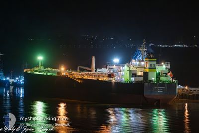
NIPPON PRINCESS
Crude Oil Tanker
Current Trip
| Time Travelled | 9 days |
|---|---|
| Remaining Time | --- |
| Distance Travelled | 2303.40 nm |
| Remaining Distance | --- |
| AVG Speed | 10.4 Knots |
| MAX Speed | 12.1 Knots |
| AVG Wind | 14.3 knots |
| MAX Wind | 23 knots |
| MIN Temp | -2.2°C / 28.04°F |
| MAX Temp | 12.4°C / 54.32°F |
| Draught | 13.8 m |
| Position Received | 2 h, 51 m ago |
Current Position
| Longitude | -2.27817° |
|---|---|
| Latitude | 49.94842° |
| Status | Under way using engine |
| Speed | 10.9 Knots |
| Course | 73° |
| Area | English Channel |
| Station | T-AIS |
| Position Received | 2 h, 51 m ago |
Info
Information
The current position of NIPPON PRINCESS is in English Channel with coordinates 49.94842° / -2.27817° as reported on 2024-04-19 08:43 by AIS to our vessel tracker app. The vessel's current speed is 10.9 Knots and is heading at the port of FAWLEY. The estimated time of arrival as calculated by MyShipTracking vessel tracking app is 2024-04-19 17:00 LT
The vessel NIPPON PRINCESS (IMO: 9380673, MMSI: 538005955) is a Crude Oil Tanker that was built in 2008 ( 16 years old ). It's sailing under the flag of [MH] Marshall Is.
In this page you can find informations about the vessels current position, last detected port calls, and current voyage information. If the vessels is not in coverage by AIS you will find the latest position.
The current position of NIPPON PRINCESS is detected by our AIS receivers and we are not responsible for the reliability of the data. The last position was recorded while the vessel was in Coverage by the Ais receivers of our vessel tracking app.
The current draught of NIPPON PRINCESS as reported by AIS is 13.8 meters
Weather
| Temperature | 10.6°C / 51.08°F |
|---|---|
| Wind Speed | 17 knots |
| Direction | 296° WNW |
| Pressure | 1020.2 hPa |
| Humidity | 88.4 % |
| Cloud Coverage | 64 % |
Featured Company
Last Port Calls
| Port | Arrival | Departure | Time In Port |
|---|---|---|---|
| 2024-04-09 04:19 | 2024-04-10 06:19 | 1 d | |
| 2024-03-23 22:32 | 2024-03-25 15:25 | 1 d | |
| 2024-03-10 19:29 | 2024-03-12 11:15 | 1 d | |
| 2024-02-28 11:32 |
Most Visited Ports (Last year)
| Port | Arrivals | |
|---|---|---|
| 5 | ||
| 4 | ||
| 2 | ||
| 2 | ||
| 2 | ||
| 1 |
Last Trips
| Origin | Departure | Destination | Arrival | Distance | |
|---|---|---|---|---|---|
| 2024-03-25 15:25 | 2024-04-09 01:49 | 2608.12 nm | |||
| 2024-03-12 08:45 | 2024-03-23 22:32 | 2367.26 nm | |||
| 2024-02-28 11:32 | 2024-03-10 16:59 | 2623.14 nm |
Events
| Time | Event | Details | Position / Dest | Info |
|---|---|---|---|---|
| 2024-04-19 09:06 | Status Changed | Default Under way using engine |
49.96787 / -2.17752
CAWHH>>GBFAW
|
Speed: 10.9 kn Course: 73° |
| 2024-04-19 08:43 | OUT of Coverage |
49.94842 / -2.27817
English Channel
CAWHH>>GBFAW
|
Speed: 10.9 kn Course: 73° |
|
| 2024-04-19 08:05 | ETA Changed | 2024/04/19 17:00 2024/04/19 17:30 |
49.91112 / -2.45223
CAWHH>>GBFAW
|
Speed: 11.4 kn Course: 67° |
| 2024-04-19 06:36 | Detected in Sea | Guernsey part of the English Channel |
49.81838 / -2.87137
English Channel
CAWHH>>GBFAW
|
Speed: 11.9 kn Course: 78° |
| 2024-04-19 06:36 | Status Changed | Under way using engine Default |
49.81838 / -2.87137
CAWHH>>GBFAW
|
Speed: 12 kn Course: 77° |
| 2024-04-19 06:36 | IN Coverage |
49.81838 / -2.87137
English Channel
CAWHH>>GBFAW
|
Speed: 11.9 kn Course: 78° |
|
| 2024-04-19 05:00 | OUT of Coverage |
49.75455 / -3.35590
English Channel
CAWHH>>GBFAW
|
Speed: 11.9 kn Course: 78° |
|
| 2024-04-18 22:17 | Change Sea Area | United Kingdom part of the English Channel United Kingdom part of the Celtic Sea |
49.67798 / -5.38438
English Channel
CAWHH>>GBFAW
|
Speed: 11.3 kn Course: 87° |
| 2024-04-18 21:14 | Status Changed | Under way using engine Default |
49.65547 / -5.68598
CAWHH>>GBFAW
|
Speed: 11.1 kn Course: 85° |
| 2024-04-18 20:45 | Status Changed | Default Under way using engine |
49.64722 / -5.82453
CAWHH>>GBFAW
|
Speed: 11.1 kn Course: 84° |