
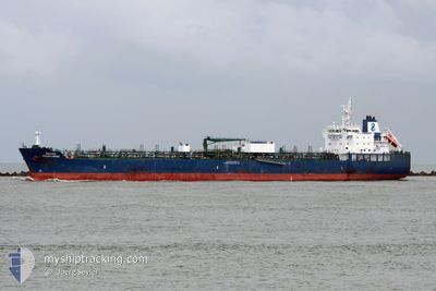
HAFNIA AVENTURINE
Tanker
Current Trip
BR SUA
| Time Travelled | 12 days |
|---|---|
| Remaining Time | --- |
| Distance Travelled | 4088.96 nm |
| Remaining Distance | --- |
| AVG Speed | 13.2 Knots |
| MAX Speed | 16.3 Knots |
| AVG Wind | 12 knots |
| MAX Wind | 19.5 knots |
| MIN Temp | 23.4°C / 74.12°F |
| MAX Temp | 30.7°C / 87.26°F |
| Draught | 10.6 m |
| Position Received | 2 d ago |
Current Position
| Longitude | -82.07121° |
|---|---|
| Latitude | 20.20781° |
| Status | Under way using engine |
| Speed | 12.6 Knots |
| Course | 295.3° |
| Area | Caribbean Sea |
| Station | T-AIS |
| Position Received | 2 d ago |
Info
Information
The current position of HAFNIA AVENTURINE is in Caribbean Sea with coordinates 20.20781° / -82.07121° as reported on 2024-04-22 10:05 by AIS to our vessel tracker app. The vessel's current speed is 12.6 Knots
The vessel HAFNIA AVENTURINE (IMO: 9711547, MMSI: 538005774) is a Tanker It's sailing under the flag of [MH] Marshall Is.
In this page you can find informations about the vessels current position, last detected port calls, and current voyage information. If the vessels is not in coverage by AIS you will find the latest position.
The current position of HAFNIA AVENTURINE is detected by our AIS receivers and we are not responsible for the reliability of the data. The last position was recorded while the vessel was in Coverage by the Ais receivers of our vessel tracking app.
The current draught of HAFNIA AVENTURINE as reported by AIS is 10.6 meters
Weather
| Temperature | 23°C / 73.4°F |
|---|---|
| Wind Speed | 8 knots |
| Direction | 73° ENE |
| Pressure | 1017.8 hPa |
| Humidity | 78.1 % |
| Cloud Coverage | --- |
Featured Company
Last Port Calls
| Port | Arrival | Departure | Time In Port |
|---|---|---|---|
| 2024-04-09 21:20 | 2024-04-11 13:43 | 1 d | |
| 2024-03-30 00:51 | 2024-03-30 13:27 | 12 h | |
| 2024-02-22 02:51 | 2024-02-22 23:11 | 20 h | |
| 2024-02-13 11:39 | 2024-02-16 01:05 | 2 d |
Most Visited Ports (Last year)
| Port | Arrivals | |
|---|---|---|
| 4 | ||
| 2 | ||
| 2 | ||
| 1 | ||
| 1 | ||
| 1 |
Last Trips
| Origin | Departure | Destination | Arrival | Distance | |
|---|---|---|---|---|---|
| 2024-03-30 15:27 | 2024-04-09 18:20 | 3352.72 nm | |||
| 2024-02-23 04:41 | 2024-03-30 02:51 | 9605.86 nm | |||
| 2024-02-16 06:35 | 2024-02-22 08:21 | 465.85 nm | |||
| 2024-01-15 03:59 | 2024-02-13 17:09 | 8355.71 nm |
Events
| Time | Event | Details | Position / Dest | Info |
|---|---|---|---|---|
| 2024-04-22 10:12 | Status Changed | Default Under way using engine |
20.21765 / -82.09315
BR SUA
|
Speed: 12.6 kn Course: 295.3° |
| 2024-04-22 10:05 | OUT of Coverage |
20.20781 / -82.07121
Caribbean Sea
|
Speed: 12.6 kn Course: 295.3° |
|
| 2024-04-22 09:51 | Status Changed | Under way using engine Default |
20.18589 / -82.02166
BR SUA
|
Speed: 12.6 kn Course: 294° |
| 2024-04-22 09:11 | Status Changed | Default Under way using engine |
20.12889 / -81.88847
BR SUA
|
Speed: 12.2 kn Course: 294.3° |
| 2024-04-22 08:22 | Status Changed | Under way using engine Default |
20.05919 / -81.72489
BR SUA
|
Speed: 12.4 kn Course: 294° |
| 2024-04-22 08:07 | Status Changed | Default Under way using engine |
20.03749 / -81.67442
BR SUA
|
Speed: 12.4 kn Course: 294° |
| 2024-04-22 07:56 | Change Sea Area | Cayman Islands part of the Caribbean Sea Grenadian part of the Caribbean Sea |
20.02148 / -81.63706
Caribbean Sea
|
Speed: 12.3 kn Course: 294.3° |
| 2024-04-22 07:56 | Status Changed | Under way using engine Default |
20.02148 / -81.63706
BR SUA
|
Speed: 12.5 kn Course: 295° |
| 2024-04-22 07:38 | IN Coverage |
20.02148 / -81.63706
Caribbean Sea
|
Speed: 12.3 kn Course: 294.3° |
|
| 2024-04-18 07:17 | OUT of Coverage |
11.64797 / -61.63439
Caribbean Sea
|
Speed: 12.9 kn Course: 273.9° |