
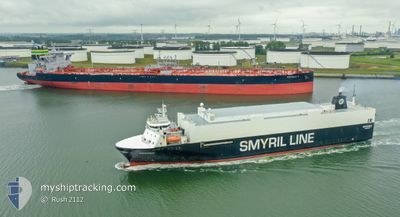
MYKINES
Vehicles Carrier
Current Trip
| Trip Time | 1 day |
|---|---|
| Trip Distance | 719.26 nm |
| AVG Speed | 14.8 Knots |
| MAX Speed | 19.4 Knots |
| Draught | 6.3 m |
| AVG Wind | 15.2 knots |
| MAX Wind | 23 knots |
| MIN Temp | 3.9°C / 39.02°F |
| MAX Temp | 7.8°C / 46.04°F |
| Position Received | Now |
Current Position
| Longitude | -6.76776° |
|---|---|
| Latitude | 62.00028° |
| Status | Under way using engine |
| Speed | 5.4 Knots |
| Course | 333° |
| Area | North Atlantic Ocean |
| Station | T-AIS |
| Position Received | Now |
Info
Information
The current position of MYKINES is in North Atlantic Ocean with coordinates 62.00028° / -6.76776° as reported on 2024-04-24 22:00 by AIS to our vessel tracker app. The vessel's current speed is 5.4 Knots and is currently inside the port of TORSHAVN.
The vessel MYKINES (IMO: 9121998, MMSI: 231002000) is a Vehicles Carrier that was built in 1996 ( 28 years old ). It's sailing under the flag of [FO] Faroe Is.
In this page you can find informations about the vessels current position, last detected port calls, and current voyage information. If the vessels is not in coverage by AIS you will find the latest position.
The current position of MYKINES is detected by our AIS receivers and we are not responsible for the reliability of the data. The last position was recorded while the vessel was in Coverage by the Ais receivers of our vessel tracking app.
The current draught of MYKINES as reported by AIS is 6.3 meters
Weather
| Temperature | 3.8°C / 38.84°F |
|---|---|
| Wind Speed | 15 knots |
| Direction | 21° NNE |
| Pressure | 1015.1 hPa |
| Humidity | 71.4 % |
| Cloud Coverage | 34 % |
Featured Company
Last Port Calls
| Port | Arrival | Departure | Time In Port |
|---|---|---|---|
| 2024-04-24 21:58 | |||
| 2024-04-22 16:47 | 2024-04-22 23:53 | 7 h | |
| 2024-04-19 07:47 | 2024-04-19 21:10 | 13 h | |
| 2024-04-17 21:56 | 2024-04-18 01:16 | 3 h | |
| 2024-04-15 16:29 | 2024-04-15 23:58 | 7 h | |
| 2024-04-15 15:41 | 2024-04-15 16:27 | 46 m | |
| 2024-04-12 07:37 | 2024-04-12 21:25 | 13 h | |
| 2024-04-10 19:32 | 2024-04-11 03:17 | 7 h | |
| 2024-04-08 16:41 | |||
| 2024-04-08 15:49 | 2024-04-08 16:32 | 43 m |
Last Trips
| Origin | Departure | Destination | Arrival | Distance | |
|---|---|---|---|---|---|
| 2024-04-23 01:53 | 2024-04-24 22:58 | 719.26 nm | |||
| 2024-04-19 21:10 | 2024-04-22 18:47 | 1103.57 nm | |||
| 2024-04-18 02:16 | 2024-04-19 07:47 | 428.52 nm | |||
| 2024-04-16 01:58 | 2024-04-17 22:56 | 719.59 nm | |||
| 2024-04-15 18:27 | 2024-04-15 18:29 | 0.24 nm | |||
| 2024-04-12 21:25 | 2024-04-15 17:41 | 1098.15 nm | |||
| 2024-04-11 04:17 | 2024-04-12 07:37 | 429.10 nm | |||
| 2024-04-08 18:32 | 2024-04-10 20:32 | 720.24 nm | |||
| 2024-04-08 18:32 | 2024-04-08 18:41 | 0.37 nm | |||
| 2024-04-05 15:52 | 2024-04-08 17:49 | 1198.63 nm |
Events
| Time | Event | Details | Position / Dest | Info |
|---|---|---|---|---|
| 2024-04-24 21:58 | PORT ARRIVAL |
|
61.99810 / -6.76513
[FO] TORSHAVN
|
Speed: 4.8 kn Course: 324° |
| 2024-04-24 21:20 | Change Sea Area | Faeroe Islands part of the North Atlantic Ocean United Kingdom part of the North Atlantic Ocean |
61.88401 / -6.56869
North Atlantic Ocean
FOTHO
|
Speed: 15.4 kn Course: 328.7° |
| 2024-04-24 21:17 | Status Changed | Under way using engine Default |
61.87454 / -6.55641
FOTHO
|
Speed: 16 kn Course: 328° |
| 2024-04-24 21:04 | IN Coverage |
61.88401 / -6.56869
North Atlantic Ocean
FOTHO
|
Speed: 15.4 kn Course: 328.7° |
|
| 2024-04-24 10:14 | Status Changed | Default Under way using engine |
59.23868 / -3.88330
FOTHO
|
Speed: 16.2 kn Course: 332.9° |
| 2024-04-24 10:06 | OUT of Coverage |
59.20618 / -3.85068
North Atlantic Ocean
FOTHO
|
Speed: 16.2 kn Course: 332.9° |
|
| 2024-04-24 08:23 | Change Sea Area | United Kingdom part of the North Atlantic Ocean United Kingdom part of the North Sea |
58.78560 / -3.43030
North Atlantic Ocean
FOTHO
|
Speed: 15.3 kn Course: 301.5° |
| 2024-04-24 05:58 | Status Changed | Under way using engine Default |
58.44095 / -2.69411
FOTHO
|
Speed: 15.9 kn Course: 327° |
| 2024-04-24 05:50 | IN Coverage |
58.44095 / -2.69411
North Sea
FOTHO
|
Speed: 15.9 kn Course: 326.4° |
|
| 2024-04-24 03:46 | OUT of Coverage |
57.92927 / -2.06359
North Sea
FOTHO
|
Speed: 16.9 kn Course: 326.6° |