
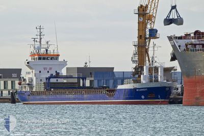
MY ARMONY
General Cargo
Current Trip
| Time Travelled | 6 days |
|---|---|
| Remaining Time | 2 days |
| Distance Travelled | 1523.99 nm |
| Remaining Distance | 629.11 nm |
| AVG Speed | 9.7 Knots |
| MAX Speed | 11.7 Knots |
| AVG Wind | 12.2 knots |
| MAX Wind | 24.8 knots |
| MIN Temp | 9.8°C / 49.64°F |
| MAX Temp | 17.7°C / 63.86°F |
| Draught | 5.8 m |
| Position Received | 8 h, 23 m ago |
Current Position
| Longitude | 15.20552° |
|---|---|
| Latitude | 36.58667° |
| Status | Under way using engine |
| Speed | 10.5 Knots |
| Course | 90.4° |
| Area | Mediterranean Sea - Eastern Basin |
| Station | T-AIS |
| Position Received | 8 h, 23 m ago |
Info
Information
The current position of MY ARMONY is in Mediterranean Sea - Eastern Basin with coordinates 36.58667° / 15.20552° as reported on 2024-04-25 06:01 by AIS to our vessel tracker app. The vessel's current speed is 10.5 Knots and is heading at the port of IZMIR. The estimated time of arrival as calculated by MyShipTracking vessel tracking app is 2024-04-27 18:35 LT
The vessel MY ARMONY (IMO: 9190365, MMSI: 314490000) is a General Cargo that was built in 1999 ( 25 years old ). It's sailing under the flag of [BB] Barbados.
In this page you can find informations about the vessels current position, last detected port calls, and current voyage information. If the vessels is not in coverage by AIS you will find the latest position.
The current position of MY ARMONY is detected by our AIS receivers and we are not responsible for the reliability of the data. The last position was recorded while the vessel was in Coverage by the Ais receivers of our vessel tracking app.
The current draught of MY ARMONY as reported by AIS is 5.8 meters
Weather
| Temperature | 14.6°C / 58.28°F |
|---|---|
| Wind Speed | 16 knots |
| Direction | 279° W |
| Pressure | 1012.5 hPa |
| Humidity | 60.1 % |
| Cloud Coverage | --- |
Featured Company
Last Port Calls
| Port | Arrival | Departure | Time In Port |
|---|---|---|---|
| 2024-04-16 14:06 | 2024-04-18 19:55 | 2 d | |
| 2024-04-11 13:55 | 2024-04-13 09:25 | 1 d | |
| 2024-04-01 05:34 | 2024-04-03 10:23 | 2 d | |
| 2024-03-28 22:10 | 2024-03-30 02:54 | 1 d | |
| 2024-03-15 16:55 | 2024-03-15 20:07 | 3 h | |
| 2024-03-15 08:00 | 2024-03-15 14:50 | 6 h | |
| 2024-03-03 13:39 | 2024-03-04 18:21 | 1 d | |
| 2024-02-24 05:53 | 2024-02-26 19:16 | 2 d | |
| 2024-02-10 18:12 | 2024-02-15 22:01 | 5 d |
Last Trips
| Origin | Departure | Destination | Arrival | Distance | |
|---|---|---|---|---|---|
| 2024-04-13 11:25 | 2024-04-16 15:06 | 617.13 nm | |||
| 2024-04-03 13:23 | 2024-04-11 15:55 | 1451.57 nm | |||
| 2024-03-30 05:54 | 2024-04-01 08:34 | 398.05 nm | |||
| 2024-03-15 21:07 | 2024-03-29 01:10 | 1874.75 nm | |||
| 2024-03-15 14:50 | 2024-03-15 17:55 | 13.20 nm | |||
| 2024-03-04 19:21 | 2024-03-15 08:00 | 1519.18 nm | |||
| 2024-02-26 19:16 | 2024-03-03 14:39 | 729.21 nm | |||
| 2024-02-15 23:01 | 2024-02-24 05:53 | 512.38 nm | |||
| 2024-01-29 15:19 | 2024-02-10 19:12 | 2485.25 nm |
Events
| Time | Event | Details | Position / Dest | Info |
|---|---|---|---|---|
| 2024-04-25 06:25 | Status Changed | Default Under way using engine |
36.58627 / 15.29503
IZMIR
|
Speed: 10.5 kn Course: 90.4° |
| 2024-04-25 06:01 | OUT of Coverage |
36.58667 / 15.20552
Mediterranean Sea - Eastern Basin
IZMIR
|
Speed: 10.5 kn Course: 90.4° |
|
| 2024-04-25 05:48 | Status Changed | Under way using engine Default |
36.58684 / 15.15840
IZMIR
|
Speed: 10.3 kn Course: 100° |
| 2024-04-25 05:48 | IN Coverage |
36.58677 / 15.16561
Mediterranean Sea - Eastern Basin
IZMIR
|
Speed: 10.4 kn Course: 89.5° |
|
| 2024-04-25 04:41 | Status Changed | Default Under way using engine |
36.60580 / 14.91963
IZMIR
|
Speed: 10.5 kn Course: 100.1° |
| 2024-04-25 04:38 | OUT of Coverage |
36.60765 / 14.90718
Mediterranean Sea - Eastern Basin
IZMIR
|
Speed: 10.5 kn Course: 100.1° |
|
| 2024-04-24 22:37 | Status Changed | Under way using engine Default |
36.99909 / 13.68129
IZMIR
|
Speed: 10.4 kn Course: 113° |
| 2024-04-24 22:30 | IN Coverage |
36.99909 / 13.68129
Mediterranean Sea - Eastern Basin
IZMIR
|
Speed: 10.3 kn Course: 113.9° |
|
| 2024-04-24 15:09 | OUT of Coverage |
37.52355 / 12.19772
Mediterranean Sea - Eastern Basin
IZMIR
|
Speed: 10.2 kn Course: 112.9° |
|
| 2024-04-24 14:13 | Change Sea Area | Italian part of the Mediterranean Sea - Eastern Basin Italian part of the Mediterranean Sea - Western Basin |
37.58359 / 12.00904
Mediterranean Sea - Eastern Basin
IZMIR
|
Speed: 10.5 kn Course: 112.6° |