
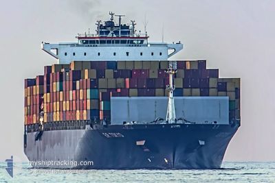
MSC TOKYO
Container Ship
Current Trip
| Time Travelled | 22 h, 48 mins |
|---|---|
| Remaining Time | --- |
| Distance Travelled | 368.89 nm |
| Remaining Distance | 1548.22 nm |
| AVG Speed | 16.3 Knots |
| MAX Speed | 19.8 Knots |
| AVG Wind | 5 knots |
| MAX Wind | 7.3 knots |
| MIN Temp | 28.7°C / 83.66°F |
| MAX Temp | 30.2°C / 86.36°F |
| Draught | 14.8 m |
| Position Received | 12 d ago |
Current Position
| Longitude | 54.79013° |
|---|---|
| Latitude | 25.28015° |
| Status | Under way using engine |
| Speed | 11.6 Knots |
| Course | 344.1° |
| Area | Persian Gulf |
| Station | T-AIS |
| Position Received | 12 d ago |
Info
Information
The current position of MSC TOKYO is in Persian Gulf with coordinates 25.28015° / 54.79013° as reported on 2024-04-11 16:55 by AIS to our vessel tracker app. The vessel's current speed is 11.6 Knots and is heading at the port of MUNDRA.
The vessel MSC TOKYO (IMO: 9318046, MMSI: 636020497) is a Container Ship that was built in 2006 ( 18 years old ). It's sailing under the flag of [LR] Liberia.
In this page you can find informations about the vessels current position, last detected port calls, and current voyage information. If the vessels is not in coverage by AIS you will find the latest position.
The current position of MSC TOKYO is detected by our AIS receivers and we are not responsible for the reliability of the data. The last position was recorded while the vessel was in Coverage by the Ais receivers of our vessel tracking app.
The current draught of MSC TOKYO as reported by AIS is 14.8 meters
Weather
| Temperature | 29.9°C / 85.82°F |
|---|---|
| Wind Speed | 4 knots |
| Direction | 18° NNE |
| Pressure | 1007.8 hPa |
| Humidity | 68.9 % |
| Cloud Coverage | 81 % |
Featured Company
Last Port Calls
| Port | Arrival | Departure | Time In Port |
|---|---|---|---|
| 2024-04-22 20:28 | 2024-04-23 15:56 | 19 h | |
| 2024-04-14 09:14 | 2024-04-16 06:30 | 1 d | |
| 2024-04-08 08:33 | 2024-04-11 15:20 | 3 d | |
| 2024-04-02 20:26 | 2024-04-04 12:58 | 1 d | |
| 2024-03-19 17:19 | 2024-03-23 01:50 | 3 d | |
| 2024-02-27 05:28 | 2024-02-28 03:24 | 21 h | |
| 2024-02-20 14:09 | 2024-02-22 14:09 | 2 d | |
| 2024-02-13 17:15 | 2024-02-14 14:49 | 21 h | |
| 2024-02-10 10:35 | 2024-02-10 23:05 | 12 h | |
| 2024-02-08 08:44 | 2024-02-09 09:59 | 1 d |
Most Visited Ports (Last year)
| Port | Arrivals | |
|---|---|---|
| 8 | ||
| 6 | ||
| 4 | ||
| 4 | ||
| 4 | ||
| 4 |
Last Trips
| Origin | Departure | Destination | Arrival | Distance | |
|---|---|---|---|---|---|
| 2024-04-16 12:00 | 2024-04-23 01:58 | 1221.52 nm | |||
| 2024-04-11 19:20 | 2024-04-14 14:44 | 918.69 nm | |||
| 2024-04-04 16:58 | 2024-04-08 12:33 | 55.04 nm | |||
| 2024-03-23 03:50 | 2024-04-03 00:26 | 4232.12 nm | |||
| 2024-02-27 22:24 | 2024-03-19 19:19 | 7166.57 nm | |||
| 2024-02-22 08:09 | 2024-02-27 00:28 | 1154.85 nm | |||
| 2024-02-14 09:49 | 2024-02-20 08:09 | 1137.99 nm | |||
| 2024-02-10 18:05 | 2024-02-13 12:15 | 477.73 nm | |||
| 2024-02-09 04:59 | 2024-02-10 05:35 | 142.47 nm | |||
| 2024-02-05 19:16 | 2024-02-08 03:44 | 729.58 nm |
Events
| Time | Event | Details | Position / Dest | Info |
|---|---|---|---|---|
| 2024-04-23 15:56 | PORT DEPARTURE |
|
6.97520 / 79.83260
INMUN
|
Speed: 7.8 kn Course: 357° |
| 2024-04-23 15:44 | START Moving |
6.95219 / 79.83414
[LK] COLOMBO
|
Speed: 4.1 kn Course: 3° |
|
| 2024-04-22 20:56 | STOP Moving |
6.94606 / 79.83740
[LK] COLOMBO
|
Speed: 0.1 kn Course: 270° |
|
| 2024-04-22 20:28 | PORT ARRIVAL |
|
6.95363 / 79.83549
[LK] COLOMBO
|
Speed: 5.7 kn Course: 174° |
| 2024-04-22 17:08 | START Moving | 11.97 nm, West of COLOMBO |
6.98343 / 79.63808
INMUN
|
Speed: 3.1 kn Course: 355° |
| 2024-04-20 11:48 | STOP Moving | 11.75 nm, West of COLOMBO |
6.98167 / 79.64167
INMUN
|
Speed: Course: -1° |
| 2024-04-20 10:52 | START Moving | 14.88 nm, West of COLOMBO |
7.03368 / 79.59987
INMUN
|
Speed: 7.3 kn Course: 142° |
| 2024-04-20 05:36 | STOP Moving | 20.86 nm, West of COLOMBO |
7.04333 / 79.49834
INMUN
|
Speed: Course: -1° |
| 2024-04-16 06:30 | PORT DEPARTURE |
|
22.72167 / 69.69167
INMUN
|
Speed: 5.5 kn Course: 170° |
| 2024-04-16 06:26 | START Moving |
22.73004 / 69.69270
[IN] MUNDRA
|
Speed: 5.5 kn Course: 170° |