
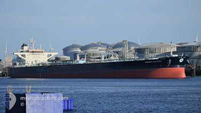
MINERVA KALYPSO
Tanker
Current Trip
| Time Travelled | 8 days |
|---|---|
| Remaining Time | --- |
| Distance Travelled | 1061.09 nm |
| Remaining Distance | --- |
| AVG Speed | 10.1 Knots |
| MAX Speed | 13.5 Knots |
| AVG Wind | 11 knots |
| MAX Wind | 33.5 knots |
| MIN Temp | 10.1°C / 50.18°F |
| MAX Temp | 24.4°C / 75.92°F |
| Draught | 12.7 m |
| Position Received | 1 h, 31 m ago |
Current Position
| Longitude | 27.08817° |
|---|---|
| Latitude | 40.54194° |
| Status | Under way using engine |
| Speed | 10.6 Knots |
| Course | 269.6° |
| Area | Sea of Marmara |
| Station | T-AIS |
| Position Received | 1 h, 31 m ago |
Info
Information
The current position of MINERVA KALYPSO is in Sea of Marmara with coordinates 40.54194° / 27.08817° as reported on 2024-04-24 23:32 by AIS to our vessel tracker app. The vessel's current speed is 10.6 Knots and is heading at the port of PACHI. The estimated time of arrival as calculated by MyShipTracking vessel tracking app is 2024-04-26 05:00 LT
The vessel MINERVA KALYPSO (IMO: 9785225, MMSI: 241502000) is a Tanker It's sailing under the flag of [GR] Greece.
In this page you can find informations about the vessels current position, last detected port calls, and current voyage information. If the vessels is not in coverage by AIS you will find the latest position.
The current position of MINERVA KALYPSO is detected by our AIS receivers and we are not responsible for the reliability of the data. The last position was recorded while the vessel was in Coverage by the Ais receivers of our vessel tracking app.
The current draught of MINERVA KALYPSO as reported by AIS is 12.7 meters
Weather
| Temperature | 16.1°C / 60.98°F |
|---|---|
| Wind Speed | 3 knots |
| Direction | 275° W |
| Pressure | 1004.7 hPa |
| Humidity | 85.4 % |
| Cloud Coverage | 100 % |
Featured Company
Last Port Calls
Most Visited Ports (Last year)
| Port | Arrivals | |
|---|---|---|
| 3 | ||
| 2 | ||
| 2 | ||
| 2 | ||
| 1 | ||
| 1 |
Last Trips
| Origin | Departure | Destination | Arrival | Distance | |
|---|---|---|---|---|---|
| 2024-04-02 08:19 | 2024-04-16 10:30 | 2703.30 nm | |||
| 2024-03-28 12:04 | 2024-04-01 07:19 | 1078.17 nm | |||
| 2024-02-29 18:52 | 2024-03-26 21:24 | 2101.31 nm | |||
| 2024-02-24 04:21 | 2024-02-29 16:57 | 1212.81 nm | |||
| 2023-12-10 01:09 | 2024-02-22 10:03 | 10313.69 nm |
Events
| Time | Event | Details | Position / Dest | Info |
|---|---|---|---|---|
| 2024-04-24 23:32 | Status Changed | Default Under way using engine |
40.54188 / 27.08689
PACHI GREECE
|
Speed: 10.6 kn Course: 269.6° |
| 2024-04-24 23:32 | Status Changed | Under way using engine Default |
40.54194 / 27.08817
PACHI GREECE
|
Speed: 7.7 kn Course: 307° |
| 2024-04-24 23:32 | OUT of Coverage |
40.54194 / 27.08817
Sea of Marmara
PACHI GREECE
|
Speed: 10.6 kn Course: 269.6° |
|
| 2024-04-24 23:10 | Status Changed | Default Under way using engine |
40.52175 / 27.16249
PACHI GREECE
|
Speed: 5.8 kn Course: 328.4° |
| 2024-04-24 23:05 | START Moving | 3.81 nm, North of ICDAS |
40.51335 / 27.17040
PACHI GREECE
|
Speed: 5.8 kn Course: 328.4° |
| 2024-04-24 22:52 | Status Changed | Under way using engine At anchor |
40.50285 / 27.17581
PACHI GREECE
|
Speed: Course: 306° |
| 2024-04-24 20:59 | Status Changed | At anchor Default |
40.50163 / 27.17920
PACHI GREECE
|
Speed: Course: -1° |
| 2024-04-24 20:47 | Status Changed | Default At anchor |
40.50167 / 27.17833
PACHI GREECE
|
Speed: Course: 266° |
| 2024-04-24 20:41 | Status Changed | At anchor Default |
40.50175 / 27.17914
PACHI GREECE
|
Speed: Course: -1° |
| 2024-04-24 19:59 | Status Changed | Default At anchor |
40.50167 / 27.17833
PACHI GREECE
|
Speed: Course: 267° |