
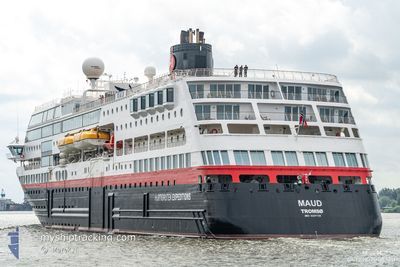
MAUD
Ro-Ro/Passenger Ship
Current Trip
GB DVN
| Time Travelled | 12 h, 27 mins |
|---|---|
| Remaining Time | --- |
| Distance Travelled | 164.27 nm |
| Remaining Distance | --- |
| AVG Speed | 13.6 Knots |
| MAX Speed | 15.8 Knots |
| AVG Wind | 10.1 knots |
| MAX Wind | 15 knots |
| MIN Temp | 7°C / 44.6°F |
| MAX Temp | 8.8°C / 47.84°F |
| Draught | 5 m |
| Position Received | 5 h, 32 m ago |
Current Position
| Longitude | -6.90763° |
|---|---|
| Latitude | 55.85317° |
| Status | Under way using engine |
| Speed | 14.8 Knots |
| Course | 330.2° |
| Area | Inner Seas off the West Coast of Scotland |
| Station | T-AIS |
| Position Received | 5 h, 32 m ago |
Info
Information
The current position of MAUD is in Inner Seas off the West Coast of Scotland with coordinates 55.85317° / -6.90763° as reported on 2024-04-17 23:59 by AIS to our vessel tracker app. The vessel's current speed is 14.8 Knots
The vessel MAUD (IMO: 9247728, MMSI: 258595000) is a Ro-Ro/Passenger Ship that was built in 2003 ( 21 years old ). It's sailing under the flag of [NO] Norway.
In this page you can find informations about the vessels current position, last detected port calls, and current voyage information. If the vessels is not in coverage by AIS you will find the latest position.
The current position of MAUD is detected by our AIS receivers and we are not responsible for the reliability of the data. The last position was recorded while the vessel was in Coverage by the Ais receivers of our vessel tracking app.
The current draught of MAUD as reported by AIS is 5 meters
Weather
| Temperature | 8.6°C / 47.48°F |
|---|---|
| Wind Speed | 14 knots |
| Direction | 260° W |
| Pressure | 1018.6 hPa |
| Humidity | 88.7 % |
| Cloud Coverage | 100 % |
Featured Company
Last Port Calls
| Port | Arrival | Departure | Time In Port |
|---|---|---|---|
| 2024-04-17 06:04 | 2024-04-17 17:04 | 10 h | |
| 2024-04-14 06:15 | 2024-04-14 17:04 | 10 h | |
| 2024-04-12 04:12 |
Last Trips
| Origin | Departure | Destination | Arrival | Distance | |
|---|---|---|---|---|---|
| 2024-04-14 18:04 | 2024-04-17 07:04 | 611.98 nm | |||
| 2024-04-12 06:12 | 2024-04-14 07:15 | 463.44 nm |
Events
| Time | Event | Details | Position / Dest | Info |
|---|---|---|---|---|
| 2024-04-18 00:13 | Status Changed | Default Under way using engine |
55.90500 / -6.95667
GB DVN
|
Speed: 14.8 kn Course: 330.2° |
| 2024-04-17 23:59 | OUT of Coverage |
55.85317 / -6.90763
Inner Seas off the West Coast of Scotland
GB DVN
|
Speed: 14.8 kn Course: 330.2° |
|
| 2024-04-17 19:55 | Destination Changed | GB DVN GB BEL |
55.15450 / -5.79739
GB DVN
|
Speed: 13.8 kn Course: 341.2° |
| 2024-04-17 19:55 | ETA Changed | 2024/04/18 11:00 2024/04/17 07:00 |
55.15450 / -5.79739
GB DVN
|
Speed: 13.8 kn Course: 341.2° |
| 2024-04-17 19:39 | Status Changed | Under way using engine Default |
55.09997 / -5.76527
GB BEL
|
Speed: 13.7 kn Course: 343° |
| 2024-04-17 19:39 | IN Coverage |
55.10409 / -5.76743
Inner Seas off the West Coast of Scotland
|
Speed: 13.5 kn Course: 343.1° |
|
| 2024-04-17 18:23 | Status Changed | Default Under way using engine |
54.83750 / -5.66061
GB BEL
|
Speed: 12.2 kn Course: 351.7° |
| 2024-04-17 18:18 | OUT of Coverage |
54.82112 / -5.65704
Inner Seas off the West Coast of Scotland
|
Speed: 12.2 kn Course: 351.7° |
|
| 2024-04-17 18:15 | Status Changed | Under way using engine Default |
54.81050 / -5.65457
GB BEL
|
Speed: 12.4 kn Course: 352° |
| 2024-04-17 17:55 | Status Changed | Default Under way using engine |
54.74343 / -5.64918
GB BEL
|
Speed: 12.8 kn Course: 30.3° |