
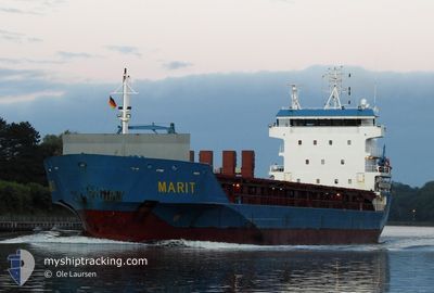
MARIT
General Cargo
Current Trip
| Time Travelled | 2 days |
|---|---|
| Remaining Time | --- |
| Distance Travelled | 492.57 nm |
| Remaining Distance | --- |
| AVG Speed | 10.2 Knots |
| MAX Speed | 11.7 Knots |
| AVG Wind | 9.4 knots |
| MAX Wind | 16.8 knots |
| MIN Temp | 14.1°C / 57.38°F |
| MAX Temp | 17.9°C / 64.22°F |
| Draught | 6.8 m |
| Position Received | 55 m ago |
Current Position
| Longitude | --- |
|---|---|
| Latitude | --- |
| Status | Under way using engine |
| Speed | 10.4 Knots |
| Course | 348.7° |
| Area | North Atlantic Ocean |
| Station | T-AIS |
| Position Received | 55 m ago |
Info
Information
The current position of MARIT is in North Atlantic Ocean with coordinates 37.23760° / -9.42190° as reported on 2025-12-07 18:29 by AIS to our vessel tracker app. The vessel's current speed is 10.4 Knots and is heading at the port of RIGA. The estimated time of arrival as calculated by MyShipTracking vessel tracking app is 2025-12-15 07:00 LT
The vessel MARIT (IMO: 9364148, MMSI: 246127000) is a General Cargo that was built in 2008 ( 17 years old ). It's sailing under the flag of [NL] Netherlands.
In this page you can find informations about the vessels current position, last detected port calls, and current voyage information. If the vessels is not in coverage by AIS you will find the latest position.
The current position of MARIT is detected by our AIS receivers and we are not responsible for the reliability of the data. The last position was recorded while the vessel was in Coverage by the Ais receivers of our vessel tracking app.
The current draught of MARIT as reported by AIS is 6.8 meters
Weather
| Temperature | 17.3°C / 63.14°F |
|---|---|
| Wind Speed | 9 knots |
| Direction | 165° SSE |
| Pressure | 1022.6 hPa |
| Humidity | 74.4 % |
| Cloud Coverage | 15 % |
Featured Company
Last Port Calls
| Port | Arrival | Departure | Time In Port |
|---|---|---|---|
| 2025-11-26 15:23 | 2025-12-05 19:26 | 9 d | |
| 2025-11-26 08:20 | 2025-11-26 09:17 | 56 m | |
| 2025-11-17 06:12 | 2025-11-17 12:20 | 6 h | |
| 2025-11-13 09:29 | 2025-11-14 17:37 | 1 d | |
| 2025-11-09 22:11 | 2025-11-10 02:09 | 3 h | |
| 2025-10-23 17:20 | 2025-10-28 00:32 | 4 d | |
| 2025-10-19 11:31 | 2025-10-21 17:42 | 2 d | |
| 2025-10-12 19:45 | 2025-10-15 00:26 | 2 d | |
| 2025-10-07 05:23 | 2025-10-10 20:31 | 3 d | |
| 2025-10-02 13:26 | 2025-10-05 12:38 | 2 d |
Last Trips
| Origin | Departure | Destination | Arrival | Distance | |
|---|---|---|---|---|---|
| 2025-11-26 09:17 | 2025-11-26 15:23 | 21.23 nm | |||
| 2025-11-17 12:20 | 2025-11-26 08:20 | 986.42 nm | |||
| 2025-11-14 17:37 | 2025-11-17 06:12 | 394.43 nm | |||
| 2025-11-10 02:09 | 2025-11-13 09:29 | 863.58 nm | |||
| 2025-10-28 00:32 | 2025-11-09 22:11 | 2955.95 nm | |||
| 2025-10-21 17:42 | 2025-10-23 17:20 | 564.90 nm | |||
| 2025-10-15 00:26 | 2025-10-19 11:31 | 965.01 nm | |||
| 2025-10-10 20:31 | 2025-10-12 19:45 | 299.13 nm | |||
| 2025-10-05 12:38 | 2025-10-07 05:23 | 317.59 nm | |||
| 2025-09-23 23:12 | 2025-10-02 13:26 | 406.26 nm |
Events
| Time | Event | Details | Position / Dest | Info |
|---|---|---|---|---|
| 2025-12-07 18:35 | Status Changed | Default Under way using engine |
37.25512 / -9.42626
RIGA
|
Speed: 10.4 kn Course: 348.7° |
| 2025-12-07 18:25 | Status Changed | Under way using engine Default |
37.22888 / -9.41957
RIGA
|
Speed: 10 kn Course: 346° |
| 2025-12-07 18:19 | Status Changed | Default Under way using engine |
37.21064 / -9.41451
RIGA
|
Speed: 10.2 kn Course: 345.8° |
| 2025-12-07 18:08 | Status Changed | Under way using engine Default |
37.17901 / -9.40544
RIGA
|
Speed: 10.3 kn Course: 346° |
| 2025-12-07 18:07 | Status Changed | Default Under way using engine |
37.17762 / -9.40501
RIGA
|
Speed: 10.4 kn Course: 345.6° |
| 2025-12-07 18:07 | Status Changed | Under way using engine Default |
37.17586 / -9.40448
RIGA
|
Speed: 10.5 kn Course: 347° |
| 2025-12-07 17:59 | Status Changed | Default Under way using engine |
37.15494 / -9.39790
RIGA
|
Speed: 10.2 kn Course: 346.7° |
| 2025-12-07 17:05 | Status Changed | Under way using engine Default |
37.00254 / -9.34752
RIGA
|
Speed: 10.5 kn Course: 345° |
| 2025-12-07 17:03 | Status Changed | Default Under way using engine |
36.99772 / -9.34584
RIGA
|
Speed: 10.5 kn Course: 346.1° |
| 2025-12-07 16:53 | Status Changed | Under way using engine Default |
36.97010 / -9.33661
RIGA
|
Speed: 10.7 kn Course: 348° |