
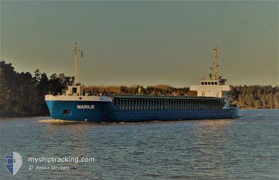
MARILIE
General Cargo
Current Trip
| Time Travelled | 17 h, 18 mins |
|---|---|
| Remaining Time | 15 h, 54 mins |
| Distance Travelled | 139.17 nm |
| Remaining Distance | 146.17 nm |
| AVG Speed | 7.9 Knots |
| MAX Speed | 11.3 Knots |
| AVG Wind | 22.5 knots |
| MAX Wind | 28.8 knots |
| MIN Temp | 7.1°C / 44.78°F |
| MAX Temp | 10.6°C / 51.08°F |
| Draught | 4.9 m |
| Position Received | Now |
Current Position
| Longitude | 1.18720° |
|---|---|
| Latitude | 50.93259° |
| Status | Under way using engine |
| Speed | 9.1 Knots |
| Course | 231.9° |
| Area | English Channel |
| Station | T-AIS |
| Position Received | Now |
Info
Information
The current position of MARILIE is in English Channel with coordinates 50.93259° / 1.18720° as reported on 2024-04-19 22:12 by AIS to our vessel tracker app. The vessel's current speed is 9.1 Knots and is heading at the port of PORTLAND UK. The estimated time of arrival as calculated by MyShipTracking vessel tracking app is 2024-04-20 14:06 LT
The vessel MARILIE (IMO: 9086605, MMSI: 230649000) is a General Cargo that was built in 1995 ( 29 years old ). It's sailing under the flag of [FI] Finland.
In this page you can find informations about the vessels current position, last detected port calls, and current voyage information. If the vessels is not in coverage by AIS you will find the latest position.
The current position of MARILIE is detected by our AIS receivers and we are not responsible for the reliability of the data. The last position was recorded while the vessel was in Coverage by the Ais receivers of our vessel tracking app.
The current draught of MARILIE as reported by AIS is 4.9 meters
Weather
| Temperature | 7°C / 44.6°F |
|---|---|
| Wind Speed | 16 knots |
| Direction | 346° NNW |
| Pressure | 1022.9 hPa |
| Humidity | 63.8 % |
| Cloud Coverage | 37 % |
Featured Company
Last Port Calls
| Port | Arrival | Departure | Time In Port |
|---|---|---|---|
| 2024-04-18 09:08 | 2024-04-19 04:54 | 19 h | |
| 2024-04-11 12:55 | 2024-04-16 17:55 | 5 d | |
| 2024-04-07 22:38 | 2024-04-10 04:51 | 2 d | |
| 2024-03-31 13:43 | 2024-04-06 15:57 | 6 d | |
| 2024-03-30 09:05 | 2024-03-30 10:33 | 1 h | |
| 2024-03-26 23:07 | 2024-03-30 07:39 | 3 d | |
| 2024-03-20 15:15 | 2024-03-25 17:17 | 5 d | |
| 2024-03-17 22:54 | 2024-03-19 10:51 | 1 d | |
| 2024-03-08 15:42 | 2024-03-16 17:28 | 8 d | |
| 2024-03-05 23:56 | 2024-03-07 10:24 | 1 d |
Most Visited Ports (Last year)
| Port | Arrivals | |
|---|---|---|
| 35 | ||
| 34 | ||
| 9 | ||
| 1 | ||
| 1 |
Last Trips
| Origin | Departure | Destination | Arrival | Distance | |
|---|---|---|---|---|---|
| 2024-04-16 18:55 | 2024-04-18 11:08 | 276.55 nm | |||
| 2024-04-10 06:51 | 2024-04-11 13:55 | 270.32 nm | |||
| 2024-04-06 16:57 | 2024-04-08 00:38 | 278.40 nm | |||
| 2024-03-30 11:33 | 2024-03-31 14:43 | 259.81 nm | |||
| 2024-03-30 08:39 | 2024-03-30 10:05 | 9.60 nm | |||
| 2024-03-25 17:17 | 2024-03-27 00:07 | 274.25 nm | |||
| 2024-03-19 11:51 | 2024-03-20 15:15 | 270.78 nm | |||
| 2024-03-16 17:28 | 2024-03-17 23:54 | 273.70 nm | |||
| 2024-03-07 11:24 | 2024-03-08 15:42 | 269.62 nm | |||
| 2024-03-04 20:00 | 2024-03-06 00:56 | 272.95 nm |
Events
| Time | Event | Details | Position / Dest | Info |
|---|---|---|---|---|
| 2024-04-19 20:44 | Change Sea Area | United Kingdom part of the English Channel United Kingdom part of the North Sea |
51.07414 / 1.47014
English Channel
GBPTL
|
Speed: 9.8 kn Course: 231.1° |
| 2024-04-19 17:47 | Change Sea Area | United Kingdom part of the North Sea French part of the North Sea |
51.39870 / 2.05942
North Sea
GBPTL
|
Speed: 7.9 kn Course: 292.4° |
| 2024-04-19 17:26 | Status Changed | Under way using engine Default |
51.38159 / 2.12839
GBPTL
|
Speed: 7 kn Course: 292° |
| 2024-04-19 16:59 | Status Changed | Default Under way using engine |
51.36026 / 2.21974
GBPTL
|
Speed: 8.6 kn Course: 287.5° |
| 2024-04-19 16:50 | Status Changed | Under way using engine Default |
51.35338 / 2.25361
GBPTL
|
Speed: 8.6 kn Course: 283° |
| 2024-04-19 16:48 | Status Changed | Default Under way using engine |
51.35240 / 2.25924
GBPTL
|
Speed: 8.2 kn Course: 285° |
| 2024-04-19 16:43 | Status Changed | Under way using engine Default |
51.34962 / 2.27713
GBPTL
|
Speed: 8.8 kn Course: 282° |
| 2024-04-19 16:40 | Status Changed | Default Under way using engine |
51.34810 / 2.28884
GBPTL
|
Speed: 9.3 kn Course: 268.3° |
| 2024-04-19 16:27 | Change Sea Area | French part of the North Sea Belgian part of the North Sea |
51.35090 / 2.34173
North Sea
GBPTL
|
Speed: 10 kn Course: 255° |
| 2024-04-19 13:07 | Change Sea Area | Belgian part of the North Sea Dutch part of the North Sea |
51.53325 / 3.10078
North Sea
GBPTL
|
Speed: 8.4 kn Course: 224.6° |