
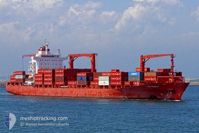
MARGARETE SCHULTE
Container Ship
Current Trip
| Time Travelled | 1 day |
|---|---|
| Remaining Time | 15 days |
| Distance Travelled | 554.93 nm |
| Remaining Distance | 4985.32 nm |
| AVG Speed | 13.8 Knots |
| MAX Speed | 16.7 Knots |
| AVG Wind | 20.3 knots |
| MAX Wind | 27 knots |
| MIN Temp | 7.2°C / 44.96°F |
| MAX Temp | 10.7°C / 51.26°F |
| Draught | 10.2 m |
| Position Received | 1 m ago |
Current Position
| Longitude | -3.20161° |
|---|---|
| Latitude | 49.89680° |
| Status | Under way using engine |
| Speed | 13.6 Knots |
| Course | 239.4° |
| Area | English Channel |
| Station | T-AIS |
| Position Received | 1 m ago |
Info
Information
The current position of MARGARETE SCHULTE is in English Channel with coordinates 49.89680° / -3.20161° as reported on 2024-04-20 03:31 by AIS to our vessel tracker app. The vessel's current speed is 13.6 Knots and is heading at the port of VERACRUZ. The estimated time of arrival as calculated by MyShipTracking vessel tracking app is 2024-05-05 07:31 LT
The vessel MARGARETE SCHULTE (IMO: 9302944, MMSI: 249837000) is a Container Ship that was built in 2006 ( 18 years old ). It's sailing under the flag of [MT] Malta.
In this page you can find informations about the vessels current position, last detected port calls, and current voyage information. If the vessels is not in coverage by AIS you will find the latest position.
The current position of MARGARETE SCHULTE is detected by our AIS receivers and we are not responsible for the reliability of the data. The last position was recorded while the vessel was in Coverage by the Ais receivers of our vessel tracking app.
The current draught of MARGARETE SCHULTE as reported by AIS is 10.2 meters
Weather
| Temperature | 10.5°C / 50.9°F |
|---|---|
| Wind Speed | 16 knots |
| Direction | 81° E |
| Pressure | 1025.4 hPa |
| Humidity | 81.5 % |
| Cloud Coverage | 4 % |
Featured Company
Last Port Calls
| Port | Arrival | Departure | Time In Port |
|---|---|---|---|
| 2024-04-17 03:23 | 2024-04-18 11:11 | 1 d | |
| 2024-04-14 08:07 | 2024-04-16 01:37 | 1 d | |
| 2024-04-12 04:29 | 2024-04-13 11:06 | 1 d | |
| 2024-03-28 21:59 | 2024-03-30 03:21 | 1 d | |
| 2024-03-26 13:31 | 2024-03-26 22:51 | 9 h | |
| 2024-03-22 20:36 | 2024-03-23 11:45 | 15 h | |
| 2024-03-04 04:38 | 2024-03-04 21:30 | 16 h | |
| 2024-03-01 16:13 | 2024-03-03 06:34 | 1 d | |
| 2024-02-28 14:21 | 2024-02-29 17:08 | 1 d | |
| 2024-02-11 03:40 | 2024-02-12 00:44 | 21 h |
Most Visited Ports (Last year)
| Port | Arrivals | |
|---|---|---|
| 11 | ||
| 8 | ||
| 8 | ||
| 8 | ||
| 7 | ||
| 6 |
Last Trips
| Origin | Departure | Destination | Arrival | Distance | |
|---|---|---|---|---|---|
| 2024-04-16 03:37 | 2024-04-17 05:23 | 396.94 nm | |||
| 2024-04-13 12:06 | 2024-04-14 10:07 | 266.70 nm | |||
| 2024-03-29 22:21 | 2024-04-12 05:29 | 4919.35 nm | |||
| 2024-03-26 16:51 | 2024-03-28 16:59 | 822.45 nm | |||
| 2024-03-23 05:45 | 2024-03-26 07:31 | 1135.65 nm | |||
| 2024-03-04 22:30 | 2024-03-22 14:36 | 5841.38 nm | |||
| 2024-03-03 07:34 | 2024-03-04 05:38 | 367.00 nm | |||
| 2024-02-29 17:08 | 2024-03-01 17:13 | 281.76 nm | |||
| 2024-02-11 19:44 | 2024-02-28 14:21 | 4940.44 nm | |||
| 2024-02-02 10:01 | 2024-02-10 22:40 | 2004.90 nm |
Events
| Time | Event | Details | Position / Dest | Info |
|---|---|---|---|---|
| 2024-04-20 02:54 | Change Sea Area | United Kingdom part of the English Channel Guernsey part of the English Channel |
49.97043 / -3.01415
English Channel
MXVER
|
Speed: 14 kn Course: 239.4° |
| 2024-04-20 02:54 | Status Changed | Under way using engine Default |
49.97229 / -3.00955
MXVER
|
Speed: 13.9 kn Course: 238° |
| 2024-04-20 02:46 | Status Changed | Default Under way using engine |
49.98580 / -2.97214
MXVER
|
Speed: 13.2 kn Course: 249° |
| 2024-04-20 02:36 | Status Changed | Under way using engine Default |
49.99952 / -2.91716
MXVER
|
Speed: 13.5 kn Course: 256° |
| 2024-04-20 02:34 | Status Changed | Default Under way using engine |
50.00170 / -2.90610
MXVER
|
Speed: 13.4 kn Course: 252.1° |
| 2024-04-20 02:20 | Status Changed | Under way using engine Default |
50.01571 / -2.82805
MXVER
|
Speed: 13.8 kn Course: 257° |
| 2024-04-20 02:18 | Status Changed | Default Under way using engine |
50.01795 / -2.81557
MXVER
|
Speed: 13.7 kn Course: 253.4° |
| 2024-04-20 00:38 | Change Sea Area | Guernsey part of the English Channel United Kingdom part of the English Channel |
50.12559 / -2.24688
English Channel
MXVER
|
Speed: 13.6 kn Course: 256.6° |
| 2024-04-20 00:36 | Status Changed | Under way using engine Default |
50.12777 / -2.23448
MXVER
|
Speed: 13.5 kn Course: 255° |
| 2024-04-20 00:18 | IN Coverage |
50.12559 / -2.24688
English Channel
MXVER
|
Speed: 13.6 kn Course: 256.6° |