
LIBERTY C
Bulk Carrier
Current Trip
AU DLT
| Time Travelled | 9 days |
|---|---|
| Remaining Time | --- |
| Distance Travelled | 2573.78 nm |
| Remaining Distance | --- |
| AVG Speed | 10.7 Knots |
| MAX Speed | 14.6 Knots |
| AVG Wind | 12.9 knots |
| MAX Wind | 20.8 knots |
| MIN Temp | 18.5°C / 65.3°F |
| MAX Temp | 30.1°C / 86.18°F |
| Draught | 7.2 m |
| Position Received | 8 d ago |
Current Position
| Longitude | 149.99249° |
|---|---|
| Latitude | -21.02694° |
| Status | Under way using engine |
| Speed | 11.3 Knots |
| Course | 320.7° |
| Area | Coral Sea |
| Station | T-AIS |
| Position Received | 8 d ago |
Info
Information
The current position of LIBERTY C is in Coral Sea with coordinates -21.02694° / 149.99249° as reported on 2024-04-09 13:12 by AIS to our vessel tracker app. The vessel's current speed is 11.3 Knots
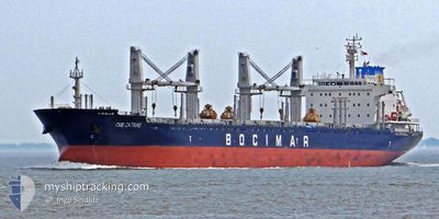
The vessel LIBERTY C (IMO: 9597977, MMSI: 636019312) is a Bulk Carrier that was built in 2012 ( 12 years old ). It's sailing under the flag of [LR] Liberia.
In this page you can find informations about the vessels current position, last detected port calls, and current voyage information. If the vessels is not in coverage by AIS you will find the latest position.
The current position of LIBERTY C is detected by our AIS receivers and we are not responsible for the reliability of the data. The last position was recorded while the vessel was in Coverage by the Ais receivers of our vessel tracking app.
The current draught of LIBERTY C as reported by AIS is 7.2 meters
Weather
| Temperature | 29.3°C / 84.74°F |
|---|---|
| Wind Speed | 3 knots |
| Direction | 161° SSE |
| Pressure | 1007.2 hPa |
| Humidity | 69.4 % |
| Cloud Coverage | 78 % |
Featured Company
Last Port Calls
| Port | Arrival | Departure | Time In Port |
|---|---|---|---|
| 2024-04-04 05:58 | 2024-04-08 18:15 | 4 d | |
| 2024-03-27 22:08 | 2024-04-02 10:09 | 5 d | |
| 2024-03-09 00:03 | 2024-03-13 14:54 | 4 d | |
| 2024-02-19 13:41 | 2024-02-21 12:54 | 1 d |
Most Visited Ports (Last year)
| Port | Arrivals | |
|---|---|---|
| 2 | ||
| 2 | ||
| 1 | ||
| 1 | ||
| 1 | ||
| 1 |
Last Trips
| Origin | Departure | Destination | Arrival | Distance | |
|---|---|---|---|---|---|
| 2024-04-02 20:09 | 2024-04-04 15:58 | 451.89 nm | |||
| 2024-03-13 23:54 | 2024-03-28 08:08 | 3763.47 nm | |||
| 2024-02-21 20:54 | 2024-03-09 09:03 | 1249.75 nm | |||
| 2023-12-19 16:35 | 2024-02-19 21:41 | 9634.49 nm |
Events
| Time | Event | Details | Position / Dest | Info |
|---|---|---|---|---|
| 2024-04-09 13:14 | Status Changed | Default Under way using engine |
-21.02080 / 149.98721
AU DLT
|
Speed: 11.3 kn Course: 320.7° |
| 2024-04-09 13:12 | OUT of Coverage |
-21.02694 / 149.99249
Coral Sea
|
Speed: 11.3 kn Course: 320.7° |
|
| 2024-04-09 13:08 | Status Changed | Under way using engine Default |
-21.03587 / 150.00028
AU DLT
|
Speed: 11 kn Course: 319° |
| 2024-04-09 13:08 | IN Coverage |
-21.03261 / 149.99747
Coral Sea
|
Speed: 11.3 kn Course: 320.9° |
|
| 2024-04-08 19:00 | Status Changed | Default Under way using engine |
-23.90670 / 151.40189
AU DLT
|
Speed: 8.7 kn Course: 125.1° |
| 2024-04-08 18:49 | OUT of Coverage |
-23.89194 / 151.37696
Coral Sea
|
Speed: 8.7 kn Course: 125.1° |
|
| 2024-04-08 18:46 | Status Changed | Under way using engine Default |
-23.88789 / 151.37043
AU DLT
|
Speed: 8.7 kn Course: 135° |
| 2024-04-08 18:44 | Status Changed | Default Under way using engine |
-23.88440 / 151.36571
AU DLT
|
Speed: 9.4 kn Course: 132.4° |
| 2024-04-08 18:15 | PORT DEPARTURE |
|
-23.84349 / 151.29782
AU DLT
|
Speed: 10.2 kn Course: 113° |
| 2024-04-08 18:01 | START Moving |
-23.83236 / 151.26593
[AU] GLADSTONE
|
Speed: 3.2 kn Course: 97° |