
LIA
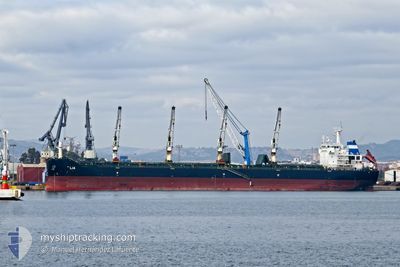
Bulk Carrier
Current Trip
| Trip Time | 19 days |
|---|---|
| Trip Distance | 4651.78 nm |
| AVG Speed | 10.2 Knots |
| MAX Speed | 14.5 Knots |
| Draught | 6.5 m |
| AVG Wind | 18.2 knots |
| MAX Wind | 40 knots |
| MIN Temp | 3.7°C / 38.66°F |
| MAX Temp | 19.3°C / 66.74°F |
| Position Received | 1 d ago |
Current Position
| Longitude | -122.80116° |
|---|---|
| Latitude | 45.88744° |
| Status | Under way using engine |
| Speed | 10.6 Knots |
| Course | 157.2° |
| Area | North Pacific Ocean |
| Station | T-AIS |
| Position Received | 1 d ago |
Info
Information
The current position of LIA is in North Pacific Ocean with coordinates 45.88744° / -122.80116° as reported on 2024-04-15 05:35 by AIS to our vessel tracker app. The vessel's current speed is 10.6 Knots and is currently inside the port of PORTLAND.
The vessel LIA (IMO: 9584152, MMSI: 215218000) is a Bulk Carrier that was built in 2011 ( 13 years old ). It's sailing under the flag of [MT] Malta.
In this page you can find informations about the vessels current position, last detected port calls, and current voyage information. If the vessels is not in coverage by AIS you will find the latest position.
The current position of LIA is detected by our AIS receivers and we are not responsible for the reliability of the data. The last position was recorded while the vessel was in Coverage by the Ais receivers of our vessel tracking app.
The current draught of LIA as reported by AIS is 6.5 meters
Weather
| Temperature | 6.6°C / 43.88°F |
|---|---|
| Wind Speed | 1 knots |
| Direction | 237° WSW |
| Pressure | 1028.4 hPa |
| Humidity | 73.6 % |
| Cloud Coverage | 100 % |
Featured Company
Last Port Calls
Most Visited Ports (Last year)
| Port | Arrivals | |
|---|---|---|
| 2 | ||
| 2 | ||
| 1 | ||
| 1 | ||
| 1 | ||
| 1 |
Last Trips
| Origin | Departure | Destination | Arrival | Distance | |
|---|---|---|---|---|---|
| 2024-03-28 15:28 | 2024-04-16 04:25 | 4651.78 nm | |||
| 2024-03-21 20:28 | 2024-03-25 05:52 | 416.14 nm | |||
| 2024-03-06 05:32 | 2024-03-15 07:25 | 990.20 nm | |||
| 2024-02-14 22:18 | 2024-03-05 21:49 | 3894.31 nm | |||
| 2024-01-21 04:04 | 2024-02-12 16:13 | 5136.70 nm |
Events
| Time | Event | Details | Position / Dest | Info |
|---|---|---|---|---|
| 2024-04-16 12:47 | STOP Moving |
45.53500 / -122.67667
[US] PORTLAND
|
Speed: Course: -1° |
|
| 2024-04-16 11:25 | PORT ARRIVAL |
|
45.64619 / -122.77089
[US] PORTLAND
|
Speed: 6.8 kn Course: 207° |
| 2024-04-16 11:08 | START Moving | 1.5 nm, West of VANCOUVER |
45.64500 / -122.74167
US PDX
|
Speed: 5 kn Course: 294° |
| 2024-04-15 07:50 | STOP Moving | 1.06 nm, West of VANCOUVER |
45.64102 / -122.73258
US PDX
|
Speed: Course: 117° |
| 2024-04-15 05:38 | Status Changed | Default Under way using engine |
45.87833 / -122.79333
US PDX
|
Speed: 10.6 kn Course: 157.2° |
| 2024-04-15 05:35 | OUT of Coverage |
45.88744 / -122.80116
North Pacific Ocean
|
Speed: 10.6 kn Course: 157.2° |
|
| 2024-04-14 19:39 | Draught Changed | 6.5 12.3 |
46.01732 / -124.73128
US PDX
|
Speed: 10.3 kn Course: 73° |
| 2024-04-14 19:39 | Destination Changed | US PDX YATSHUMIRO |
46.01732 / -124.73128
US PDX
|
Speed: 10.3 kn Course: 73° |
| 2024-04-14 19:39 | ETA Changed | 2024/04/14 23:00 2024/03/09 12:00 |
46.01732 / -124.73128
US PDX
|
Speed: 10.3 kn Course: 73° |
| 2024-04-14 19:16 | Detected in Sea | United States part of the North Pacific Ocean |
45.99626 / -124.82214
North Pacific Ocean
|
Speed: 10.6 kn Course: 71.6° |