
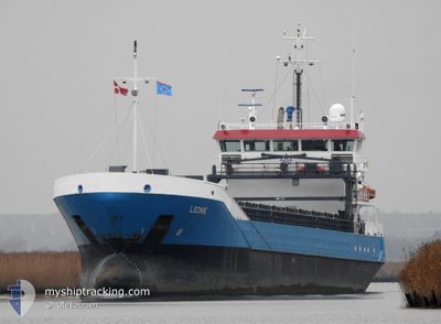
LEONIE
General Cargo
Current Trip
| Time Travelled | 5 days |
|---|---|
| Remaining Time | --- |
| Distance Travelled | 1055.33 nm |
| Remaining Distance | --- |
| AVG Speed | 8.5 Knots |
| MAX Speed | 12 Knots |
| AVG Wind | 14.8 knots |
| MAX Wind | 32 knots |
| MIN Temp | -0.3°C / 31.46°F |
| MAX Temp | 9.9°C / 49.82°F |
| Draught | 5.6 m |
| Position Received | 9 m ago |
Current Position
| Longitude | 26.90045° |
|---|---|
| Latitude | 60.41987° |
| Status | Moored |
| Speed | |
| Course | 322° |
| Area | Gulf of Finland |
| Station | T-AIS |
| Position Received | 9 m ago |
Info
Information
The current position of LEONIE is in Gulf of Finland with coordinates 60.41987° / 26.90045° as reported on 2024-04-24 04:42 by AIS to our vessel tracker app. The vessel's current speed is 0 Knots
The vessel LEONIE (IMO: 9331361, MMSI: 244772000) is a General Cargo that was built in 2007 ( 17 years old ). It's sailing under the flag of [NL] Netherlands.
In this page you can find informations about the vessels current position, last detected port calls, and current voyage information. If the vessels is not in coverage by AIS you will find the latest position.
The current position of LEONIE is detected by our AIS receivers and we are not responsible for the reliability of the data. The last position was recorded while the vessel was in Coverage by the Ais receivers of our vessel tracking app.
The current draught of LEONIE as reported by AIS is 5.6 meters
Weather
| Temperature | 0.9°C / 33.62°F |
|---|---|
| Wind Speed | 14 knots |
| Direction | 218° SW |
| Pressure | 1015.4 hPa |
| Humidity | 86.8 % |
| Cloud Coverage | 100 % |
Featured Company
Last Port Calls
| Port | Arrival | Departure | Time In Port |
|---|---|---|---|
| 2024-04-18 02:12 | 2024-04-18 15:22 | 13 h | |
| 2024-04-14 01:19 | 2024-04-18 01:32 | 4 d | |
| 2024-03-26 05:41 | 2024-04-08 19:13 | 13 d | |
| 2024-03-19 23:29 | 2024-03-20 15:27 | 15 h | |
| 2024-03-18 09:25 | 2024-03-19 10:50 | 1 d | |
| 2024-03-15 11:02 | 2024-03-16 11:15 | 1 d | |
| 2024-03-13 13:29 | 2024-03-14 18:16 | 1 d | |
| 2024-03-08 14:11 | 2024-03-11 13:25 | 2 d | |
| 2024-03-04 16:58 | 2024-03-07 13:31 | 2 d | |
| 2024-03-02 21:16 |
Last Trips
| Origin | Departure | Destination | Arrival | Distance | |
|---|---|---|---|---|---|
| 2024-04-18 03:32 | 2024-04-18 04:12 | 8.89 nm | |||
| 2024-04-08 22:13 | 2024-04-14 03:19 | 1079.43 nm | |||
| 2024-03-20 16:27 | 2024-03-26 07:41 | 888.50 nm | |||
| 2024-03-19 11:50 | 2024-03-20 00:29 | 139.04 nm | |||
| 2024-03-16 12:15 | 2024-03-18 10:25 | 363.09 nm | |||
| 2024-03-14 19:16 | 2024-03-15 12:02 | 172.79 nm | |||
| 2024-03-11 14:25 | 2024-03-13 14:29 | 421.90 nm | |||
| 2024-03-07 14:31 | 2024-03-08 15:11 | 176.06 nm | |||
| 2024-03-01 16:33 | 2024-03-02 22:16 | 110.10 nm | |||
| 2024-02-21 20:15 | 2024-02-28 17:29 | 1414.75 nm |
Events
| Time | Event | Details | Position / Dest | Info |
|---|---|---|---|---|
| 2024-04-24 01:03 | Status Changed | Moored Default |
60.41987 / 26.90039
FIKTK
|
Speed: Course: 321° |
| 2024-04-24 00:54 | Status Changed | Default Moored |
60.41992 / 26.90045
FIKTK
|
Speed: Course: 322° |
| 2024-04-23 19:33 | Status Changed | Moored Under way using engine |
60.41991 / 26.90041
FIKTK
|
Speed: Course: 322° |
| 2024-04-23 19:17 | ETA Changed | 2024/04/23 22:00 2024/04/23 04:00 |
60.41989 / 26.90043
FIKTK
|
Speed: Course: 322° |
| 2024-04-23 19:09 | STOP Moving | 3.93 nm, South West of KOTKA |
60.41986 / 26.90051
FIKTK
|
Speed: 0.3 kn Course: 321° |
| 2024-04-23 15:48 | Status Changed | Under way using engine Default |
60.08086 / 26.20020
FIKTK
|
Speed: 9.9 kn Course: 27° |
| 2024-04-23 15:48 | IN Coverage |
60.08267 / 26.20326
Gulf of Finland
|
Speed: 9.7 kn Course: 42.6° |
|
| 2024-04-23 13:52 | Status Changed | Default Under way using engine |
59.87422 / 25.74053
FIKTK
|
Speed: 10.2 kn Course: 84.9° |
| 2024-04-23 13:46 | Change Sea Area | Finnish part of the Gulf of Finland Estonian part of the Gulf of Finland |
59.87103 / 25.70661
Gulf of Finland
|
Speed: 10.2 kn Course: 84.9° |
| 2024-04-23 13:46 | OUT of Coverage |
59.87103 / 25.70661
Gulf of Finland
|
Speed: 10.2 kn Course: 84.9° |