
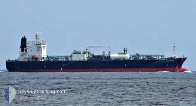
LEO SUNRISE
Tanker
Current Trip
| Time Travelled | 8 days |
|---|---|
| Remaining Time | --- |
| Distance Travelled | 2749.53 nm |
| Remaining Distance | --- |
| AVG Speed | 13.6 Knots |
| MAX Speed | 17.3 Knots |
| AVG Wind | 9.9 knots |
| MAX Wind | 24 knots |
| MIN Temp | 27.2°C / 80.96°F |
| MAX Temp | 29.9°C / 85.82°F |
| Draught | 10.3 m |
| Position Received | 13 h, 2 m ago |
Current Position
| Longitude | 141.94299° |
|---|---|
| Latitude | -10.57387° |
| Status | Under way using engine |
| Speed | 11.5 Knots |
| Course | 87.3° |
| Area | Arafura Sea |
| Station | T-AIS |
| Position Received | 13 h, 2 m ago |
Info
Information
The current position of LEO SUNRISE is in Arafura Sea with coordinates -10.57387° / 141.94299° as reported on 2024-04-16 10:51 by AIS to our vessel tracker app. The vessel's current speed is 11.5 Knots and is heading at the port of GLADSTONE. The estimated time of arrival as calculated by MyShipTracking vessel tracking app is 2024-04-19 17:00 LT
The vessel LEO SUNRISE (IMO: 9678525, MMSI: 565099000) is a Tanker It's sailing under the flag of [SG] Singapore.
In this page you can find informations about the vessels current position, last detected port calls, and current voyage information. If the vessels is not in coverage by AIS you will find the latest position.
The current position of LEO SUNRISE is detected by our AIS receivers and we are not responsible for the reliability of the data. The last position was recorded while the vessel was in Coverage by the Ais receivers of our vessel tracking app.
The current draught of LEO SUNRISE as reported by AIS is 10.3 meters
Weather
| Temperature | 27.3°C / 81.14°F |
|---|---|
| Wind Speed | 14 knots |
| Direction | 120° ESE |
| Pressure | 1011.3 hPa |
| Humidity | 85.1 % |
| Cloud Coverage | 99 % |
Featured Company
Last Port Calls
| Port | Arrival | Departure | Time In Port |
|---|---|---|---|
| 2024-04-07 23:16 | 2024-04-08 22:41 | 23 h | |
| 2024-03-31 08:23 | 2024-04-01 23:47 | 1 d | |
| 2024-03-22 09:16 | 2024-03-27 23:16 | 5 d | |
| 2024-03-18 00:40 | 2024-03-19 11:27 | 1 d | |
| 2024-02-28 03:58 | 2024-02-29 07:11 | 1 d | |
| 2024-02-24 06:59 | 2024-02-25 00:05 | 17 h | |
| 2024-02-12 23:02 | 2024-02-14 05:04 | 1 d | |
| 2024-02-07 10:33 | 2024-02-10 00:05 | 2 d |
Last Trips
| Origin | Departure | Destination | Arrival | Distance | |
|---|---|---|---|---|---|
| 2024-04-02 07:47 | 2024-04-08 07:16 | 1749.09 nm | |||
| 2024-03-28 07:16 | 2024-03-31 16:23 | 923.57 nm | |||
| 2024-03-19 19:27 | 2024-03-22 17:16 | 931.65 nm | |||
| 2024-02-29 14:11 | 2024-03-18 08:40 | 1250.89 nm | |||
| 2024-02-25 08:05 | 2024-02-28 10:58 | 1024.41 nm | |||
| 2024-02-14 15:04 | 2024-02-24 14:59 | 2789.41 nm | |||
| 2024-02-10 11:05 | 2024-02-13 09:02 | 692.64 nm | |||
| 2024-01-28 16:08 | 2024-02-07 21:33 | 3129.94 nm |
Events
| Time | Event | Details | Position / Dest | Info |
|---|---|---|---|---|
| 2024-04-16 10:58 | Status Changed | Default Under way using engine |
-10.57260 / 141.96565
AU GLT
|
Speed: 11.5 kn Course: 87.3° |
| 2024-04-16 10:51 | Change Sea Area | Australian part of the Arafura Sea Indonesian part of the Flores Sea |
-10.57387 / 141.94299
Arafura Sea
AU GLT
|
Speed: 11.5 kn Course: 87.3° |
| 2024-04-16 10:51 | Status Changed | Under way using engine Default |
-10.57387 / 141.94299
AU GLT
|
Speed: 11.4 kn Course: 87° |
| 2024-04-16 10:51 | OUT of Coverage |
-10.57387 / 141.94299
Arafura Sea
AU GLT
|
Speed: 11.5 kn Course: 87.3° |
|
| 2024-04-16 10:33 | IN Coverage |
-10.57387 / 141.94299
Arafura Sea
AU GLT
|
Speed: 11.5 kn Course: 87.3° |
|
| 2024-04-11 22:54 | Status Changed | Default Under way using engine |
-7.97427 / 117.46890
AU GLT
|
Speed: 15.8 kn Course: 86.8° |
| 2024-04-11 22:52 | OUT of Coverage |
-7.97484 / 117.45960
Flores Sea
AU GLT
|
Speed: 15.8 kn Course: 86.8° |
|
| 2024-04-11 21:53 | Change Sea Area | Indonesian part of the Flores Sea Malaysian part of the South China Sea |
-7.99085 / 117.20925
Flores Sea
AU GLT
|
Speed: 15 kn Course: 86.5° |
| 2024-04-11 21:53 | Status Changed | Under way using engine Default |
-7.99085 / 117.20925
AU GLT
|
Speed: 15 kn Course: 87° |
| 2024-04-11 21:39 | IN Coverage |
-7.99085 / 117.20925
Flores Sea
AU GLT
|
Speed: 15 kn Course: 86.5° |