
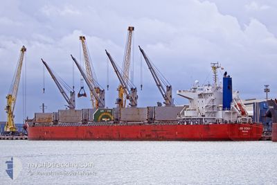
LEO OCEAN
Cargo
Current Trip
CN TXG
| Time Travelled | 10 h, 45 mins |
|---|---|
| Remaining Time | --- |
| Distance Travelled | 128.28 nm |
| Remaining Distance | --- |
| AVG Speed | 12.2 Knots |
| MAX Speed | 13.4 Knots |
| AVG Wind | 16.1 knots |
| MAX Wind | 23 knots |
| MIN Temp | 10.7°C / 51.26°F |
| MAX Temp | 17.1°C / 62.78°F |
| Draught | 7 m |
| Position Received | 6 h, 57 m ago |
Current Position
| Longitude | 118.79444° |
|---|---|
| Latitude | 38.78017° |
| Status | Under way using engine |
| Speed | 13.3 Knots |
| Course | 93.6° |
| Area | Yellow Sea |
| Station | T-AIS |
| Position Received | 6 h, 57 m ago |
Info
Information
The current position of LEO OCEAN is in Yellow Sea with coordinates 38.78017° / 118.79444° as reported on 2024-04-25 12:40 by AIS to our vessel tracker app. The vessel's current speed is 13.3 Knots
The vessel LEO OCEAN (IMO: 9738923, MMSI: 371004000) is a Cargo It's sailing under the flag of [PA] Panama.
In this page you can find informations about the vessels current position, last detected port calls, and current voyage information. If the vessels is not in coverage by AIS you will find the latest position.
The current position of LEO OCEAN is detected by our AIS receivers and we are not responsible for the reliability of the data. The last position was recorded while the vessel was in Coverage by the Ais receivers of our vessel tracking app.
The current draught of LEO OCEAN as reported by AIS is 7 meters
Weather
| Temperature | 11.1°C / 51.98°F |
|---|---|
| Wind Speed | 16 knots |
| Direction | 199° SSW |
| Pressure | 1005.2 hPa |
| Humidity | 75.8 % |
| Cloud Coverage | 5 % |
Featured Company
Last Port Calls
| Port | Arrival | Departure | Time In Port |
|---|---|---|---|
| 2024-04-21 12:44 | 2024-04-25 08:52 | 3 d | |
| 2024-03-26 20:00 | 2024-03-28 12:56 | 1 d | |
| 2024-02-27 22:53 | 2024-03-04 19:44 | 5 d | |
| 2024-02-23 22:33 | 2024-02-26 00:37 | 2 d | |
| 2024-02-06 10:02 | 2024-02-08 03:14 | 1 d | |
| 2024-02-03 23:14 | 2024-02-05 11:10 | 1 d |
Last Trips
| Origin | Departure | Destination | Arrival | Distance | |
|---|---|---|---|---|---|
| 2024-03-28 20:56 | 2024-04-21 20:44 | 1806.44 nm | |||
| 2024-03-04 11:44 | 2024-03-27 04:00 | 5556.49 nm | |||
| 2024-02-25 16:37 | 2024-02-27 14:53 | 434.76 nm | |||
| 2024-02-08 12:14 | 2024-02-23 14:33 | 4285.40 nm | |||
| 2024-02-05 20:10 | 2024-02-06 19:02 | 63.90 nm | |||
| 2023-12-05 01:39 | 2024-02-04 08:14 | 6357.58 nm |
Events
| Time | Event | Details | Position / Dest | Info |
|---|---|---|---|---|
| 2024-04-25 12:48 | Status Changed | Default Under way using engine |
38.77725 / 118.83367
CN TXG
|
Speed: 13.3 kn Course: 93.6° |
| 2024-04-25 12:40 | OUT of Coverage |
38.78017 / 118.79444
Yellow Sea
|
Speed: 13.3 kn Course: 93.6° |
|
| 2024-04-25 11:55 | Status Changed | Under way using engine Default |
38.79904 / 118.59381
CN TXG
|
Speed: 12.4 kn Course: 135° |
| 2024-04-25 11:44 | IN Coverage |
38.79791 / 118.59794
Yellow Sea
|
Speed: 12.2 kn Course: 103.6° |
|
| 2024-04-25 08:52 | PORT DEPARTURE |
|
38.95712 / 117.87465
CN TXG
|
Speed: 10.7 kn Course: 101° |
| 2024-04-25 07:52 | START Moving |
39.04212 / 117.76917
[CN] TIANJIN
|
Speed: 3.6 kn Course: 186° |
|
| 2024-04-21 12:44 | STOP Moving |
39.04680 / 117.77198
[CN] TIANJIN
|
Speed: 0.2 kn Course: 114° |
|
| 2024-04-21 12:44 | PORT ARRIVAL |
|
39.04680 / 117.77198
[CN] TIANJIN
|
Speed: 3.2 kn Course: 32° |
| 2024-04-21 10:28 | START Moving | 17.37 nm, East of TIANJIN |
38.94349 / 118.11594
CN TXG
|
Speed: 7.7 kn Course: 228° |
| 2024-04-19 17:55 | STOP Moving | 17.68 nm, East of TIANJIN |
38.94667 / 118.12334
CN TXG
|
Speed: Course: -1° |