
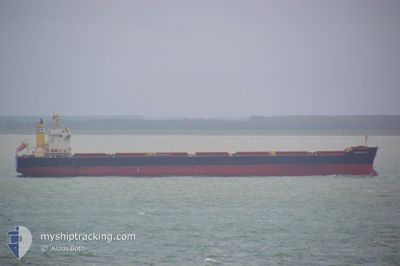
KYPROS SKY
Cargo
Current Trip
| Time Travelled | 18 days |
|---|---|
| Remaining Time | -13 mins |
| Distance Travelled | 1637.92 nm |
| Remaining Distance | 34.15 nm |
| AVG Speed | 9.9 Knots |
| MAX Speed | 14.4 Knots |
| AVG Wind | 14.7 knots |
| MAX Wind | 27.9 knots |
| MIN Temp | 19.7°C / 67.46°F |
| MAX Temp | 26.1°C / 78.98°F |
| Draught | 8 m |
| Position Received | 2 h, 32 m ago |
Current Position
| Longitude | -88.06724° |
|---|---|
| Latitude | 30.06455° |
| Status | At anchor |
| Speed | 1.5 Knots |
| Course | 275° |
| Area | Gulf of Mexico |
| Station | T-AIS |
| Position Received | 2 h, 32 m ago |
Info
Information
The current position of KYPROS SKY is in Gulf of Mexico with coordinates 30.06455° / -88.06724° as reported on 2024-04-17 20:37 by AIS to our vessel tracker app. The vessel's current speed is 1.5 Knots and is heading at the port of MOBILE. The estimated time of arrival as calculated by MyShipTracking vessel tracking app is 2024-04-17 22:57 LT
The vessel KYPROS SKY (IMO: 9713935, MMSI: 212452000) is a Cargo It's sailing under the flag of [CY] Cyprus.
In this page you can find informations about the vessels current position, last detected port calls, and current voyage information. If the vessels is not in coverage by AIS you will find the latest position.
The current position of KYPROS SKY is detected by our AIS receivers and we are not responsible for the reliability of the data. The last position was recorded while the vessel was in Coverage by the Ais receivers of our vessel tracking app.
The current draught of KYPROS SKY as reported by AIS is 8 meters
Weather
| Temperature | 22.5°C / 72.5°F |
|---|---|
| Wind Speed | 12 knots |
| Direction | 157° SSE |
| Pressure | 1017.4 hPa |
| Humidity | 88.1 % |
| Cloud Coverage | 90 % |
Featured Company
Last Port Calls
| Port | Arrival | Departure | Time In Port |
|---|---|---|---|
| 2024-03-26 23:18 | 2024-03-30 16:15 | 3 d | |
| 2024-02-02 08:29 |
Last Trips
| Origin | Departure | Destination | Arrival | Distance | |
|---|---|---|---|---|---|
| 2024-02-02 16:29 | 2024-03-26 18:18 | 14564.23 nm |
Events
| Time | Event | Details | Position / Dest | Info |
|---|---|---|---|---|
| 2024-04-17 20:58 | STOP Moving | 11.19 nm, South of DAUPHIN ISLAND |
30.06533 / -88.06657
USMOB
|
Speed: 0.3 kn Course: 259° |
| 2024-04-17 20:43 | Status Changed | Default At anchor |
30.06479 / -88.06619
USMOB
|
Speed: 1.5 kn Course: 275° |
| 2024-04-17 20:37 | Status Changed | At anchor Under way using engine |
30.06455 / -88.06724
USMOB
|
Speed: 1.7 kn Course: 272° |
| 2024-04-17 20:37 | OUT of Coverage |
30.06455 / -88.06724
Gulf of Mexico
USMOB
|
Speed: 1.5 kn Course: 88.9° |
|
| 2024-04-17 20:36 | Status Changed | Under way using engine Default |
30.06453 / -88.06809
USMOB
|
Speed: 1.8 kn Course: 270° |
| 2024-04-17 20:35 | Status Changed | Default Under way using engine |
30.06451 / -88.06848
USMOB
|
Speed: 0.9 kn Course: 232° |
| 2024-04-17 20:29 | Status Changed | Under way using engine Default |
30.06424 / -88.07071
USMOB
|
Speed: 2 kn Course: 226° |
| 2024-04-17 20:27 | Status Changed | Default Under way using engine |
30.06477 / -88.07011
USMOB
|
Speed: 4.1 kn Course: 236° |
| 2024-04-17 20:00 | Status Changed | Under way using engine Default |
30.06871 / -88.03479
USMOB
|
Speed: 5.9 kn Course: 264° |
| 2024-04-17 19:55 | IN Coverage |
30.06851 / -88.03748
Gulf of Mexico
USMOB
|
Speed: 4.9 kn Course: 265.2° |