
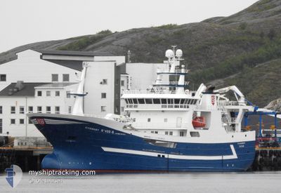
KVANNOY
Fishing
Current Trip
| Trip Time | 2 days |
|---|---|
| Trip Distance | 870.68 nm |
| AVG Speed | 13.2 Knots |
| MAX Speed | 15.9 Knots |
| Draught | 7.8 m |
| AVG Wind | 10.9 knots |
| MAX Wind | 28.4 knots |
| MIN Temp | -1.3°C / 29.66°F |
| MAX Temp | 6°C / 42.8°F |
| Position Received | Now |
Current Position
| Longitude | 14.38912° |
|---|---|
| Latitude | 67.29533° |
| Status | Under way using engine |
| Speed | |
| Course | 213° |
| Area | Norwegian Sea |
| Station | T-AIS |
| Position Received | Now |
Info
Information
The current position of KVANNOY is in Norwegian Sea with coordinates 67.29533° / 14.38912° as reported on 2024-04-25 19:25 by AIS to our vessel tracker app. The vessel's current speed is 0 Knots and is currently inside the port of BODOE.
The vessel KVANNOY (IMO: 9710919, MMSI: 257997000) is a Fishing It's sailing under the flag of [NO] Norway.
In this page you can find informations about the vessels current position, last detected port calls, and current voyage information. If the vessels is not in coverage by AIS you will find the latest position.
The current position of KVANNOY is detected by our AIS receivers and we are not responsible for the reliability of the data. The last position was recorded while the vessel was in Coverage by the Ais receivers of our vessel tracking app.
The current draught of KVANNOY as reported by AIS is 7.8 meters
Weather
| Temperature | 3.6°C / 38.48°F |
|---|---|
| Wind Speed | 8 knots |
| Direction | 102° ESE |
| Pressure | 1010.2 hPa |
| Humidity | 64 % |
| Cloud Coverage | 100 % |
Featured Company
Last Port Calls
| Port | Arrival | Departure | Time In Port |
|---|---|---|---|
| 2024-04-21 08:05 | |||
| 2024-04-03 13:26 | 2024-04-18 12:52 | 14 d | |
| 2024-04-01 16:48 | 2024-04-02 14:22 | 21 h | |
| 2024-03-30 08:27 | 2024-04-01 14:52 | 2 d | |
| 2024-03-21 17:15 | 2024-03-21 18:24 | 1 h | |
| 2024-03-20 21:12 | 2024-03-21 16:44 | 19 h | |
| 2024-03-13 18:16 | 2024-03-13 19:42 | 1 h | |
| 2024-03-13 12:14 | 2024-03-13 17:45 | 5 h | |
| 2024-03-02 08:37 | 2024-03-03 07:21 | 22 h | |
| 2024-02-20 17:43 | 2024-02-20 18:20 | 37 m |
Most Visited Ports (Last year)
| Port | Arrivals | |
|---|---|---|
| 15 | ||
| 11 | ||
| 7 | ||
| 6 | ||
| 2 | ||
| 2 |
Last Trips
| Origin | Departure | Destination | Arrival | Distance | |
|---|---|---|---|---|---|
| 2024-04-18 14:52 | 2024-04-21 10:05 | 870.68 nm | |||
| 2024-04-02 16:22 | 2024-04-03 15:26 | 256.35 nm | |||
| 2024-04-01 16:52 | 2024-04-01 18:48 | 15.44 nm | |||
| 2024-03-21 19:24 | 2024-03-30 09:27 | 763.07 nm | |||
| 2024-03-21 17:44 | 2024-03-21 18:15 | 4.39 nm | |||
| 2024-03-13 20:42 | 2024-03-20 22:12 | 624.17 nm | |||
| 2024-03-13 18:45 | 2024-03-13 19:16 | 4.65 nm | |||
| 2024-03-03 08:21 | 2024-03-13 13:14 | 1515.68 nm | |||
| 2024-02-20 19:20 | 2024-03-02 09:37 | 1060.67 nm | |||
| 2024-02-20 18:13 | 2024-02-20 18:43 | 4.89 nm |
Events
| Time | Event | Details | Position / Dest | Info |
|---|---|---|---|---|
| 2024-04-21 08:22 | STOP Moving |
67.29526 / 14.38932
[NO] BODOE
|
Speed: 0.3 kn Course: 215° |
|
| 2024-04-21 08:05 | PORT ARRIVAL |
|
67.28559 / 14.36576
[NO] BODOE
|
Speed: 5.4 kn Course: 67.6° |
| 2024-04-21 01:31 | Destination Changed | CH 16 FOR INFO FREDERIKSHAVN |
66.12014 / 12.75847
CH 16 FOR INFO
|
Speed: 13 kn Course: 41.8° |
| 2024-04-21 01:31 | ETA Changed | 2025/03/21 12:34 2024/04/04 15:00 |
66.12014 / 12.75847
CH 16 FOR INFO
|
Speed: 13 kn Course: 41.8° |
| 2024-04-19 17:28 | Change Sea Area | Norwegian part of the Norwegian Sea Norwegian part of the North Sea |
61.00769 / 4.63256
Norwegian Sea
|
Speed: 13 kn Course: 346.8° |
| 2024-04-19 01:32 | Change Sea Area | Norwegian part of the North Sea Norwegian part of the Skaggerak |
57.93609 / 7.10342
North Sea
|
Speed: 14.5 kn Course: 281.9° |
| 2024-04-18 21:05 | Change Sea Area | Norwegian part of the Skaggerak Danish part of the Skaggerak |
57.85090 / 9.13494
Skaggerak
|
Speed: 14.3 kn Course: 272.3° |
| 2024-04-18 17:20 | Change Sea Area | Danish part of the Skaggerak Danish part of the Kattegat |
57.76593 / 10.74627
Skaggerak
|
Speed: 14.7 kn Course: 332° |
| 2024-04-18 15:32 | START Moving | 0.42 nm, South East of FREDERIKSHAVN |
57.43152 / 10.55906
FREDERIKSHAVN
|
Speed: 4 kn Course: 184° |
| 2024-04-18 12:56 | STOP Moving | 0.42 nm, East of FREDERIKSHAVN |
57.43333 / 10.56034
FREDERIKSHAVN
|
Speed: 0.2 kn Course: 176° |