
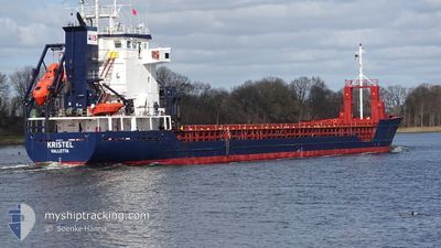
KRISTEL
General Cargo
Current Trip
| Time Travelled | 12 h, 22 mins |
|---|---|
| Remaining Time | 2 days |
| Distance Travelled | 97.92 nm |
| Remaining Distance | 626.76 nm |
| AVG Speed | 10.5 Knots |
| MAX Speed | 11.3 Knots |
| AVG Wind | 19.7 knots |
| MAX Wind | 22.6 knots |
| MIN Temp | -1.6°C / 29.12°F |
| MAX Temp | -1°C / 30.2°F |
| Draught | 6.2 m |
| Position Received | 40 m ago |
Current Position
| Longitude | 26.20053° |
|---|---|
| Latitude | 59.98004° |
| Status | Under way using engine |
| Speed | 10.7 Knots |
| Course | 256.3° |
| Area | Gulf of Finland |
| Station | T-AIS |
| Position Received | 40 m ago |
Info
Information
The current position of KRISTEL is in Gulf of Finland with coordinates 59.98004° / 26.20053° as reported on 2024-04-19 21:24 by AIS to our vessel tracker app. The vessel's current speed is 10.7 Knots and is heading at the port of WISMAR. The estimated time of arrival as calculated by MyShipTracking vessel tracking app is 2024-04-22 10:36 LT
The vessel KRISTEL (IMO: 9191747, MMSI: 229246000) is a General Cargo that was built in 1999 ( 25 years old ). It's sailing under the flag of [MT] Malta.
In this page you can find informations about the vessels current position, last detected port calls, and current voyage information. If the vessels is not in coverage by AIS you will find the latest position.
The current position of KRISTEL is detected by our AIS receivers and we are not responsible for the reliability of the data. The last position was recorded while the vessel was in Coverage by the Ais receivers of our vessel tracking app.
The current draught of KRISTEL as reported by AIS is 6.2 meters
Weather
| Temperature | -1.5°C / 29.3°F |
|---|---|
| Wind Speed | 16 knots |
| Direction | 342° NNW |
| Pressure | 1000.9 hPa |
| Humidity | 86.8 % |
| Cloud Coverage | 100 % |
Featured Company
Last Port Calls
| Port | Arrival | Departure | Time In Port |
|---|---|---|---|
| 2024-04-18 02:28 | 2024-04-19 09:42 | 1 d | |
| 2024-04-09 18:31 | 2024-04-12 20:11 | 3 d | |
| 2024-03-31 10:13 | 2024-04-01 12:53 | 1 d | |
| 2024-03-27 15:24 | 2024-03-28 20:30 | 1 d | |
| 2024-03-22 17:13 | 2024-03-25 09:17 | 2 d | |
| 2024-03-19 00:54 | 2024-03-19 00:56 | 1 m | |
| 2024-03-16 22:29 | 2024-03-17 15:06 | 16 h | |
| 2024-03-16 21:41 | 2024-03-16 22:16 | 35 m | |
| 2024-03-10 18:11 | 2024-03-13 20:12 | 3 d | |
| 2024-02-29 10:02 | 2024-03-02 17:38 | 2 d |
Last Trips
| Origin | Departure | Destination | Arrival | Distance | |
|---|---|---|---|---|---|
| 2024-04-12 21:11 | 2024-04-18 05:28 | 1335.64 nm | |||
| 2024-04-01 15:53 | 2024-04-09 19:31 | 985.92 nm | |||
| 2024-03-28 21:30 | 2024-03-31 13:13 | 326.27 nm | |||
| 2024-03-25 12:17 | 2024-03-27 16:24 | 560.28 nm | |||
| 2024-03-19 01:56 | 2024-03-22 20:13 | 778.60 nm | |||
| 2024-03-17 16:06 | 2024-03-19 01:54 | 323.35 nm | |||
| 2024-03-16 23:16 | 2024-03-16 23:29 | 0.70 nm | |||
| 2024-03-13 20:12 | 2024-03-16 22:41 | 182.93 nm | |||
| 2024-03-02 19:38 | 2024-03-10 18:11 | 1071.75 nm | |||
| 2024-02-28 14:30 | 2024-02-29 12:02 | 220.21 nm |
Events
| Time | Event | Details | Position / Dest | Info |
|---|---|---|---|---|
| 2024-04-19 21:32 | Status Changed | Default Under way using engine |
59.97364 / 26.15141
WISMAR
|
Speed: 10.7 kn Course: 256.3° |
| 2024-04-19 21:11 | Change Sea Area | Estonian part of the Gulf of Finland Finnish part of the Gulf of Finland |
59.98985 / 26.27621
Gulf of Finland
WISMAR
|
Speed: 10.6 kn Course: 255.3° |
| 2024-04-19 21:01 | Detected in Sea | Finnish part of the Gulf of Finland |
59.99681 / 26.32911
Gulf of Finland
WISMAR
|
Speed: 10.8 kn Course: 255.1° |
| 2024-04-19 13:47 | Draught Changed | 6.2 3.6 |
60.04764 / 28.71122
WISMAR
|
Speed: 10.9 kn Course: 273° |
| 2024-04-19 13:47 | Destination Changed | WISMAR RULED |
60.04764 / 28.71122
WISMAR
|
Speed: 10.9 kn Course: 273° |
| 2024-04-19 13:47 | ETA Changed | 2024/04/22 07:00 2024/04/17 17:00 |
60.04764 / 28.71122
WISMAR
|
Speed: 10.9 kn Course: 273° |
| 2024-04-19 12:42 | IN Coverage |
60.03840 / 29.10287
Gulf of Finland
|
Speed: 11.3 kn Course: 273.4° |
|
| 2024-04-19 09:42 | PORT DEPARTURE |
|
60.03840 / 29.10287
RULED
|
Speed: Course: 87° |
| 2024-04-18 02:53 | Status Changed | Default Under way using engine |
59.88262 / 30.19099
[RU] ST PETERSBURG
|
Speed: 1.4 kn Course: 74° |
| 2024-04-18 02:47 | OUT of Coverage |
59.88213 / 30.18990
Gulf of Finland
[RU] ST PETERSBURG
|
Speed: 1.4 kn Course: 55° |