
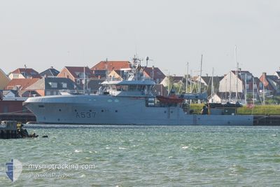
KNM MAGNUS LAGABOETE
Patrol Vessel
Current Trip
MILITARY OPERATIONS
| Time Travelled | 3 days |
|---|---|
| Remaining Time | --- |
| Distance Travelled | 41.27 nm |
| Remaining Distance | --- |
| AVG Speed | 5.8 Knots |
| MAX Speed | 12 Knots |
| AVG Wind | 7.3 knots |
| MAX Wind | 12.8 knots |
| MIN Temp | 4.3°C / 39.74°F |
| MAX Temp | 6.6°C / 43.88°F |
| Draught | 0 m |
| Position Received | 2 d ago |
Current Position
| Longitude | 5.23699° |
|---|---|
| Latitude | 60.33905° |
| Status | Under way using engine |
| Speed | |
| Course | 13° |
| Area | North Sea |
| Station | T-AIS |
| Position Received | 2 d ago |
Info
Information
The current position of KNM MAGNUS LAGABOETE is in North Sea with coordinates 60.33905° / 5.23699° as reported on 2024-04-17 11:00 by AIS to our vessel tracker app. The vessel's current speed is 0 Knots
The vessel KNM MAGNUS LAGABOETE (IMO: 9517472, MMSI: 258592000) is a Patrol Vessel that was built in 2011 ( 13 years old ). It's sailing under the flag of [NO] Norway.
In this page you can find informations about the vessels current position, last detected port calls, and current voyage information. If the vessels is not in coverage by AIS you will find the latest position.
The current position of KNM MAGNUS LAGABOETE is detected by our AIS receivers and we are not responsible for the reliability of the data. The last position was recorded while the vessel was in Coverage by the Ais receivers of our vessel tracking app.
Weather
| Temperature | 6.3°C / 43.34°F |
|---|---|
| Wind Speed | 9 knots |
| Direction | 316° NW |
| Pressure | 1010.1 hPa |
| Humidity | 73.3 % |
| Cloud Coverage | 35 % |
Featured Company
Last Port Calls
| Port | Arrival | Departure | Time In Port |
|---|---|---|---|
| 2024-04-12 10:00 | 2024-04-16 06:27 | 3 d | |
| 2024-03-16 07:10 | 2024-03-17 07:36 | 1 d | |
| 2024-03-15 03:48 | 2024-03-15 03:55 | 7 m | |
| 2024-03-11 19:43 | 2024-03-12 11:44 | 16 h | |
| 2024-03-04 12:18 | 2024-03-05 07:23 | 19 h | |
| 2024-03-03 11:50 | 2024-03-04 09:44 | 21 h | |
| 2024-02-27 21:36 | 2024-02-29 06:21 | 1 d | |
| 2024-02-15 19:00 | 2024-02-16 07:32 | 12 h | |
| 2024-02-14 10:52 | 2024-02-15 07:32 | 20 h | |
| 2024-02-13 16:03 | 2024-02-14 10:42 | 18 h |
Last Trips
| Origin | Departure | Destination | Arrival | Distance | |
|---|---|---|---|---|---|
| 2024-03-17 08:36 | 2024-04-12 12:00 | 583.34 nm | |||
| 2024-03-15 04:55 | 2024-03-16 08:10 | 232.49 nm | |||
| 2024-03-12 12:44 | 2024-03-15 04:48 | 527.43 nm | |||
| 2024-03-05 08:23 | 2024-03-11 20:43 | 69.00 nm | |||
| 2024-03-04 10:44 | 2024-03-04 13:18 | 15.70 nm | |||
| 2024-02-29 07:21 | 2024-03-03 12:50 | 929.55 nm | |||
| 2024-02-16 08:32 | 2024-02-27 22:36 | 233.78 nm | |||
| 2024-02-15 08:32 | 2024-02-15 20:00 | 134.49 nm | |||
| 2024-02-14 11:42 | 2024-02-14 11:52 | 1.48 nm | |||
| 2024-02-13 16:56 | 2024-02-13 17:03 | 0.46 nm |
Events
| Time | Event | Details | Position / Dest | Info |
|---|---|---|---|---|
| 2024-04-17 11:00 | OUT of Coverage |
60.33905 / 5.23699
North Sea
|
Speed: Course: 91.7° |
|
| 2024-04-17 10:53 | STOP Moving | 2.96 nm, South East of KNARREVIK |
60.33906 / 5.23696
MILITARY OPERATIONS
|
Speed: 0.2 kn Course: 10° |
| 2024-04-17 08:49 | START Moving | 3.18 nm, South East of KNARREVIK |
60.32393 / 5.20911
MILITARY OPERATIONS
|
Speed: 3.1 kn Course: 294° |
| 2024-04-17 08:31 | STOP Moving | 3.28 nm, South East of KNARREVIK |
60.32173 / 5.20732
MILITARY OPERATIONS
|
Speed: 0.3 kn Course: 0° |
| 2024-04-17 07:02 | START Moving | 3.55 nm, South East of KNARREVIK |
60.32534 / 5.23696
MILITARY OPERATIONS
|
Speed: 5.1 kn Course: 253.2° |
| 2024-04-17 06:51 | STOP Moving | 3.59 nm, South East of KNARREVIK |
60.32602 / 5.24053
MILITARY OPERATIONS
|
Speed: 0.3 kn Course: 300° |
| 2024-04-17 06:37 | START Moving | 3.07 nm, South East of KNARREVIK |
60.33719 / 5.23896
MILITARY OPERATIONS
|
Speed: 5.4 kn Course: 184.7° |
| 2024-04-17 06:23 | IN Coverage |
60.33906 / 5.23699
North Sea
|
Speed: Course: 106.7° |
|
| 2024-04-16 12:26 | Status Changed | Default Under way using engine |
60.33906 / 5.23699
MILITARY OPERATIONS
|
Speed: Course: 15° |
| 2024-04-16 12:26 | OUT of Coverage |
60.33906 / 5.23699
North Sea
|
Speed: Course: 196.8° |