
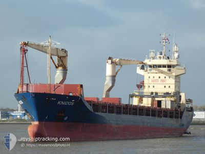
KNIDOS
General Cargo
Current Trip
| Time Travelled | 6 days |
|---|---|
| Remaining Time | 2 days |
| Distance Travelled | 1741.53 nm |
| Remaining Distance | 657.48 nm |
| AVG Speed | 11.7 Knots |
| MAX Speed | 13.9 Knots |
| AVG Wind | 10.8 knots |
| MAX Wind | 22 knots |
| MIN Temp | 26.6°C / 79.88°F |
| MAX Temp | 29.7°C / 85.46°F |
| Draught | 5.5 m |
| Position Received | 5 d ago |
Current Position
| Longitude | 39.54037° |
|---|---|
| Latitude | 18.42113° |
| Status | Under way using engine |
| Speed | 11.9 Knots |
| Course | 167.9° |
| Area | Red Sea |
| Station | T-AIS |
| Position Received | 5 d ago |
Info
Information
The current position of KNIDOS is in Red Sea with coordinates 18.42113° / 39.54037° as reported on 2024-04-18 07:09 by AIS to our vessel tracker app. The vessel's current speed is 11.9 Knots and is heading at the port of JEBEL ALI. The estimated time of arrival as calculated by MyShipTracking vessel tracking app is 2024-04-26 04:36 LT
The vessel KNIDOS (IMO: 9214173, MMSI: 372193000) is a General Cargo that was built in 2000 ( 24 years old ). It's sailing under the flag of [PA] Panama.
In this page you can find informations about the vessels current position, last detected port calls, and current voyage information. If the vessels is not in coverage by AIS you will find the latest position.
The current position of KNIDOS is detected by our AIS receivers and we are not responsible for the reliability of the data. The last position was recorded while the vessel was in Coverage by the Ais receivers of our vessel tracking app.
The current draught of KNIDOS as reported by AIS is 5.5 meters
Weather
| Temperature | 27.4°C / 81.32°F |
|---|---|
| Wind Speed | 14 knots |
| Direction | 187° S |
| Pressure | 1006.6 hPa |
| Humidity | 79.2 % |
| Cloud Coverage | --- |
Featured Company
Last Port Calls
| Port | Arrival | Departure | Time In Port |
|---|---|---|---|
| 2024-04-16 15:38 | 2024-04-17 15:59 | 1 d | |
| 2024-04-14 01:58 | 2024-04-14 10:45 | 8 h | |
| 2024-04-07 07:14 | 2024-04-08 20:17 | 1 d | |
| 2024-03-26 18:30 | 2024-03-29 03:17 | 2 d | |
| 2024-03-15 11:53 | 2024-03-17 09:17 | 1 d | |
| 2024-02-28 12:40 | 2024-03-09 01:09 | 9 d | |
| 2024-02-17 08:55 | 2024-02-20 04:35 | 2 d | |
| 2024-02-12 09:38 | 2024-02-15 05:47 | 2 d | |
| 2024-02-08 02:30 | 2024-02-10 14:46 | 2 d | |
| 2024-02-05 01:02 | 2024-02-05 08:26 | 7 h |
Last Trips
| Origin | Departure | Destination | Arrival | Distance | |
|---|---|---|---|---|---|
| 2024-04-08 22:17 | 2024-04-16 18:38 | 2146.33 nm | |||
| 2024-04-08 22:17 | 2024-04-14 03:58 | 1430.64 nm | |||
| 2024-03-29 06:17 | 2024-04-07 09:14 | 1318.93 nm | |||
| 2024-03-17 11:17 | 2024-03-26 21:30 | 1863.94 nm | |||
| 2024-03-09 02:09 | 2024-03-15 13:53 | 1777.79 nm | |||
| 2024-02-20 07:35 | 2024-02-28 13:40 | 1781.01 nm | |||
| 2024-02-15 07:47 | 2024-02-17 11:55 | 442.47 nm | |||
| 2024-02-10 17:46 | 2024-02-12 11:38 | 486.86 nm | |||
| 2024-02-05 11:26 | 2024-02-08 05:30 | 218.35 nm | |||
| 2024-01-22 08:26 | 2024-02-05 04:02 | 3487.35 nm |
Events
| Time | Event | Details | Position / Dest | Info |
|---|---|---|---|---|
| 2024-04-23 09:35 | START Moving |
17.07415 / 57.97336
AEJEA
|
Speed: 3.3 kn Course: 302° |
|
| 2024-04-23 06:45 | STOP Moving |
17.06234 / 57.97022
AEJEA
|
Speed: 0.2 kn Course: 260° |
|
| 2024-04-18 07:34 | Status Changed | Default Under way using engine |
18.33637 / 39.56342
AEJEA
|
Speed: 11.9 kn Course: 167.9° |
| 2024-04-18 07:09 | OUT of Coverage |
18.42113 / 39.54037
Red Sea
AEJEA
|
Speed: 11.9 kn Course: 167.9° |
|
| 2024-04-18 04:34 | Status Changed | Under way using engine Default |
18.92705 / 39.45220
AEJEA
|
Speed: 12.2 kn Course: 170° |
| 2024-04-18 04:19 | Status Changed | Default Under way using engine |
18.97441 / 39.44305
AEJEA
|
Speed: 12.1 kn Course: 169.5° |
| 2024-04-18 04:13 | Change Sea Area | Sudanese part of the Red Sea Saudi Arabian part of the Red Sea |
18.99629 / 39.43893
Red Sea
AEJEA
|
Speed: 12.1 kn Course: 169.5° |
| 2024-04-18 04:13 | Status Changed | Under way using engine Default |
18.99629 / 39.43893
AEJEA
|
Speed: 12.1 kn Course: 169° |
| 2024-04-18 03:56 | IN Coverage |
18.99629 / 39.43893
Red Sea
AEJEA
|
Speed: 12.1 kn Course: 169.5° |
|
| 2024-04-18 02:48 | OUT of Coverage |
19.27656 / 39.37795
Red Sea
AEJEA
|
Speed: 12 kn Course: 163.6° |