
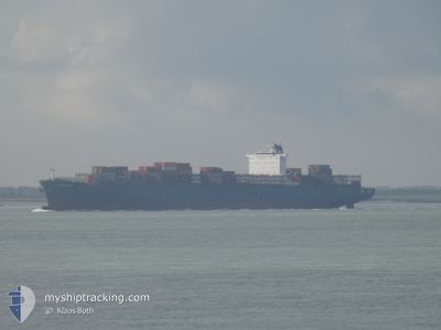
KALAHARI EXPRESS
Container Ship
Current Trip
| Time Travelled | 16 days |
|---|---|
| Remaining Time | 3 h, 4 mins |
| Distance Travelled | 6996.02 nm |
| Remaining Distance | 40.07 nm |
| AVG Speed | 17.3 Knots |
| MAX Speed | 23.2 Knots |
| AVG Wind | 13.6 knots |
| MAX Wind | 33 knots |
| MIN Temp | 6.8°C / 44.24°F |
| MAX Temp | 29.7°C / 85.46°F |
| Draught | 9 m |
| Position Received | 1 m ago |
Current Position
| Longitude | 3.19985° |
|---|---|
| Latitude | 51.87124° |
| Status | Under way using engine |
| Speed | 10.9 Knots |
| Course | 73.2° |
| Area | North Sea |
| Station | T-AIS |
| Position Received | 1 m ago |
Info
Information
The current position of KALAHARI EXPRESS is in North Sea with coordinates 51.87124° / 3.19985° as reported on 2024-04-25 00:09 by AIS to our vessel tracker app. The vessel's current speed is 10.9 Knots and is heading at the port of ROTTERDAM. The estimated time of arrival as calculated by MyShipTracking vessel tracking app is 2024-04-25 03:14 LT
The vessel KALAHARI EXPRESS (IMO: 9400095, MMSI: 636093117) is a Container Ship that was built in 2010 ( 14 years old ). It's sailing under the flag of [LR] Liberia.
In this page you can find informations about the vessels current position, last detected port calls, and current voyage information. If the vessels is not in coverage by AIS you will find the latest position.
The current position of KALAHARI EXPRESS is detected by our AIS receivers and we are not responsible for the reliability of the data. The last position was recorded while the vessel was in Coverage by the Ais receivers of our vessel tracking app.
The current draught of KALAHARI EXPRESS as reported by AIS is 9 meters
Weather
| Temperature | 7.7°C / 45.86°F |
|---|---|
| Wind Speed | 13 knots |
| Direction | 330° NNW |
| Pressure | 1009.8 hPa |
| Humidity | 62.5 % |
| Cloud Coverage | 94 % |
Featured Company
Last Port Calls
| Port | Arrival | Departure | Time In Port |
|---|---|---|---|
| 2024-04-03 13:44 | 2024-04-08 15:13 | 5 d | |
| 2024-03-25 06:00 | 2024-03-27 08:55 | 2 d | |
| 2024-03-05 17:45 | 2024-03-06 01:42 | 7 h | |
| 2024-03-04 16:46 | 2024-03-05 07:50 | 15 h | |
| 2024-02-27 04:24 | 2024-02-28 05:15 | 1 d | |
| 2024-02-25 09:57 | 2024-02-26 05:30 | 19 h | |
| 2024-02-23 07:19 | 2024-02-24 18:06 | 1 d | |
| 2024-02-04 08:43 | 2024-02-07 20:59 | 3 d |
Most Visited Ports (Last year)
| Port | Arrivals | |
|---|---|---|
| 10 | ||
| 6 | ||
| 5 | ||
| 5 | ||
| 5 | ||
| 4 |
Last Trips
| Origin | Departure | Destination | Arrival | Distance | |
|---|---|---|---|---|---|
| 2024-03-27 10:55 | 2024-04-03 15:44 | 665.58 nm | |||
| 2024-03-06 02:42 | 2024-03-25 08:00 | 5931.53 nm | |||
| 2024-03-05 08:50 | 2024-03-05 18:45 | 3.15 nm | |||
| 2024-02-28 06:15 | 2024-03-04 17:46 | 1745.50 nm | |||
| 2024-02-26 05:30 | 2024-02-27 05:24 | 355.45 nm | |||
| 2024-02-24 19:06 | 2024-02-25 09:57 | 156.80 nm | |||
| 2024-02-07 22:59 | 2024-02-23 08:19 | 6686.77 nm | |||
| 2024-01-31 19:52 | 2024-02-04 10:43 | 525.92 nm |
Events
| Time | Event | Details | Position / Dest | Info |
|---|---|---|---|---|
| 2024-04-24 22:35 | Change Sea Area | Dutch part of the North Sea Belgian part of the North Sea |
51.79131 / 2.69192
North Sea
NLRTM
|
Speed: 14.6 kn Course: 80.4° |
| 2024-04-24 20:44 | Change Sea Area | Belgian part of the North Sea French part of the North Sea |
51.50227 / 2.26878
North Sea
NLRTM
|
Speed: 12.4 kn Course: 40.8° |
| 2024-04-24 19:50 | Change Sea Area | French part of the North Sea United Kingdom part of the North Sea |
51.37779 / 2.06098
North Sea
NLRTM
|
Speed: 10.2 kn Course: 52.7° |
| 2024-04-24 19:12 | START Moving | 19.71 nm, East of RAMSGATE |
51.30205 / 1.94353
NLRTM
|
Speed: 10.2 kn Course: 40.4° |
| 2024-04-24 19:11 | STOP Moving | 19.65 nm, East of RAMSGATE |
51.30058 / 1.94157
NLRTM
|
Speed: Course: 0° |
| 2024-04-24 19:06 | START Moving | 19.16 nm, East of RAMSGATE |
51.28968 / 1.92696
NLRTM
|
Speed: 10.2 kn Course: 39.9° |
| 2024-04-24 19:06 | STOP Moving | 19.1 nm, East of RAMSGATE |
51.28827 / 1.92511
NLRTM
|
Speed: Course: 0° |
| 2024-04-24 18:44 | START Moving | 16.33 nm, North of CALAIS |
51.24062 / 1.86062
NLRTM
|
Speed: 10.2 kn Course: 41.2° |
| 2024-04-24 18:43 | STOP Moving | 16.24 nm, North of CALAIS |
51.23915 / 1.85862
NLRTM
|
Speed: Course: 0° |
| 2024-04-24 18:24 | START Moving | 13.96 nm, North of CALAIS |
51.19909 / 1.80049
NLRTM
|
Speed: 10.2 kn Course: 43.4° |