
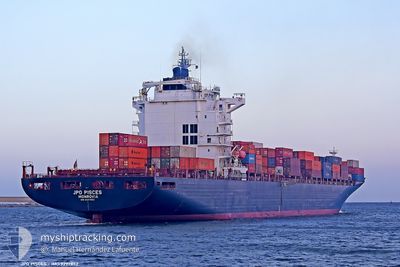
JPO PISCES
Container Ship
Current Trip
| Time Travelled | 5 days |
|---|---|
| Remaining Time | --- |
| Distance Travelled | 2219.69 nm |
| Remaining Distance | --- |
| AVG Speed | 15.8 Knots |
| MAX Speed | 18.9 Knots |
| AVG Wind | 13.3 knots |
| MAX Wind | 28.6 knots |
| MIN Temp | 2.8°C / 37.04°F |
| MAX Temp | 16.4°C / 61.52°F |
| Draught | 11.2 m |
| Position Received | 3 d ago |
Current Position
| Longitude | -8.72035° |
|---|---|
| Latitude | 49.47744° |
| Status | Under way using engine |
| Speed | 17 Knots |
| Course | 259.2° |
| Area | Celtic Sea |
| Station | T-AIS |
| Position Received | 3 d ago |
Info
Information
The current position of JPO PISCES is in Celtic Sea with coordinates 49.47744° / -8.72035° as reported on 2024-04-22 00:05 by AIS to our vessel tracker app. The vessel's current speed is 17 Knots and is heading at the port of CARTAGENA. The estimated time of arrival as calculated by MyShipTracking vessel tracking app is 2024-05-02 10:00 LT
The vessel JPO PISCES (IMO: 9297852, MMSI: 636090863) is a Container Ship that was built in 2005 ( 19 years old ). It's sailing under the flag of [LR] Liberia.
In this page you can find informations about the vessels current position, last detected port calls, and current voyage information. If the vessels is not in coverage by AIS you will find the latest position.
The current position of JPO PISCES is detected by our AIS receivers and we are not responsible for the reliability of the data. The last position was recorded while the vessel was in Coverage by the Ais receivers of our vessel tracking app.
The current draught of JPO PISCES as reported by AIS is 11.2 meters
Weather
| Temperature | 16°C / 60.8°F |
|---|---|
| Wind Speed | 5 knots |
| Direction | 161° SSE |
| Pressure | 1031.9 hPa |
| Humidity | 73.5 % |
| Cloud Coverage | 43 % |
Featured Company
Last Port Calls
| Port | Arrival | Departure | Time In Port |
|---|---|---|---|
| 2024-04-18 22:18 | 2024-04-19 20:50 | 22 h | |
| 2024-04-18 00:16 | 2024-04-18 12:04 | 11 h | |
| 2024-04-15 06:14 | 2024-04-17 07:27 | 2 d | |
| 2024-04-13 10:06 | 2024-04-14 03:31 | 17 h | |
| 2024-03-30 23:18 | 2024-04-01 03:18 | 1 d | |
| 2024-03-28 07:08 | 2024-03-29 09:31 | 1 d | |
| 2024-03-20 16:09 | 2024-03-22 05:27 | 1 d | |
| 2024-03-12 03:20 | 2024-03-13 02:57 | 23 h | |
| 2024-03-08 23:16 | 2024-03-09 12:37 | 13 h | |
| 2024-03-07 10:51 | 2024-03-07 20:19 | 9 h |
Most Visited Ports (Last year)
| Port | Arrivals | |
|---|---|---|
| 10 | ||
| 9 | ||
| 6 | ||
| 6 | ||
| 5 | ||
| 5 |
Last Trips
| Origin | Departure | Destination | Arrival | Distance | |
|---|---|---|---|---|---|
| 2024-04-18 14:04 | 2024-04-19 00:18 | 125.27 nm | |||
| 2024-04-17 09:27 | 2024-04-18 02:16 | 273.49 nm | |||
| 2024-04-14 05:31 | 2024-04-15 08:14 | 121.38 nm | |||
| 2024-03-31 22:18 | 2024-04-13 12:06 | 4815.30 nm | |||
| 2024-03-29 04:31 | 2024-03-30 18:18 | 56.47 nm | |||
| 2024-03-22 02:27 | 2024-03-28 02:08 | 2618.21 nm | |||
| 2024-03-12 21:57 | 2024-03-20 13:09 | 2621.16 nm | |||
| 2024-03-09 07:37 | 2024-03-11 22:20 | 75.26 nm | |||
| 2024-03-07 15:19 | 2024-03-08 18:16 | 281.02 nm | |||
| 2024-02-23 20:20 | 2024-03-07 05:51 | 4882.72 nm |
Events
| Time | Event | Details | Position / Dest | Info |
|---|---|---|---|---|
| 2024-04-22 00:10 | Status Changed | Default Under way using engine |
49.47167 / -8.75167
CARTAGENA
|
Speed: 17 kn Course: 259.2° |
| 2024-04-22 00:05 | Status Changed | Under way using engine Default |
49.47744 / -8.72035
CARTAGENA
|
Speed: 17 kn Course: 261° |
| 2024-04-22 00:05 | OUT of Coverage |
49.47744 / -8.72035
Celtic Sea
CARTAGENA
|
Speed: 17 kn Course: 259.2° |
|
| 2024-04-21 23:52 | Status Changed | Default Under way using engine |
49.48667 / -8.62167
CARTAGENA
|
Speed: 17.1 kn Course: 262° |
| 2024-04-21 20:25 | Change Sea Area | United Kingdom part of the Celtic Sea United Kingdom part of the English Channel |
49.65357 / -7.08778
Celtic Sea
CARTAGENA
|
Speed: 18 kn Course: 260.6° |
| 2024-04-21 20:23 | Status Changed | Under way using engine Default |
49.65576 / -7.06715
CARTAGENA
|
Speed: 17.9 kn Course: 260° |
| 2024-04-21 20:23 | IN Coverage |
49.65357 / -7.08778
Celtic Sea
CARTAGENA
|
Speed: 18 kn Course: 260.6° |
|
| 2024-04-21 16:11 | Status Changed | Default Under way using engine |
49.81918 / -5.24399
CARTAGENA
|
Speed: 16 kn Course: 255.9° |
| 2024-04-21 16:02 | OUT of Coverage |
49.82881 / -5.18543
English Channel
CARTAGENA
|
Speed: 16 kn Course: 255.9° |
|
| 2024-04-21 16:01 | Status Changed | Under way using engine Default |
49.83012 / -5.17757
CARTAGENA
|
Speed: 16.1 kn Course: 256° |