
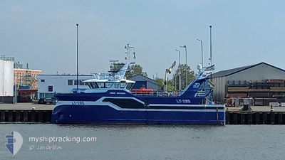
JONGE JOHANNES LT295
Fishing
Current Trip
VLISSINGEN
| Time Travelled | 3 days |
|---|---|
| Remaining Time | --- |
| Distance Travelled | 349.17 nm |
| Remaining Distance | --- |
| AVG Speed | 7.7 Knots |
| MAX Speed | 12.7 Knots |
| AVG Wind | 13.4 knots |
| MAX Wind | 21.3 knots |
| MIN Temp | 6.3°C / 43.34°F |
| MAX Temp | 9.4°C / 48.92°F |
| Draught | 0 m |
| Position Received | 1 h, 17 m ago |
Current Position
| Longitude | 1.95459° |
|---|---|
| Latitude | 51.38267° |
| Status | Under way sailing |
| Speed | 9.1 Knots |
| Course | 221° |
| Area | North Sea |
| Station | T-AIS |
| Position Received | 1 h, 17 m ago |
Info
Information
The current position of JONGE JOHANNES LT295 is in North Sea with coordinates 51.38267° / 1.95459° as reported on 2024-04-25 11:20 by AIS to our vessel tracker app. The vessel's current speed is 9.1 Knots
The vessel JONGE JOHANNES LT295 (IMO: 9848792, MMSI: 232026100) is a Fishing It's sailing under the flag of [GB] United Kingdom.
In this page you can find informations about the vessels current position, last detected port calls, and current voyage information. If the vessels is not in coverage by AIS you will find the latest position.
The current position of JONGE JOHANNES LT295 is detected by our AIS receivers and we are not responsible for the reliability of the data. The last position was recorded while the vessel was in Coverage by the Ais receivers of our vessel tracking app.
Weather
| Temperature | 8.8°C / 47.84°F |
|---|---|
| Wind Speed | 20 knots |
| Direction | 222° SW |
| Pressure | 1004 hPa |
| Humidity | 74.9 % |
| Cloud Coverage | 100 % |
Featured Company
Last Port Calls
| Port | Arrival | Departure | Time In Port |
|---|---|---|---|
| 2024-04-18 21:50 | 2024-04-22 00:26 | 3 d | |
| 2024-04-12 14:29 | 2024-04-15 00:31 | 2 d | |
| 2024-04-05 19:44 | 2024-04-08 00:28 | 2 d | |
| 2024-03-28 20:19 | 2024-04-01 15:15 | 3 d | |
| 2024-03-22 14:50 | 2024-03-25 01:31 | 2 d | |
| 2024-03-15 16:22 | 2024-03-18 01:34 | 2 d | |
| 2024-03-11 09:56 | 2024-03-11 13:43 | 3 h | |
| 2024-03-08 16:17 | 2024-03-11 01:33 | 2 d | |
| 2024-03-01 20:46 | 2024-03-04 02:19 | 2 d | |
| 2024-02-23 00:15 | 2024-02-26 01:31 | 3 d |
Most Visited Ports (Last year)
| Port | Arrivals | |
|---|---|---|
| 42 | ||
| 16 | ||
| 2 | ||
| 1 | ||
| 1 | ||
| 1 |
Last Trips
| Origin | Departure | Destination | Arrival | Distance | |
|---|---|---|---|---|---|
| 2024-04-15 02:31 | 2024-04-18 23:50 | 419.77 nm | |||
| 2024-04-08 02:28 | 2024-04-12 16:29 | 465.73 nm | |||
| 2024-04-01 17:15 | 2024-04-05 21:44 | 321.76 nm | |||
| 2024-03-25 02:31 | 2024-03-28 21:19 | 386.64 nm | |||
| 2024-03-18 02:34 | 2024-03-22 15:50 | 549.43 nm | |||
| 2024-03-11 13:43 | 2024-03-15 17:22 | 520.07 nm | |||
| 2024-03-11 02:33 | 2024-03-11 09:56 | 89.16 nm | |||
| 2024-03-04 03:19 | 2024-03-08 17:17 | 593.25 nm | |||
| 2024-02-26 02:31 | 2024-03-01 21:46 | 674.42 nm | |||
| 2024-02-19 01:32 | 2024-02-23 01:15 | 550.83 nm |
Events
| Time | Event | Details | Position / Dest | Info |
|---|---|---|---|---|
| 2024-04-25 11:20 | OUT of Coverage |
51.38267 / 1.95459
North Sea
|
Speed: 9.1 kn Course: 221° |
|
| 2024-04-25 11:16 | IN Coverage |
51.38267 / 1.95459
North Sea
|
Speed: 9.1 kn Course: 221° |
|
| 2024-04-25 09:10 | OUT of Coverage |
51.44644 / 2.03835
North Sea
|
Speed: 3.6 kn Course: 209° |
|
| 2024-04-25 09:10 | IN Coverage |
51.44644 / 2.03835
North Sea
|
Speed: 3.6 kn Course: 209° |
|
| 2024-04-25 07:11 | OUT of Coverage |
51.47525 / 2.09258
North Sea
|
Speed: 1 kn Course: 192° |
|
| 2024-04-25 06:24 | STOP Moving |
51.48218 / 2.09398
VLISSINGEN
|
Speed: 0.2 kn Course: 207° |
|
| 2024-04-25 06:23 | Change Sea Area | United Kingdom part of the North Sea French part of the North Sea |
51.48227 / 2.09417
North Sea
|
Speed: 0.7 kn Course: 222° |
| 2024-04-25 06:14 | Change Sea Area | French part of the North Sea United Kingdom part of the North Sea |
51.48636 / 2.11354
North Sea
|
Speed: 8.7 kn Course: 196° |
| 2024-04-25 06:13 | Change Sea Area | United Kingdom part of the North Sea French part of the North Sea |
51.49020 / 2.11446
North Sea
|
Speed: 9 kn Course: 202° |
| 2024-04-25 06:07 | Change Sea Area | French part of the North Sea United Kingdom part of the English Channel |
51.50052 / 2.12382
North Sea
|
Speed: 8.8 kn Course: 201° |