
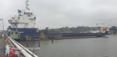
JOHN DUIGAN
Cargo
Current Trip
| Trip Time | 14 h, 32 mins |
|---|---|
| Trip Distance | 127.07 nm |
| AVG Speed | 8.9 Knots |
| MAX Speed | 10.2 Knots |
| Draught | 3.4 m |
| AVG Wind | 7.5 knots |
| MAX Wind | 14 knots |
| MIN Temp | 8.6°C / 47.48°F |
| MAX Temp | 14.8°C / 58.64°F |
| Position Received | 2 m ago |
Current Position
| Longitude | 146.36500° |
|---|---|
| Latitude | -41.18843° |
| Status | Moored |
| Speed | |
| Course | 159° |
| Area | Bass Strait |
| Station | T-AIS |
| Position Received | 2 m ago |
Info
Information
The current position of JOHN DUIGAN is in Bass Strait with coordinates -41.18843° / 146.36500° as reported on 2024-04-18 23:45 by AIS to our vessel tracker app. The vessel's current speed is 0 Knots and is currently inside the port of DEVONPORT.
The vessel JOHN DUIGAN (IMO: 9717606, MMSI: 503064840) is a Cargo It's sailing under the flag of [AU] Australia.
In this page you can find informations about the vessels current position, last detected port calls, and current voyage information. If the vessels is not in coverage by AIS you will find the latest position.
The current position of JOHN DUIGAN is detected by our AIS receivers and we are not responsible for the reliability of the data. The last position was recorded while the vessel was in Coverage by the Ais receivers of our vessel tracking app.
The current draught of JOHN DUIGAN as reported by AIS is 3.4 meters
Weather
| Temperature | 12.2°C / 53.96°F |
|---|---|
| Wind Speed | 3 knots |
| Direction | 190° S |
| Pressure | 1022.4 hPa |
| Humidity | 53.1 % |
| Cloud Coverage | --- |
Featured Company
Last Port Calls
| Port | Arrival | Departure | Time In Port |
|---|---|---|---|
| 2024-04-16 20:22 | |||
| 2024-04-15 21:49 | 2024-04-16 05:50 | 8 h | |
| 2024-04-14 20:19 | 2024-04-15 06:56 | 10 h | |
| 2024-04-13 21:58 | 2024-04-14 04:46 | 6 h | |
| 2024-04-09 20:31 | 2024-04-13 05:12 | 3 d | |
| 2024-04-08 21:48 | 2024-04-09 06:54 | 9 h | |
| 2024-04-07 21:08 | 2024-04-08 06:49 | 9 h | |
| 2024-04-06 20:49 | |||
| 2024-04-02 19:13 | 2024-04-06 04:23 | 3 d | |
| 2024-04-01 19:54 | 2024-04-02 04:16 | 8 h |
Most Visited Ports (Last year)
| Port | Arrivals | |
|---|---|---|
| 72 | ||
| 26 |
Last Trips
| Origin | Departure | Destination | Arrival | Distance | |
|---|---|---|---|---|---|
| 2024-04-16 15:50 | 2024-04-17 06:22 | 127.07 nm | |||
| 2024-04-15 16:56 | 2024-04-16 07:49 | 127.33 nm | |||
| 2024-04-14 14:46 | 2024-04-15 06:19 | 126.65 nm | |||
| 2024-04-13 15:12 | 2024-04-14 07:58 | 134.61 nm | |||
| 2024-04-09 16:54 | 2024-04-10 06:31 | 132.32 nm | |||
| 2024-04-08 16:49 | 2024-04-09 07:48 | 128.46 nm | |||
| 2024-04-06 15:23 | 2024-04-07 06:49 | 129.05 nm | |||
| 2024-04-02 15:16 | 2024-04-03 06:13 | 132.29 nm | |||
| 2024-04-01 16:18 | 2024-04-02 06:54 | 128.17 nm | |||
| 2024-03-31 13:05 | 2024-04-01 06:03 | 120.96 nm |
Events
| Time | Event | Details | Position / Dest | Info |
|---|---|---|---|---|
| 2024-04-16 21:09 | Status Changed | Moored Under way using engine |
-41.18841 / 146.36503
[AU] DEVONPORT
|
Speed: Course: 158° |
| 2024-04-16 20:37 | STOP Moving |
-41.18838 / 146.36498
[AU] DEVONPORT
|
Speed: 0.3 kn Course: 159° |
|
| 2024-04-16 20:22 | PORT ARRIVAL |
|
-41.17007 / 146.36673
[AU] DEVONPORT
|
Speed: 9.3 kn Course: 204.1° |
| 2024-04-16 12:10 | IN Coverage |
-40.56191 / 145.03812
Bass Strait
|
Speed: 9.5 kn Course: 121.8° |
|
| 2024-04-16 08:26 | OUT of Coverage |
-40.26346 / 144.51374
Bass Strait
|
Speed: 9.1 kn Course: 118.2° |
|
| 2024-04-16 06:41 | Detected in Sea | Australian part of the Bass Strait |
-40.14231 / 144.19460
Bass Strait
|
Speed: 9.4 kn Course: 120.6° |
| 2024-04-16 05:50 | START Moving | 0.25 nm, South West of KING ISLAND |
-40.06996 / 144.05559
DEVONPORT
|
Speed: 7.8 kn Course: 196° |
| 2024-04-16 05:50 | PORT DEPARTURE |
|
-40.06996 / 144.05559
DEVONPORT
|
Speed: 2.3 kn Course: 244° |
| 2024-04-16 05:31 | Status Changed | Under way using engine Moored |
-40.06592 / 144.06105
[AU] KING ISLAND
|
Speed: Course: 337° |
| 2024-04-15 23:50 | IN Coverage |
-40.06596 / 144.06104
Great Australian Bight
[AU] KING ISLAND
|
Speed: Course: 259.4° |