
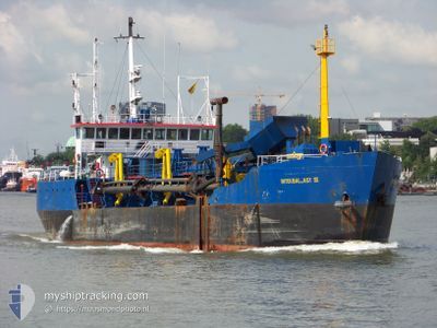
INTERBALLAST III
Hopper Dredger
Current Trip
| Trip Time | 4 days |
|---|---|
| Trip Distance | 443.82 nm |
| AVG Speed | 7.7 Knots |
| MAX Speed | 11.4 Knots |
| Draught | 3.8 m |
| AVG Wind | 17 knots |
| MAX Wind | 28.8 knots |
| MIN Temp | 4.1°C / 39.38°F |
| MAX Temp | 10.9°C / 51.62°F |
| Position Received | Now |
Current Position
| Longitude | 3.59279° |
|---|---|
| Latitude | 51.44723° |
| Status | Under way using engine |
| Speed | 0.1 Knots |
| Course | 181° |
| Area | North Sea |
| Station | T-AIS |
| Position Received | Now |
Info
Information
The current position of INTERBALLAST III is in North Sea with coordinates 51.44723° / 3.59279° as reported on 2024-04-19 19:49 by AIS to our vessel tracker app. The vessel's current speed is 0.1 Knots and is currently inside the port of VLISSINGEN STATION.
The vessel INTERBALLAST III (IMO: 8113463, MMSI: 244269000) is a Hopper Dredger that was built in 1981 ( 43 years old ). It's sailing under the flag of [NL] Netherlands.
In this page you can find informations about the vessels current position, last detected port calls, and current voyage information. If the vessels is not in coverage by AIS you will find the latest position.
The current position of INTERBALLAST III is detected by our AIS receivers and we are not responsible for the reliability of the data. The last position was recorded while the vessel was in Coverage by the Ais receivers of our vessel tracking app.
The current draught of INTERBALLAST III as reported by AIS is 3.8 meters
Weather
| Temperature | 8.1°C / 46.58°F |
|---|---|
| Wind Speed | 28 knots |
| Direction | 340° NNW |
| Pressure | 1016.9 hPa |
| Humidity | 65.1 % |
| Cloud Coverage | 35 % |
Featured Company
Last Port Calls
| Port | Arrival | Departure | Time In Port |
|---|---|---|---|
| 2024-04-19 16:53 | |||
| 2024-04-13 00:23 | 2024-04-14 20:45 | 1 d | |
| 2024-04-06 08:01 | 2024-04-07 17:11 | 1 d | |
| 2024-03-30 12:57 | 2024-04-01 19:48 | 2 d | |
| 2024-03-23 17:24 | 2024-03-24 20:36 | 1 d | |
| 2024-03-16 08:23 | 2024-03-17 22:00 | 1 d | |
| 2024-03-09 08:40 | 2024-03-11 05:43 | 1 d | |
| 2024-03-05 22:23 | 2024-03-07 16:04 | 1 d | |
| 2024-03-05 13:45 | 2024-03-05 18:23 | 4 h | |
| 2024-03-04 06:41 | 2024-03-05 08:37 | 1 d |
Most Visited Ports (Last year)
| Port | Arrivals | |
|---|---|---|
| 29 | ||
| 6 | ||
| 1 |
Last Trips
| Origin | Departure | Destination | Arrival | Distance | |
|---|---|---|---|---|---|
| 2024-04-14 22:45 | 2024-04-19 18:53 | 443.82 nm | |||
| 2024-04-07 19:11 | 2024-04-13 02:23 | 498.51 nm | |||
| 2024-04-01 21:48 | 2024-04-06 10:01 | 456.94 nm | |||
| 2024-03-24 21:36 | 2024-03-30 13:57 | 769.80 nm | |||
| 2024-03-17 23:00 | 2024-03-23 18:24 | 746.41 nm | |||
| 2024-03-11 06:43 | 2024-03-16 09:23 | 397.12 nm | |||
| 2024-03-07 17:04 | 2024-03-09 09:40 | 104.29 nm | |||
| 2024-03-05 19:23 | 2024-03-05 23:23 | 32.60 nm | |||
| 2024-03-05 09:37 | 2024-03-05 14:45 | 11.07 nm | |||
| 2024-03-04 03:17 | 2024-03-04 07:41 | 34.33 nm |
Events
| Time | Event | Details | Position / Dest | Info |
|---|---|---|---|---|
| 2024-04-19 16:53 | PORT ARRIVAL |
|
51.44501 / 3.59223
[NL] VLISSINGEN STATION
|
Speed: 1.3 kn Course: 3° |
| 2024-04-19 16:34 | STOP Moving | 0.35 nm, South East of VLISSINGEN STATION |
51.44267 / 3.59574
DREDGE-HOOFDPLAAT
|
Speed: 0.2 kn Course: 291° |
| 2024-04-19 15:35 | START Moving | 2.4 nm, East of BRESKENS |
51.38700 / 3.62878
DREDGE-HOOFDPLAAT
|
Speed: 4.9 kn Course: 268° |
| 2024-04-19 04:38 | STOP Moving | 2.5 nm, East of BRESKENS |
51.38785 / 3.63191
DREDGE-HOOFDPLAAT
|
Speed: 0.3 kn Course: 14° |
| 2024-04-18 21:32 | START Moving | 1.76 nm, South East of BRESKENS |
51.38638 / 3.61037
DREDGE-HOOFDPLAAT
|
Speed: 5.1 kn Course: 291.4° |
| 2024-04-18 18:42 | STOP Moving | 1.87 nm, South East of BRESKENS |
51.38574 / 3.61309
DREDGE-HOOFDPLAAT
|
Speed: 0.3 kn Course: 291° |
| 2024-04-18 17:17 | Change Sea Area | Dutch part of the North Sea Belgian part of the North Sea |
51.41394 / 3.33076
North Sea
|
Speed: 7.9 kn Course: 90.5° |
| 2024-04-18 11:53 | Change Sea Area | Belgian part of the North Sea Dutch part of the North Sea |
51.41516 / 3.31497
North Sea
|
Speed: 9.4 kn Course: 275.7° |
| 2024-04-18 10:40 | START Moving | 2.42 nm, East of BRESKENS |
51.38655 / 3.62903
DREDGE-HOOFDPLAAT
|
Speed: 6.9 kn Course: 279.6° |
| 2024-04-18 09:48 | STOP Moving | 2.55 nm, East of BRESKENS |
51.38642 / 3.63258
DREDGE-HOOFDPLAAT
|
Speed: 0.2 kn Course: 73° |