
INCEPTION
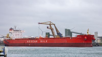
Bulk Carrier
Current Trip
ORDERS
| Time Travelled | 29 days |
|---|---|
| Remaining Time | --- |
| Distance Travelled | 6178.43 nm |
| Remaining Distance | --- |
| AVG Speed | 8.9 Knots |
| MAX Speed | 15.1 Knots |
| AVG Wind | 11.7 knots |
| MAX Wind | 30 knots |
| MIN Temp | 19.2°C / 66.56°F |
| MAX Temp | 30.3°C / 86.54°F |
| Draught | 8.5 m |
| Position Received | 8 d ago |
Current Position
| Longitude | 54.47677° |
|---|---|
| Latitude | -21.03550° |
| Status | Under way using engine |
| Speed | 10.1 Knots |
| Course | 238° |
| Area | Indian Ocean |
| Station | T-AIS |
| Position Received | 8 d ago |
Info
Information
The current position of INCEPTION is in Indian Ocean with coordinates -21.03550° / 54.47677° as reported on 2024-04-09 03:38 by AIS to our vessel tracker app. The vessel's current speed is 10.1 Knots
The vessel INCEPTION (IMO: 9540481, MMSI: 636015353) is a Bulk Carrier that was built in 2011 ( 13 years old ). It's sailing under the flag of [LR] Liberia.
In this page you can find informations about the vessels current position, last detected port calls, and current voyage information. If the vessels is not in coverage by AIS you will find the latest position.
The current position of INCEPTION is detected by our AIS receivers and we are not responsible for the reliability of the data. The last position was recorded while the vessel was in Coverage by the Ais receivers of our vessel tracking app.
The current draught of INCEPTION as reported by AIS is 8.5 meters
Weather
| Temperature | 19.4°C / 66.92°F |
|---|---|
| Wind Speed | 12 knots |
| Direction | 222° SW |
| Pressure | 1013.6 hPa |
| Humidity | 86.2 % |
| Cloud Coverage | --- |
Featured Company
Most Visited Ports (Last year)
| Port | Arrivals | |
|---|---|---|
| 2 | ||
| 2 | ||
| 1 | ||
| 1 | ||
| 1 | ||
| 1 |
Last Trips
| Origin | Departure | Destination | Arrival | Distance | |
|---|---|---|---|---|---|
| 2024-01-27 03:34 | 2024-03-16 14:37 | 8126.69 nm |
Events
| Time | Event | Details | Position / Dest | Info |
|---|---|---|---|---|
| 2024-04-09 03:43 | Status Changed | Default Under way using engine |
-21.04180 / 54.46540
ORDERS
|
Speed: 10.1 kn Course: 238° |
| 2024-04-09 03:38 | Status Changed | Under way using engine Default |
-21.03550 / 54.47677
ORDERS
|
Speed: 10.2 kn Course: 239° |
| 2024-04-09 03:38 | OUT of Coverage |
-21.03550 / 54.47677
Indian Ocean
ORDERS
|
Speed: 10.1 kn Course: 238° |
|
| 2024-04-09 03:32 | Status Changed | Default Under way using engine |
-21.02635 / 54.49323
ORDERS
|
Speed: 10.3 kn Course: 239° |
| 2024-04-09 03:25 | Status Changed | Under way using engine Default |
-21.01633 / 54.51128
ORDERS
|
Speed: 10.2 kn Course: 237° |
| 2024-04-09 03:17 | Status Changed | Default Under way using engine |
-21.00355 / 54.53197
ORDERS
|
Speed: 10 kn Course: 235° |
| 2024-04-09 03:05 | Status Changed | Under way using engine Default |
-20.98490 / 54.56037
ORDERS
|
Speed: 10 kn Course: 233° |
| 2024-04-09 02:56 | Status Changed | Default Under way using engine |
-20.96865 / 54.58400
ORDERS
|
Speed: 10.2 kn Course: 234° |
| 2024-04-09 02:49 | Status Changed | Under way using engine Default |
-20.95792 / 54.59977
ORDERS
|
Speed: 10 kn Course: 234° |
| 2024-04-09 02:47 | Status Changed | Default Under way using engine |
-20.95437 / 54.60503
ORDERS
|
Speed: 10.1 kn Course: 234° |