
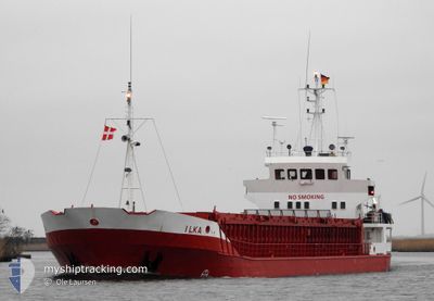
ILKA
General Cargo
Current Trip
| Time Travelled | 9 h, 14 mins |
|---|---|
| Remaining Time | --- |
| Distance Travelled | 58.22 nm |
| Remaining Distance | --- |
| AVG Speed | 7 Knots |
| MAX Speed | 8 Knots |
| AVG Wind | 17.3 knots |
| MAX Wind | 21.2 knots |
| MIN Temp | 4.6°C / 40.28°F |
| MAX Temp | 6.1°C / 42.98°F |
| Draught | 4.1 m |
| Position Received | Now |
Current Position
| Longitude | 7.71966° |
|---|---|
| Latitude | 57.90677° |
| Status | Under way using engine |
| Speed | 6.9 Knots |
| Course | 90.2° |
| Area | Skaggerak |
| Station | T-AIS |
| Position Received | Now |
Info
Information
The current position of ILKA is in Skaggerak with coordinates 57.90677° / 7.71966° as reported on 2024-04-19 17:23 by AIS to our vessel tracker app. The vessel's current speed is 6.9 Knots and is heading at the port of BURGSTAAKEN. The estimated time of arrival as calculated by MyShipTracking vessel tracking app is 2024-04-21 10:00 LT
The vessel ILKA (IMO: 8504947, MMSI: 218179000) is a General Cargo that was built in 1985 ( 39 years old ). It's sailing under the flag of [DE] Germany.
In this page you can find informations about the vessels current position, last detected port calls, and current voyage information. If the vessels is not in coverage by AIS you will find the latest position.
The current position of ILKA is detected by our AIS receivers and we are not responsible for the reliability of the data. The last position was recorded while the vessel was in Coverage by the Ais receivers of our vessel tracking app.
The current draught of ILKA as reported by AIS is 4.1 meters
Weather
| Temperature | 4.6°C / 40.28°F |
|---|---|
| Wind Speed | 12 knots |
| Direction | 85° E |
| Pressure | 1010.1 hPa |
| Humidity | 62.6 % |
| Cloud Coverage | 58 % |
Featured Company
Last Port Calls
| Port | Arrival | Departure | Time In Port |
|---|---|---|---|
| 2024-04-18 17:39 | 2024-04-19 08:10 | 14 h | |
| 2024-04-16 21:01 | 2024-04-17 14:42 | 17 h | |
| 2024-04-16 15:55 | 2024-04-16 16:14 | 18 m | |
| 2024-04-13 07:58 | 2024-04-15 14:49 | 2 d | |
| 2024-04-12 05:34 | 2024-04-12 18:40 | 13 h | |
| 2024-04-11 02:59 | 2024-04-11 12:31 | 9 h | |
| 2024-04-10 23:37 | 2024-04-11 00:03 | 25 m | |
| 2024-04-08 22:17 | 2024-04-10 11:47 | 1 d | |
| 2024-04-04 16:15 | 2024-04-05 15:55 | 23 h | |
| 2024-03-28 09:45 | 2024-04-03 16:01 | 6 d |
Last Trips
| Origin | Departure | Destination | Arrival | Distance | |
|---|---|---|---|---|---|
| 2024-04-17 16:42 | 2024-04-18 19:39 | 169.74 nm | |||
| 2024-04-16 18:14 | 2024-04-16 23:01 | 41.85 nm | |||
| 2024-04-15 16:49 | 2024-04-16 17:55 | 234.43 nm | |||
| 2024-04-12 20:40 | 2024-04-13 09:58 | 108.43 nm | |||
| 2024-04-11 14:31 | 2024-04-12 07:34 | 121.12 nm | |||
| 2024-04-11 02:03 | 2024-04-11 04:59 | 14.89 nm | |||
| 2024-04-10 13:47 | 2024-04-11 01:37 | 99.84 nm | |||
| 2024-04-05 18:55 | 2024-04-09 00:17 | 529.37 nm | |||
| 2024-04-03 18:01 | 2024-04-04 19:15 | 197.48 nm | |||
| 2024-03-25 21:09 | 2024-03-28 10:45 | 427.27 nm |
Events
| Time | Event | Details | Position / Dest | Info |
|---|---|---|---|---|
| 2024-04-19 14:24 | Change Sea Area | Norwegian part of the Skaggerak Norwegian part of the North Sea |
57.92289 / 7.13153
Skaggerak
DEBSK
|
Speed: 7 kn Course: 87.8° |
| 2024-04-19 08:10 | PORT DEPARTURE |
|
58.32459 / 6.25890
DEBSK
|
Speed: 5.6 kn Course: 164° |
| 2024-04-19 08:08 | START Moving |
58.32680 / 6.25830
[NO] REKEFJORD
|
Speed: 3.7 kn Course: 177° |
|
| 2024-04-19 08:02 | Status Changed | Under way using engine Moored |
58.32791 / 6.26089
[NO] REKEFJORD
|
Speed: Course: 242° |
| 2024-04-19 06:59 | ETA Changed | 2024/04/21 10:00 2024/04/21 08:00 |
58.32788 / 6.26086
[NO] REKEFJORD
|
Speed: Course: 242° |
| 2024-04-18 18:08 | Draught Changed | 4.1 2.6 |
58.32796 / 6.26107
[NO] REKEFJORD
|
Speed: Course: 243° |
| 2024-04-18 18:08 | Destination Changed | DEBSK NOREK |
58.32796 / 6.26107
[NO] REKEFJORD
|
Speed: Course: 243° |
| 2024-04-18 18:08 | ETA Changed | 2024/04/21 08:00 2024/04/18 18:00 |
58.32796 / 6.26107
[NO] REKEFJORD
|
Speed: Course: 243° |
| 2024-04-18 17:59 | Status Changed | Moored Under way using engine |
58.32794 / 6.26103
[NO] REKEFJORD
|
Speed: Course: 243° |
| 2024-04-18 17:50 | STOP Moving |
58.32807 / 6.26080
[NO] REKEFJORD
|
Speed: 0.1 kn Course: 230° |