
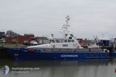
HELGOLAND
Law Enforcement
Current Position
| Longitude | 8.86468° |
|---|---|
| Latitude | 54.12855° |
| Status | Moored |
| Speed | |
| Course | 54° |
| Area | North Sea |
| Station | T-AIS |
| Position Received | 17 m ago |
Info
Information
The current position of HELGOLAND is in North Sea with coordinates 54.12855° / 8.86468° as reported on 2024-04-18 07:24 by AIS to our vessel tracker app. The vessel's current speed is 0 Knots and is currently inside the port of BUESUM.
The vessel HELGOLAND (MMSI: 211634540) is a Law Enforcement It's sailing under the flag of [DE] Germany.
In this page you can find informations about the vessels current position, last detected port calls, and current voyage information. If the vessels is not in coverage by AIS you will find the latest position.
The current position of HELGOLAND is detected by our AIS receivers and we are not responsible for the reliability of the data. The last position was recorded while the vessel was in Coverage by the Ais receivers of our vessel tracking app.
Weather
| Temperature | 7.7°C / 45.86°F |
|---|---|
| Wind Speed | 4 knots |
| Direction | 288° WNW |
| Pressure | 1015.8 hPa |
| Humidity | 74.2 % |
| Cloud Coverage | 6 % |
Featured Company
Last Port Calls
| Port | Arrival | Departure | Time In Port |
|---|---|---|---|
| 2024-03-15 10:01 | 2024-03-15 12:02 | 2 h | |
| 2024-03-14 13:54 | 2024-03-15 09:27 | 19 h | |
| 2024-03-14 10:47 | 2024-03-14 13:07 | 2 h | |
| 2024-03-14 08:59 | |||
| 2024-03-10 09:42 | 2024-03-10 13:43 | 4 h | |
| 2024-03-10 08:50 | |||
| 2024-02-27 14:32 | 2024-02-28 07:40 | 17 h | |
| 2024-02-27 14:01 | 2024-02-27 14:10 | 8 m | |
| 2024-02-27 09:13 | |||
| 2024-02-11 14:59 | 2024-02-12 07:47 | 16 h |
Last Trips
| Origin | Departure | Destination | Arrival | Distance | |
|---|---|---|---|---|---|
| 2024-03-15 10:27 | 2024-03-15 11:01 | 8.25 nm | |||
| 2024-03-14 14:07 | 2024-03-14 14:54 | 8.66 nm | |||
| 2024-03-14 09:59 | 2024-03-14 11:47 | 16.18 nm | |||
| 2024-03-10 09:50 | 2024-03-10 10:42 | 5.74 nm | |||
| 2024-02-27 15:10 | 2024-02-27 15:32 | 5.80 nm | |||
| 2024-02-27 10:13 | 2024-02-27 15:01 | 48.73 nm | |||
| 2024-02-11 13:07 | 2024-02-11 15:59 | 30.84 nm | |||
| 2024-02-11 10:10 | 2024-02-11 11:01 | 7.13 nm |
Events
| Time | Event | Details | Position / Dest | Info |
|---|---|---|---|---|
| 2024-04-17 22:21 | IN Coverage |
54.12855 / 8.86469
North Sea
[DE] BUESUM
|
Speed: Course: 307° |
|
| 2024-04-17 18:51 | OUT of Coverage |
54.12858 / 8.86469
North Sea
[DE] BUESUM
|
Speed: Course: 349° |
|
| 2024-04-17 18:12 | IN Coverage |
54.12857 / 8.86473
North Sea
[DE] BUESUM
|
Speed: 0.1 kn Course: 8° |
|
| 2024-04-17 17:00 | OUT of Coverage |
54.12857 / 8.86472
North Sea
[DE] BUESUM
|
Speed: Course: 332° |
|
| 2024-04-17 13:36 | IN Coverage |
54.12855 / 8.86471
North Sea
[DE] BUESUM
|
Speed: Course: 56° |
|
| 2024-04-17 10:12 | OUT of Coverage |
54.12857 / 8.86468
North Sea
[DE] BUESUM
|
Speed: Course: 330° |
|
| 2024-04-17 09:24 | IN Coverage |
54.12854 / 8.86470
North Sea
[DE] BUESUM
|
Speed: Course: 330° |
|
| 2024-04-17 07:54 | OUT of Coverage |
54.12855 / 8.86471
North Sea
[DE] BUESUM
|
Speed: Course: 358° |
|
| 2024-04-17 01:15 | IN Coverage |
54.12854 / 8.86467
North Sea
[DE] BUESUM
|
Speed: Course: 347° |
|
| 2024-04-16 23:48 | OUT of Coverage |
54.12856 / 8.86468
North Sea
[DE] BUESUM
|
Speed: Course: 247° |