
HE YANG
Container Ship
Current Trip
KAN KR
| Time Travelled | 5 days |
|---|---|
| Remaining Time | --- |
| Distance Travelled | 1111.81 nm |
| Remaining Distance | --- |
| AVG Speed | 11.4 Knots |
| MAX Speed | 16.5 Knots |
| AVG Wind | 10.1 knots |
| MAX Wind | 33.7 knots |
| MIN Temp | 10.4°C / 50.72°F |
| MAX Temp | 23.1°C / 73.58°F |
| Draught | 7.9 m |
| Position Received | 5 d ago |
Current Position
| Longitude | 128.59615° |
|---|---|
| Latitude | 34.53730° |
| Status | Under way using engine |
| Speed | 16.1 Knots |
| Course | 237.7° |
| Area | Japan Sea |
| Station | T-AIS |
| Position Received | 5 d ago |
Info
Information
The current position of HE YANG is in Japan Sea with coordinates 34.53730° / 128.59615° as reported on 2024-04-14 16:27 by AIS to our vessel tracker app. The vessel's current speed is 16.1 Knots
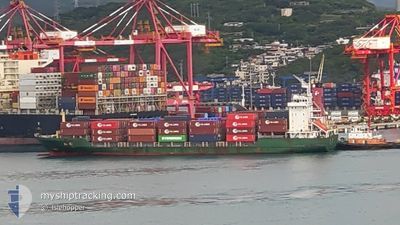
The vessel HE YANG (IMO: 9179476, MMSI: 413453290) is a Container Ship that was built in 2000 ( 24 years old ). It's sailing under the flag of [CN] China.
In this page you can find informations about the vessels current position, last detected port calls, and current voyage information. If the vessels is not in coverage by AIS you will find the latest position.
The current position of HE YANG is detected by our AIS receivers and we are not responsible for the reliability of the data. The last position was recorded while the vessel was in Coverage by the Ais receivers of our vessel tracking app.
The current draught of HE YANG as reported by AIS is 7.9 meters
Weather
| Temperature | 15.4°C / 59.72°F |
|---|---|
| Wind Speed | 11 knots |
| Direction | 265° W |
| Pressure | 1007.3 hPa |
| Humidity | 93.7 % |
| Cloud Coverage | 100 % |
Featured Company
Last Port Calls
| Port | Arrival | Departure | Time In Port |
|---|---|---|---|
| 2024-04-14 21:32 | 2024-04-15 02:46 | 5 h | |
| 2024-04-13 19:40 | 2024-04-14 13:31 | 17 h | |
| 2024-04-08 07:52 | 2024-04-08 12:33 | 4 h | |
| 2024-04-07 00:39 | 2024-04-08 00:22 | 23 h | |
| 2024-03-30 14:23 | 2024-03-30 21:57 | 7 h | |
| 2024-03-29 15:53 | 2024-03-30 06:17 | 14 h | |
| 2024-03-21 00:34 | 2024-03-21 04:22 | 3 h | |
| 2024-03-19 19:59 | 2024-03-20 14:30 | 18 h | |
| 2024-03-13 12:19 | 2024-03-13 15:51 | 3 h | |
| 2024-03-12 08:13 | 2024-03-13 03:08 | 18 h |
Last Trips
| Origin | Departure | Destination | Arrival | Distance | |
|---|---|---|---|---|---|
| 2024-04-14 22:31 | 2024-04-15 06:32 | 98.36 nm | |||
| 2024-04-08 21:33 | 2024-04-14 04:40 | 1271.60 nm | |||
| 2024-04-08 09:22 | 2024-04-08 16:52 | 98.85 nm | |||
| 2024-03-31 06:57 | 2024-04-07 09:39 | 1300.43 nm | |||
| 2024-03-30 15:17 | 2024-03-30 23:23 | 100.11 nm | |||
| 2024-03-21 13:22 | 2024-03-30 00:53 | 1339.90 nm | |||
| 2024-03-20 23:30 | 2024-03-21 09:34 | 105.54 nm | |||
| 2024-03-14 00:51 | 2024-03-20 04:59 | 1124.10 nm | |||
| 2024-03-13 12:08 | 2024-03-13 21:19 | 102.75 nm | |||
| 2024-03-05 06:19 | 2024-03-12 17:13 | 1206.34 nm |
Events
| Time | Event | Details | Position / Dest | Info |
|---|---|---|---|---|
| 2024-04-17 07:03 | STOP Moving | 5.55 nm, South West of YIZHENG |
32.20821 / 119.05883
KAN KR
|
Speed: Course: 222° |
| 2024-04-16 05:04 | START Moving |
31.20670 / 123.12495
KAN KR
|
Speed: 6.7 kn Course: 221° |
|
| 2024-04-16 04:12 | STOP Moving |
31.20167 / 123.13500
KAN KR
|
Speed: Course: -1° |
|
| 2024-04-15 02:46 | PORT DEPARTURE |
|
34.86254 / 127.77749
KAN KR
|
Speed: 12.8 kn Course: 140° |
| 2024-04-15 02:10 | START Moving |
34.89523 / 127.66283
[KR] GWANGYANG
|
Speed: 6.8 kn Course: 56° |
|
| 2024-04-14 22:21 | STOP Moving |
34.89333 / 127.65667
[KR] GWANGYANG
|
Speed: Course: -1° |
|
| 2024-04-14 21:32 | PORT ARRIVAL |
|
34.87842 / 127.76891
[KR] GWANGYANG
|
Speed: 12 kn Course: 323° |
| 2024-04-14 19:16 | START Moving | 19.64 nm, South East of YEOSU |
34.57613 / 128.01167
KAN KR
|
Speed: 4.3 kn Course: 326° |
| 2024-04-14 19:00 | STOP Moving | 19.84 nm, South East of YEOSU |
34.57167 / 128.01334
KAN KR
|
Speed: Course: -1° |
| 2024-04-14 16:27 | OUT of Coverage |
34.53730 / 128.59615
Japan Sea
KAN KR
|
Speed: 16.1 kn Course: 237.7° |