
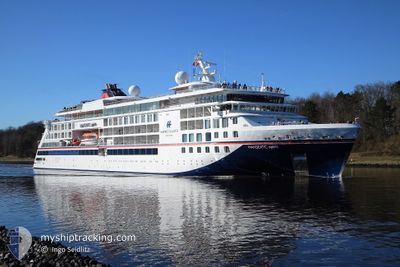
HANSEATIC SPIRIT
Passenger
Current Trip
NENDOE
| Time Travelled | 2 days |
|---|---|
| Remaining Time | --- |
| Distance Travelled | 713.72 nm |
| Remaining Distance | --- |
| AVG Speed | 13.3 Knots |
| MAX Speed | 16 Knots |
| AVG Wind | 10.6 knots |
| MAX Wind | 27.8 knots |
| MIN Temp | 22.3°C / 72.14°F |
| MAX Temp | 29.5°C / 85.1°F |
| Draught | 5.8 m |
| Position Received | 2 d ago |
Current Position
| Longitude | 166.43682° |
|---|---|
| Latitude | -22.27094° |
| Status | Moored |
| Speed | |
| Course | 356° |
| Area | South Pacific Ocean |
| Station | T-AIS |
| Position Received | 2 d ago |
Info
Information
The current position of HANSEATIC SPIRIT is in South Pacific Ocean with coordinates -22.27094° / 166.43682° as reported on 2024-04-21 10:34 by AIS to our vessel tracker app. The vessel's current speed is 0 Knots
The vessel HANSEATIC SPIRIT (IMO: 9857640, MMSI: 215973000) is a Passenger It's sailing under the flag of [MT] Malta.
In this page you can find informations about the vessels current position, last detected port calls, and current voyage information. If the vessels is not in coverage by AIS you will find the latest position.
The current position of HANSEATIC SPIRIT is detected by our AIS receivers and we are not responsible for the reliability of the data. The last position was recorded while the vessel was in Coverage by the Ais receivers of our vessel tracking app.
The current draught of HANSEATIC SPIRIT as reported by AIS is 5.8 meters
Weather
| Temperature | 29.4°C / 84.92°F |
|---|---|
| Wind Speed | 5 knots |
| Direction | 121° ESE |
| Pressure | 1008.6 hPa |
| Humidity | 72.6 % |
| Cloud Coverage | 13 % |
Featured Company
Last Port Calls
| Port | Arrival | Departure | Time In Port |
|---|---|---|---|
| 2024-04-20 16:30 | 2024-04-21 11:34 | 19 h | |
| 2024-03-25 17:50 | 2024-03-26 05:13 | 11 h | |
| 2024-03-18 11:21 | |||
| 2024-03-12 06:29 | 2024-03-13 06:13 | 23 h | |
| 2024-03-10 19:01 | 2024-03-11 07:05 | 12 h | |
| 2024-03-08 17:42 | 2024-03-09 05:15 | 11 h | |
| 2024-03-07 22:39 | 2024-03-08 08:24 | 9 h | |
| 2024-03-01 21:33 | 2024-03-02 06:17 | 8 h | |
| 2024-02-29 16:07 | 2024-03-01 05:43 | 13 h |
Most Visited Ports (Last year)
| Port | Arrivals | |
|---|---|---|
| 4 | ||
| 4 | ||
| 3 | ||
| 3 | ||
| 2 | ||
| 2 |
Last Trips
| Origin | Departure | Destination | Arrival | Distance | |
|---|---|---|---|---|---|
| 2024-03-26 18:13 | 2024-04-21 03:30 | 4433.06 nm | |||
| 2024-03-18 22:21 | 2024-03-26 06:50 | 1530.26 nm | |||
| 2024-03-11 20:05 | 2024-03-12 19:29 | 150.71 nm | |||
| 2024-03-09 18:15 | 2024-03-11 08:01 | 478.18 nm | |||
| 2024-03-08 21:24 | 2024-03-09 06:42 | 65.14 nm | |||
| 2024-03-02 19:17 | 2024-03-08 11:39 | 998.21 nm | |||
| 2024-03-01 18:43 | 2024-03-02 10:33 | 201.70 nm | |||
| 2024-01-28 19:38 | 2024-03-01 05:07 | 6830.87 nm |
Events
| Time | Event | Details | Position / Dest | Info |
|---|---|---|---|---|
| 2024-04-21 11:34 | PORT DEPARTURE |
|
-22.29329 / 166.41539
NENDOE
|
Speed: 9.4 kn Course: 250° |
| 2024-04-21 11:22 | START Moving |
-22.27058 / 166.43463
[NC] NOUMEA
|
Speed: 3.4 kn Course: 278° |
|
| 2024-04-21 10:36 | Status Changed | Default Moored |
-22.27167 / 166.43666
[NC] NOUMEA
|
Speed: Course: 356° |
| 2024-04-21 10:34 | OUT of Coverage |
-22.27094 / 166.43682
South Pacific Ocean
[NC] NOUMEA
|
Speed: Course: 279.7° |
|
| 2024-04-21 10:34 | ETA Changed | 2024/04/23 23:00 2024/04/19 23:00 |
-22.27095 / 166.43682
[NC] NOUMEA
|
Speed: Course: 356° |
| 2024-04-21 10:25 | Status Changed | Moored Default |
-22.27094 / 166.43681
[NC] NOUMEA
|
Speed: Course: -1° |
| 2024-04-21 10:23 | Destination Changed | NENDOE NCNOU |
-22.27167 / 166.43666
[NC] NOUMEA
|
Speed: Course: -1° |
| 2024-04-21 10:23 | ETA Changed | 2024/04/19 23:00 2024/04/20 13:00 |
-22.27167 / 166.43666
[NC] NOUMEA
|
Speed: Course: -1° |
| 2024-04-21 10:18 | IN Coverage |
-22.27094 / 166.43681
South Pacific Ocean
[NC] NOUMEA
|
Speed: Course: 8.4° |
|
| 2024-04-21 01:10 | OUT of Coverage |
-22.27094 / 166.43682
South Pacific Ocean
[NC] NOUMEA
|
Speed: Course: 251° |